
 North is roughly indicated by the looming bulk of a nearby hill called Seefin [Pic].
![[Pic].](Farranamanagh-N.jpg)
South is exactly on Knockaphuca hilltop [Pic].
![[Pic].](Farranamanagh-S.jpg)
To the east of it a lunar sixteenth rises at the head of Dunmanus Bay. To the west the same sixteenth sets into the sea at the northern side of the bay mouth. This would happen at intervals of 7 and then 12 years.
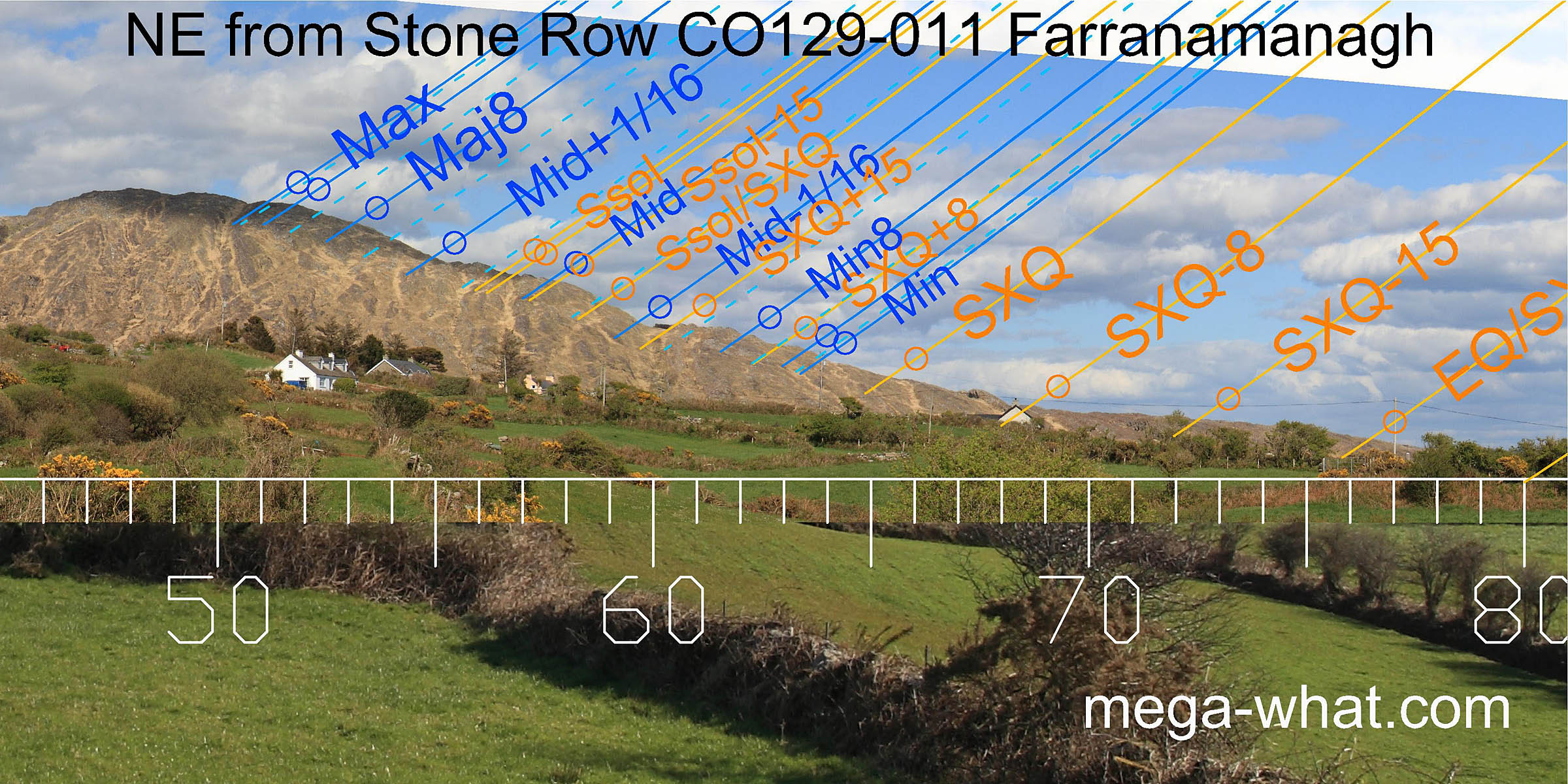 Axially north-eastwards is the rocky south slope of Rosskerrig Mt. where the notch below the summit marks the major lunar limit and a significant step towards the bottom marks the minor one.
The basal step is a quarter-month south of the cross-quarter and Mt. Corrin top is a quarter-month south of the equinox.
Axially north-eastwards is the rocky south slope of Rosskerrig Mt. where the notch below the summit marks the major lunar limit and a significant step towards the bottom marks the minor one.
The basal step is a quarter-month south of the cross-quarter and Mt. Corrin top is a quarter-month south of the equinox.
The remaining upright stone axis indicates summer solstice sunrise [Pic].
![[Pic].](Farranamanagh-NEax.jpg)
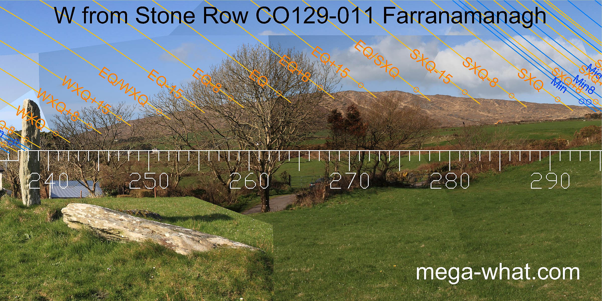
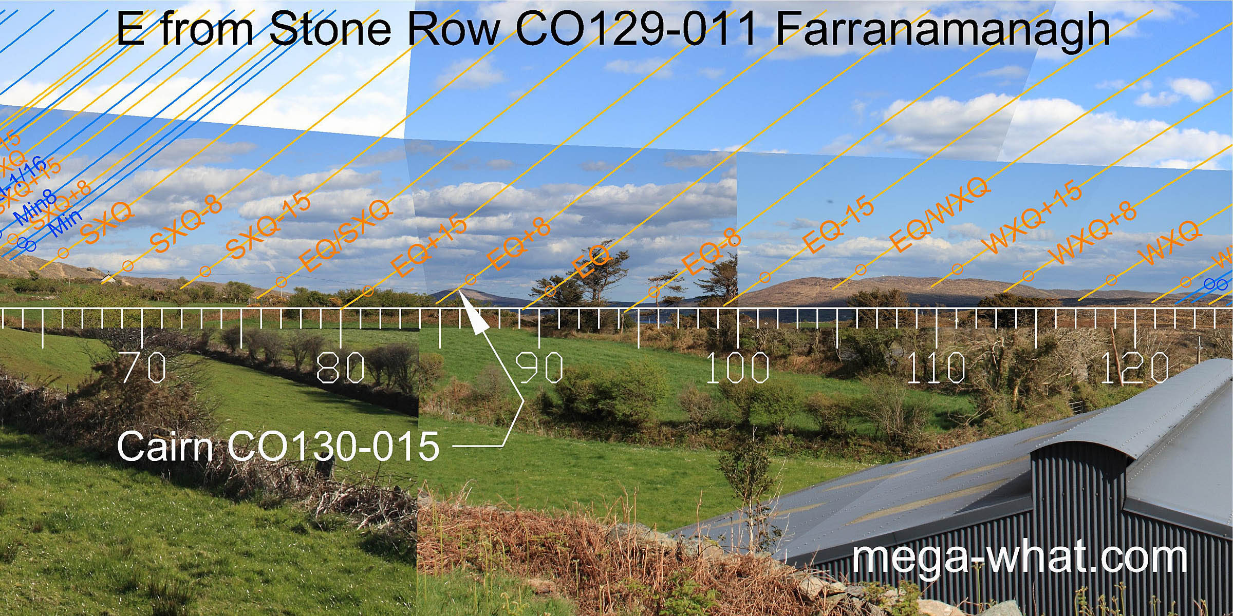 Eastward is a dip. An equinoctial quarter-month bracket is at the bottom of the dip.
The other equinoctial quarter-month bracket is on the summit of Mt Corrin, site of Cairn CO130-015.
The equinox itself is at the hill's south basal break.
Eastward is a dip. An equinoctial quarter-month bracket is at the bottom of the dip.
The other equinoctial quarter-month bracket is on the summit of Mt Corrin, site of Cairn CO130-015.
The equinox itself is at the hill's south basal break.
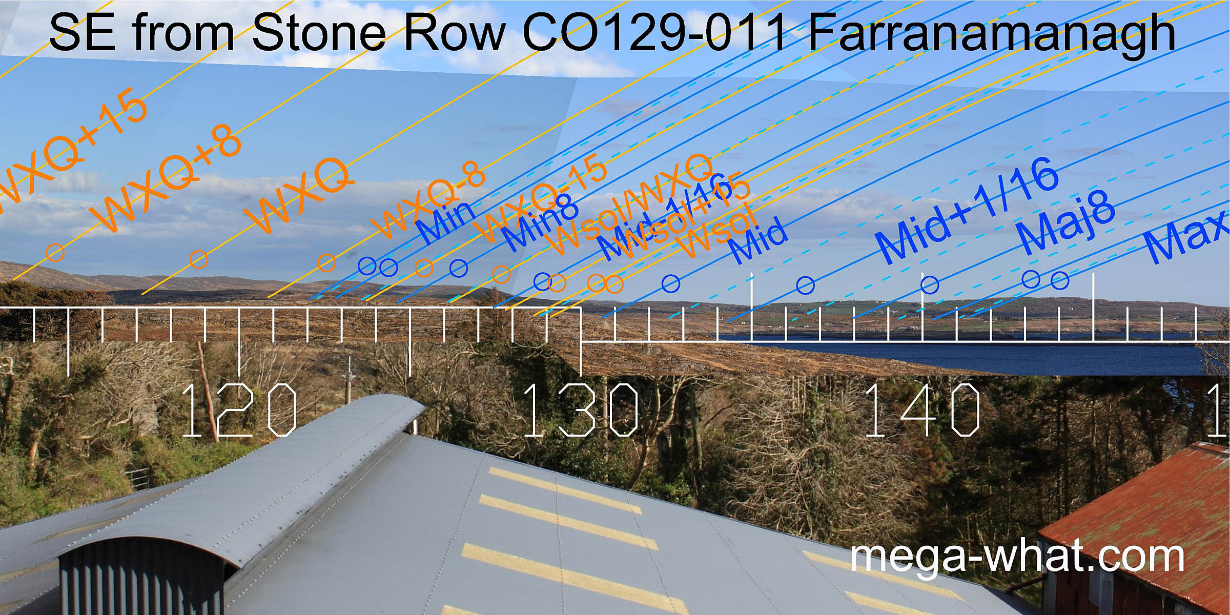 South-east is a descending ridge with useful steps and undulations.
 South-westwards, the row axis is towards the south basal step of Caher Mt and the minor end of the lunisticeLunistices are the most northerly and southerly moons of the month. The lunar equivalent of solstices - more.
range but vegetation prevents accurate survey even in winter
[Pic]. This is also true for the intersect of the peninsula with the sea.
The lunar midpoint seems to be close to the sea/land intersect, perhaps on the land. Winter solstice is certainly on the land.
The most extreme southerly moonset position is across the bay in the prominent dip between Three Castle Head and the Mizen.
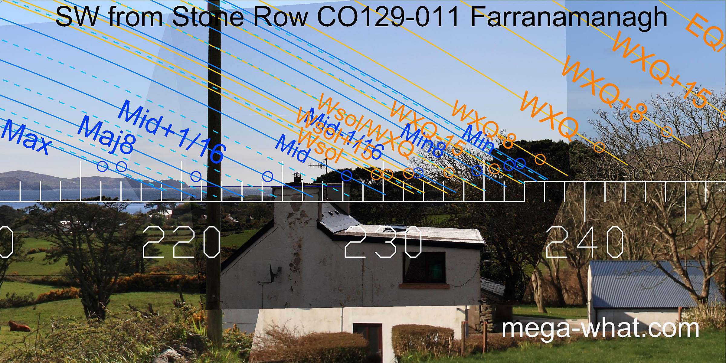
South-westwards, the row axis is towards the south basal step of Caher Mt and the minor end of the lunisticeLunistices are the most northerly and southerly moons of the month. The lunar equivalent of solstices - more.
range but vegetation prevents accurate survey even in winter
[Pic]. This is also true for the intersect of the peninsula with the sea.
The lunar midpoint seems to be close to the sea/land intersect, perhaps on the land. Winter solstice is certainly on the land.
The most extreme southerly moonset position is across the bay in the prominent dip between Three Castle Head and the Mizen.
![[Pic].](Farranamanagh-SWax.jpg)
 North of the axis, above the vegetation, a prominent notch in the ridge of Caher Mt. is the winter cross-quarter/equinox midpoint.
Significant steps either side of the summit mark the equinox and the equinox/summer cross-quarter midpoint.
North of the axis, above the vegetation, a prominent notch in the ridge of Caher Mt. is the winter cross-quarter/equinox midpoint.
Significant steps either side of the summit mark the equinox and the equinox/summer cross-quarter midpoint.
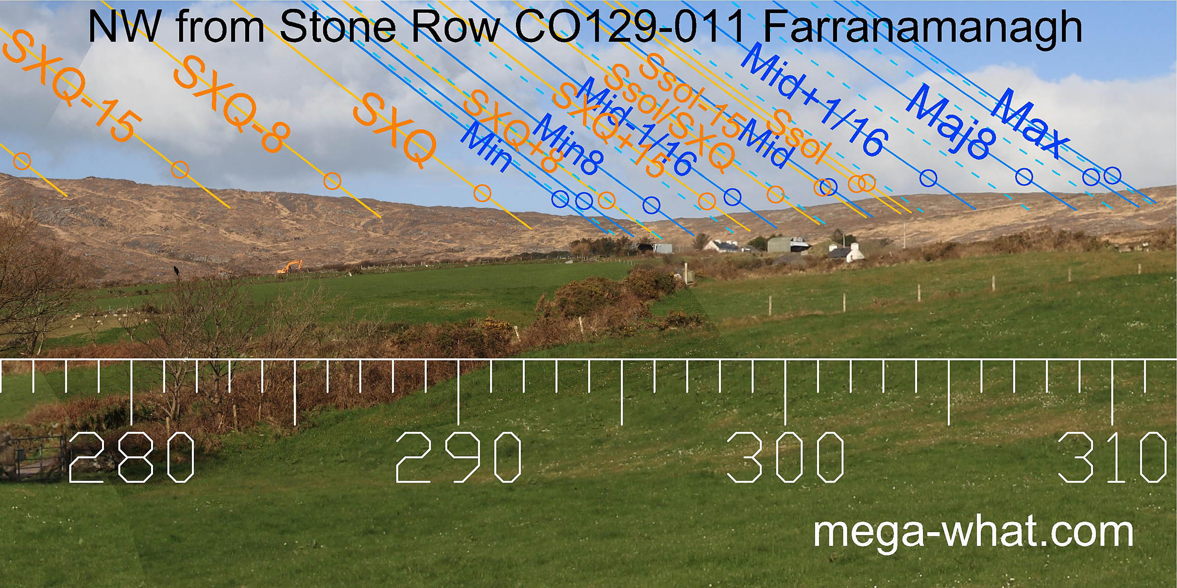 The north basal dip is close to the minor standstillLunistice positions vary cyclically over an 18.6 year period but are fairly static for more than a year at either end of the range,
being a quarter-month north of the cross-quarter. The dip of the next saddle is the major standstillLunistice positions vary cyclically over an 18.6 year period but are fairly static for more than a year at either end of the range.
The north basal dip is close to the minor standstillLunistice positions vary cyclically over an 18.6 year period but are fairly static for more than a year at either end of the range,
being a quarter-month north of the cross-quarter. The dip of the next saddle is the major standstillLunistice positions vary cyclically over an 18.6 year period but are fairly static for more than a year at either end of the range.
- Kilcrohane Standing Stone Pair is 1.2km to the south-south-west.
- Gorteanish Stone Circle is the next monument eastwards.
- Dunmanus East, 6.3km across the bay is the nearest Stone Row and has similarly tall stones.
- Maulinward, built with low stones is the second nearest Stone Row, 17.4km up the valley that runs inland from the head of the bay.
References
- Archaeological Survey of Ireland, record details. www.archaeology.ie/archaeological-survey-ireland
- Ó'NUALLÁIN, SEÁN 1988 Stone Rows in the South of Ireland. Proceedings of the Royal Irish Academy 88c:179-256, p252, no.175.
- POWER, D. et al. 1992 Archaeological Inventory of County Cork, Volume 1: West Cork. Dublin: Stationary Office. p35, no.150.
- RUGGLES, C.L.N. 1999 Astronomy in Prehistoric Britain and Ireland. Newhaven & London: Yale University Press. CKR87.
- RUGGLES, C.L.N. 1996 Stone Rows of Three or More Stones in South-West Ireland. Archaeoastronomy 21 (Journal of the History of Astronomy xxvii) S55-S71.