
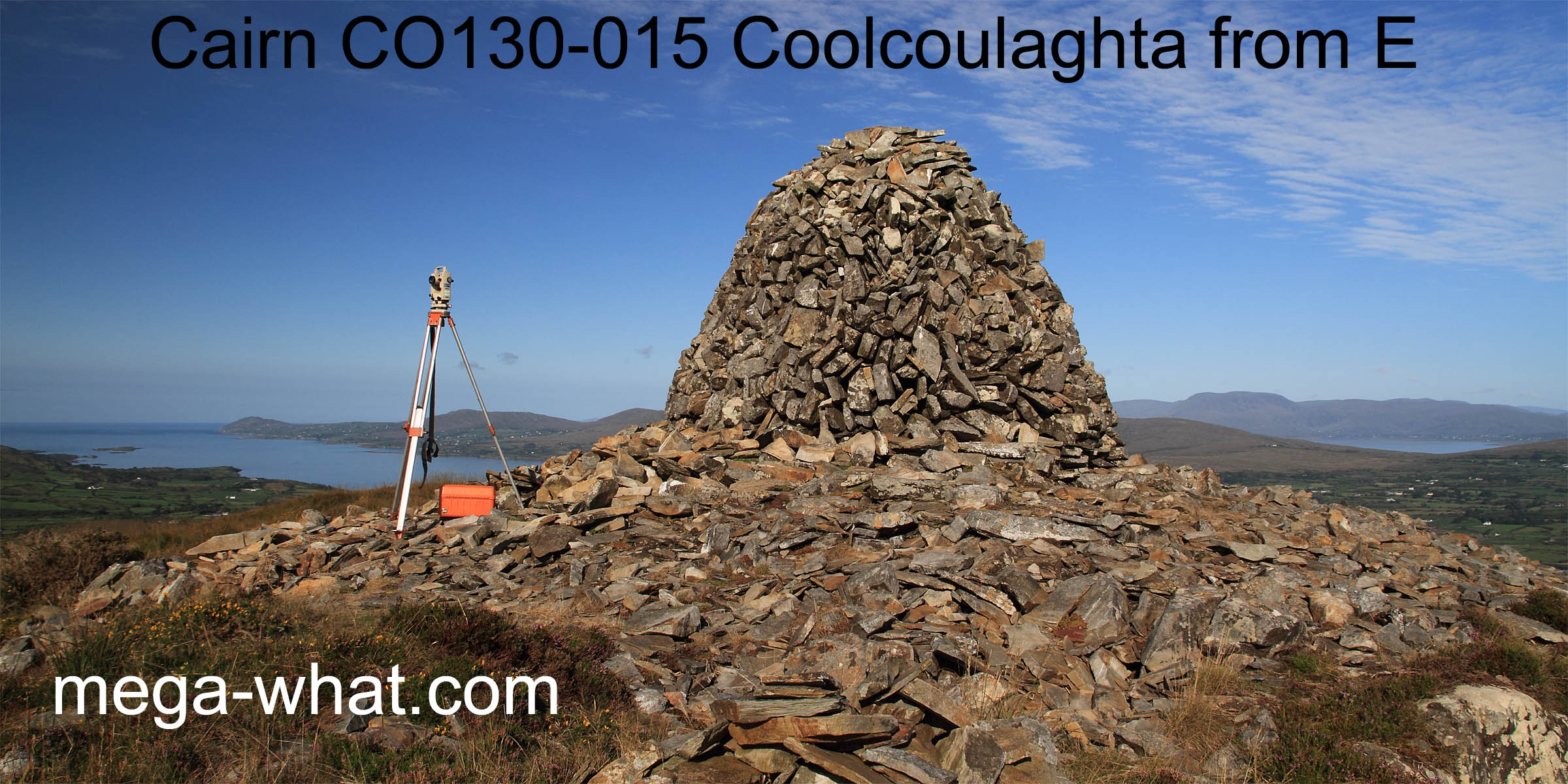
 Coolcoulaghta Cairn is at the western end of the summit ridge of Mt. Corrin. Just over 280m above sea level and about three kilometres south of Durrus.
On a marked footpath it is most accessible from the "Mines" road, between Ballydehob and Durrus and there is some parking.
A steep uphill treck: walking-boots, water, emergency rations and compass recommended but not a bother in good weather.
Coolcoulaghta Cairn is at the western end of the summit ridge of Mt. Corrin. Just over 280m above sea level and about three kilometres south of Durrus.
On a marked footpath it is most accessible from the "Mines" road, between Ballydehob and Durrus and there is some parking.
A steep uphill treck: walking-boots, water, emergency rations and compass recommended but not a bother in good weather.
An upright, modern cairn almost 3m tall and roughly 3.5m in diameter has been built on the ruins of a prehistoric cairn. The latter consists of an approximately circular spread of stones, about 14m across and something less than 1m deep.
 Probably bronze age in date but possibly earlier.
South is indicated by Mt Gabriel, more specifically by its left basal dip and more precisely by the right-hand end of Clear Island [Pic].
![[Pic]](CoolcoulaghtaCairn-S.jpg)
North is at a distant intersect dip over a nearer dip, with the end of the bay and a break in the local ridge as rough guides [Pic].
![[Pic]](CoolcoulaghtaCairn-N.jpg)
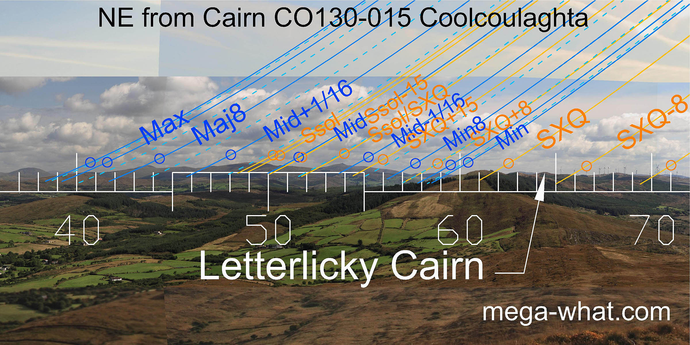 To the north-east, summer cross-quarters are on the end of the local ridge.
The lunisticeLunistices are the most northerly and southerly moons of the month. The lunar equivalent of solstices - more.
range starts at an intersect dip and also ends at one, with summer solstice rising from a hilltop in the middle.
To the north-east, summer cross-quarters are on the end of the local ridge.
The lunisticeLunistices are the most northerly and southerly moons of the month. The lunar equivalent of solstices - more.
range starts at an intersect dip and also ends at one, with summer solstice rising from a hilltop in the middle.
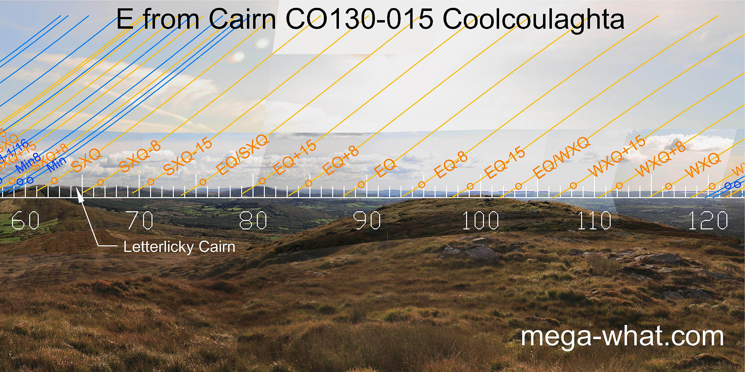 Equinox sunrise is on a distant peak with its half-month brackets on a nearer top and at a sea intersect over the end of this hilltop.
Half-way to the summer cross-quarters is in a dip and half-way to the winter cross-quarters is in a bay of the sea.
Equinox sunrise is on a distant peak with its half-month brackets on a nearer top and at a sea intersect over the end of this hilltop.
Half-way to the summer cross-quarters is in a dip and half-way to the winter cross-quarters is in a bay of the sea.
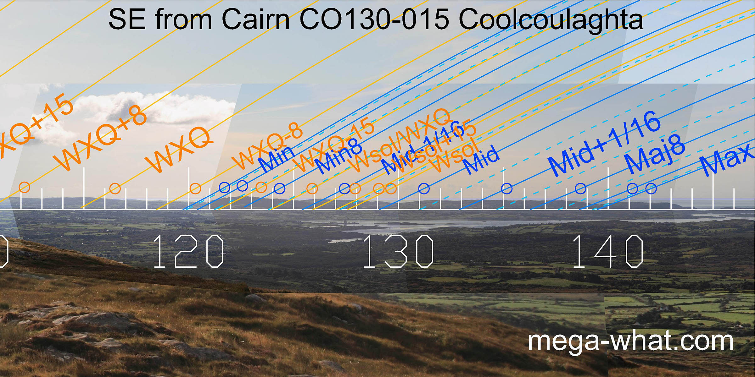 To the south-east, winter cross-quarters are at a land / sea intersect with minor standstillsLunistice positions vary cyclically over an 18.6 year period but are fairly static for more than a year at either end of the range
on the other side of the same bay.
The lunisticeLunistices are the most northerly and southerly moons of the month. The lunar equivalent of solstices - more.
zone then runs along the final peninsula of the mainland.
To the south-east, winter cross-quarters are at a land / sea intersect with minor standstillsLunistice positions vary cyclically over an 18.6 year period but are fairly static for more than a year at either end of the range
on the other side of the same bay.
The lunisticeLunistices are the most northerly and southerly moons of the month. The lunar equivalent of solstices - more.
zone then runs along the final peninsula of the mainland.
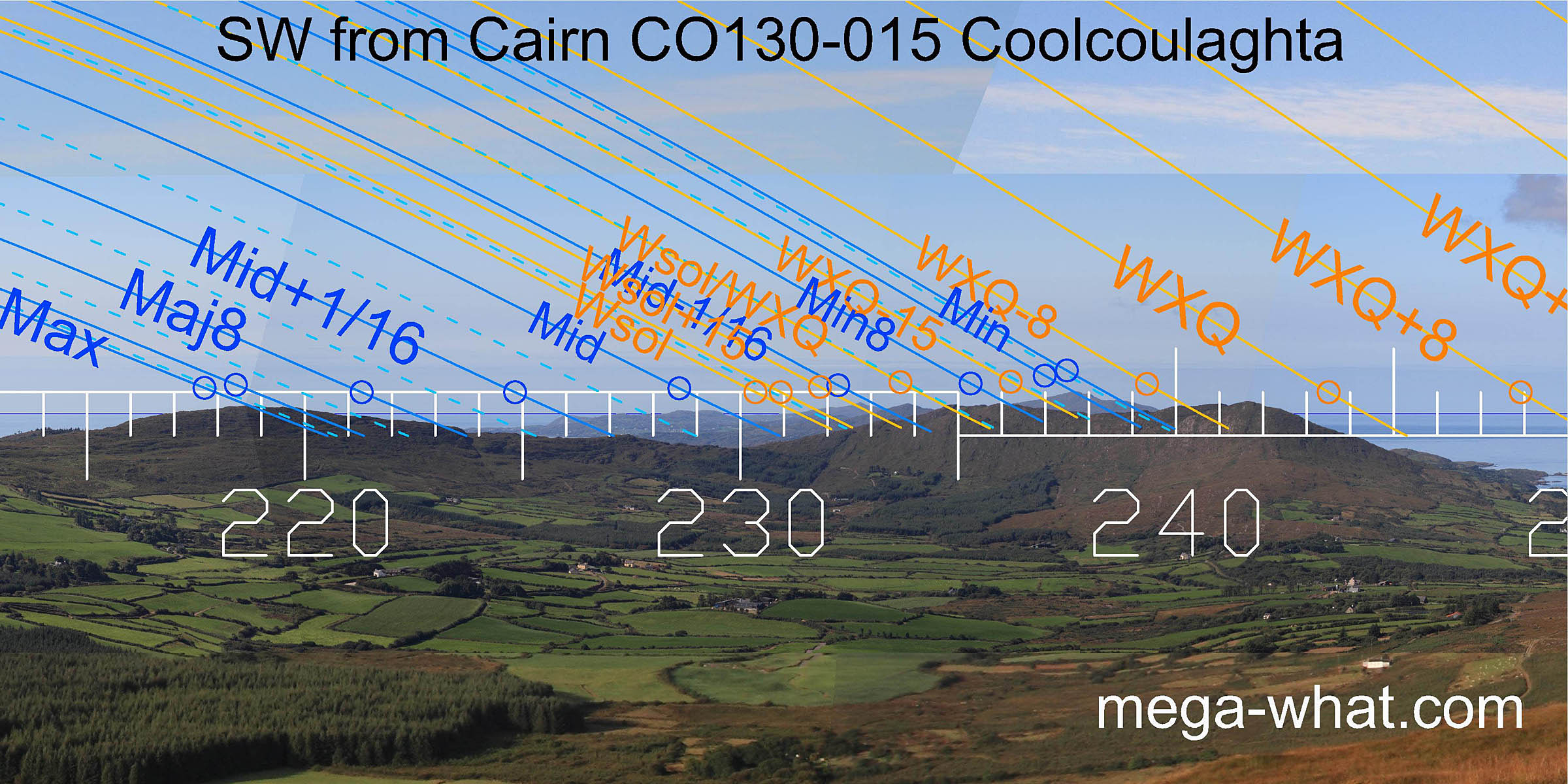 The south-western lunisticeLunistices are the most northerly and southerly moons of the month. The lunar equivalent of solstices - more.
zone spans the dip of the local peninsula end, with both major and minor standstillsLunistice positions vary cyclically over an 18.6 year period but are fairly static for more than a year at either end of the range
on hilltops.
Lunar midpoint is on a low hilltop in the middle with winter solstice at a sea / land intersect.
The south-western lunisticeLunistices are the most northerly and southerly moons of the month. The lunar equivalent of solstices - more.
zone spans the dip of the local peninsula end, with both major and minor standstillsLunistice positions vary cyclically over an 18.6 year period but are fairly static for more than a year at either end of the range
on hilltops.
Lunar midpoint is on a low hilltop in the middle with winter solstice at a sea / land intersect.
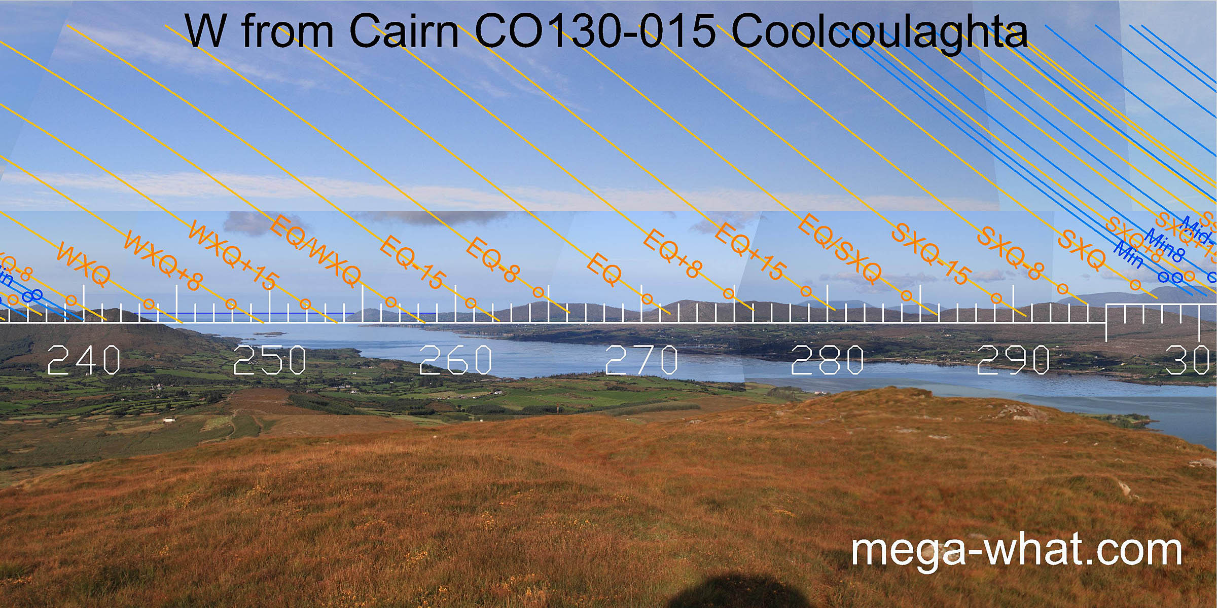 To the west, Dunmanus Bay spans a couple of weeks to the north of the winter cross-quarters then a small bight of sea is half-way to the equinox.
The equinox gets good quarter-month brackets. Further north, the equinox / cross-quarter midpoint is on a distant hilltop over a nearer dip.
To the west, Dunmanus Bay spans a couple of weeks to the north of the winter cross-quarters then a small bight of sea is half-way to the equinox.
The equinox gets good quarter-month brackets. Further north, the equinox / cross-quarter midpoint is on a distant hilltop over a nearer dip.
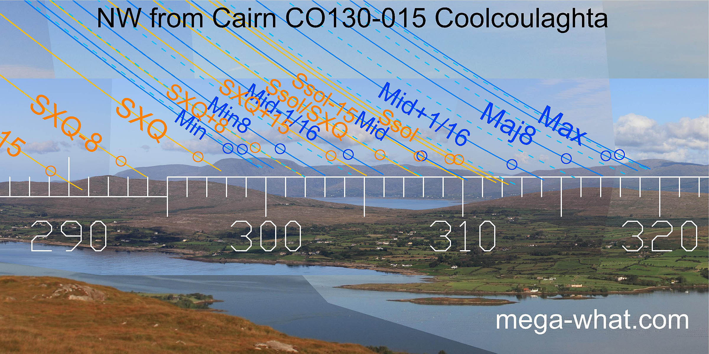 Summer cross-quarters are at the basal step of Hungry Hill which marks the minor end of the lunisticeLunistices are the most northerly and southerly moons of the month. The lunar equivalent of solstices - more.
range.
The major end strains to reach the next major hilltop, just as summer solstice sunsets span the ridge end and strain to reach the central dip.
The lunar midpoint and solstitial half-month bracket get a more precise marker.
Summer cross-quarters are at the basal step of Hungry Hill which marks the minor end of the lunisticeLunistices are the most northerly and southerly moons of the month. The lunar equivalent of solstices - more.
range.
The major end strains to reach the next major hilltop, just as summer solstice sunsets span the ridge end and strain to reach the central dip.
The lunar midpoint and solstitial half-month bracket get a more precise marker.
This cairn is widely visible but there are a limited number of prehistoric sites from which it is on the skyline and even less from which it occupies an astronomically significant position:
- Coolcoulaghta Boulder-Burial is 1.7km away @36°. The nearest site with intervisibility and the cairn marks lunar mid-cycle.
- Gortacloona Standing Stone (fallen) is 7.6km away @35° and the cairn marks most extreme southerly moonset.
- Scartbaun Three Stone Row is 9.15km away @40° and the cairn is not really necessary.
- Rathruane More Boulder-Burial is 3.4km away @137° and the cairn is not significant.
- Bawngare Boulder-Burial is 12.8km away @126° and the cairn is not really significant but this site also has other built targets.
References
- Archaeological Survey of Ireland, record details. www.archaeology.ie/archaeological-survey-ireland
- POWER, D. et al. 1992 Archaeological Inventory of County Cork, Volume 1: West Cork. Dublin: Stationary Office. p101, no.841.