
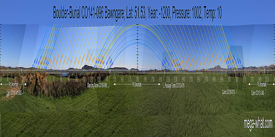
 Bawngare Boulder-Burial is between Ballydehob and Skibbereen, on the peninsula that forms the eastern side of Roaringwater bay.
Only 770m away to the west is Lisheen Boulder-Burial but these two monuments are seemingly not quite intervisible.
Bawngare Boulder-Burial is between Ballydehob and Skibbereen, on the peninsula that forms the eastern side of Roaringwater bay.
Only 770m away to the west is Lisheen Boulder-Burial but these two monuments are seemingly not quite intervisible.
South is on a headland, close to the land/sea intersect [Pic].
![[Pic]](Bawngare-S.jpg)
North is on distant high ground but perhaps not quite on the top [Pic].
![[Pic]](Bawngare-N.jpg)
 South-westwards, the major end of the lunisticeLunistices are the most northerly and southerly moons of the month. The lunar equivalent of solstices - more.
cycle is marked by Clear Island and the minor end by nearby high ground. Between the two is sea horizon but the landscape profile is obscured by hedgerows.
A small island provides a marker for the quarter-month north of the winter cross-quarter but further detail in this area is once again obscured by vegetation.
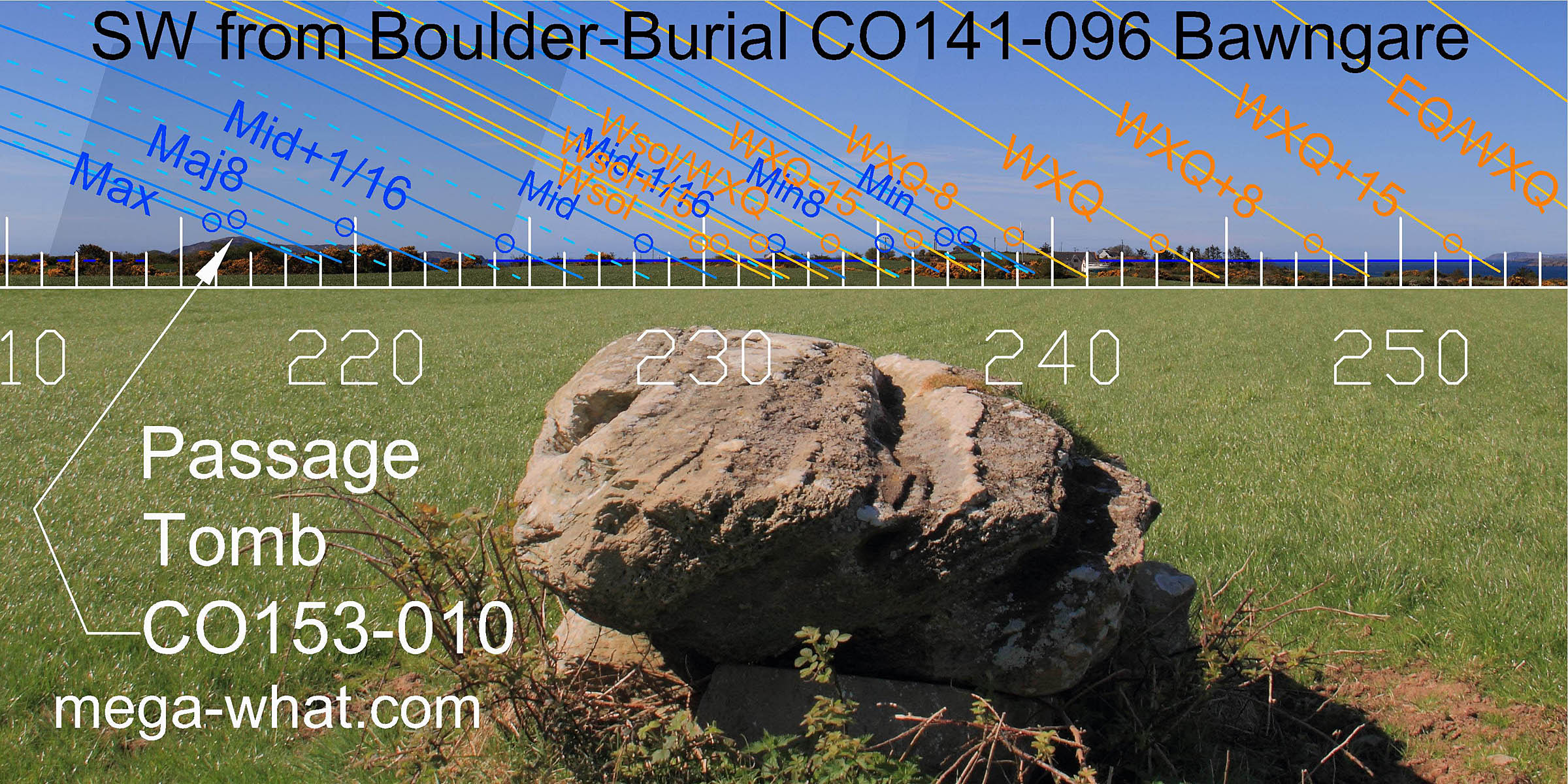
The capstone is long and points to the south-west, the support stones are large and may be used as steps.
This last would appear to be a deliberate design feature as the top of the monument gives a much better south-western view than ground-level.
South-westwards, the major end of the lunisticeLunistices are the most northerly and southerly moons of the month. The lunar equivalent of solstices - more.
cycle is marked by Clear Island and the minor end by nearby high ground. Between the two is sea horizon but the landscape profile is obscured by hedgerows.
A small island provides a marker for the quarter-month north of the winter cross-quarter but further detail in this area is once again obscured by vegetation.
The capstone is long and points to the south-west, the support stones are large and may be used as steps.
This last would appear to be a deliberate design feature as the top of the monument gives a much better south-western view than ground-level.
 Across the bay, the sea/land intersect is a half-month north of the winter cross-quarters.
The half-month south of the summer cross-quarters is on the summit of Mt. Gabriel and equinoctial sunset is in the dip at its southern foot.
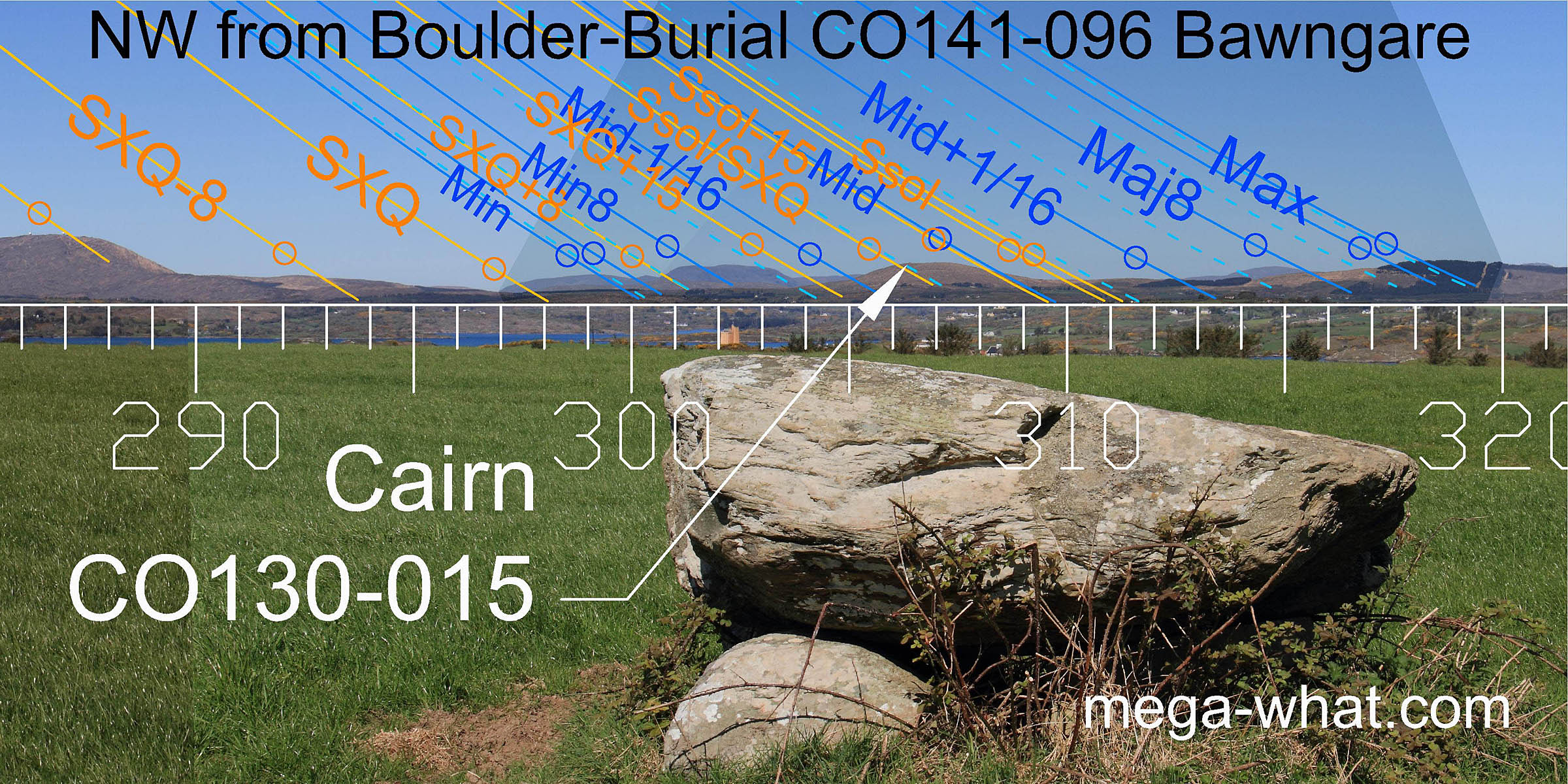 Northwestwards, the lunistice cycle is well marked by a mix of distant and very distant (Beara Peninsula) hills.
Mt. Corrin is prominent, with the lunar midpoint & summer solstice at its northern foot and its western summit marking the halfway point between solstice and cross-quarters. This hilltop is crowned by Cairn CO130-015.
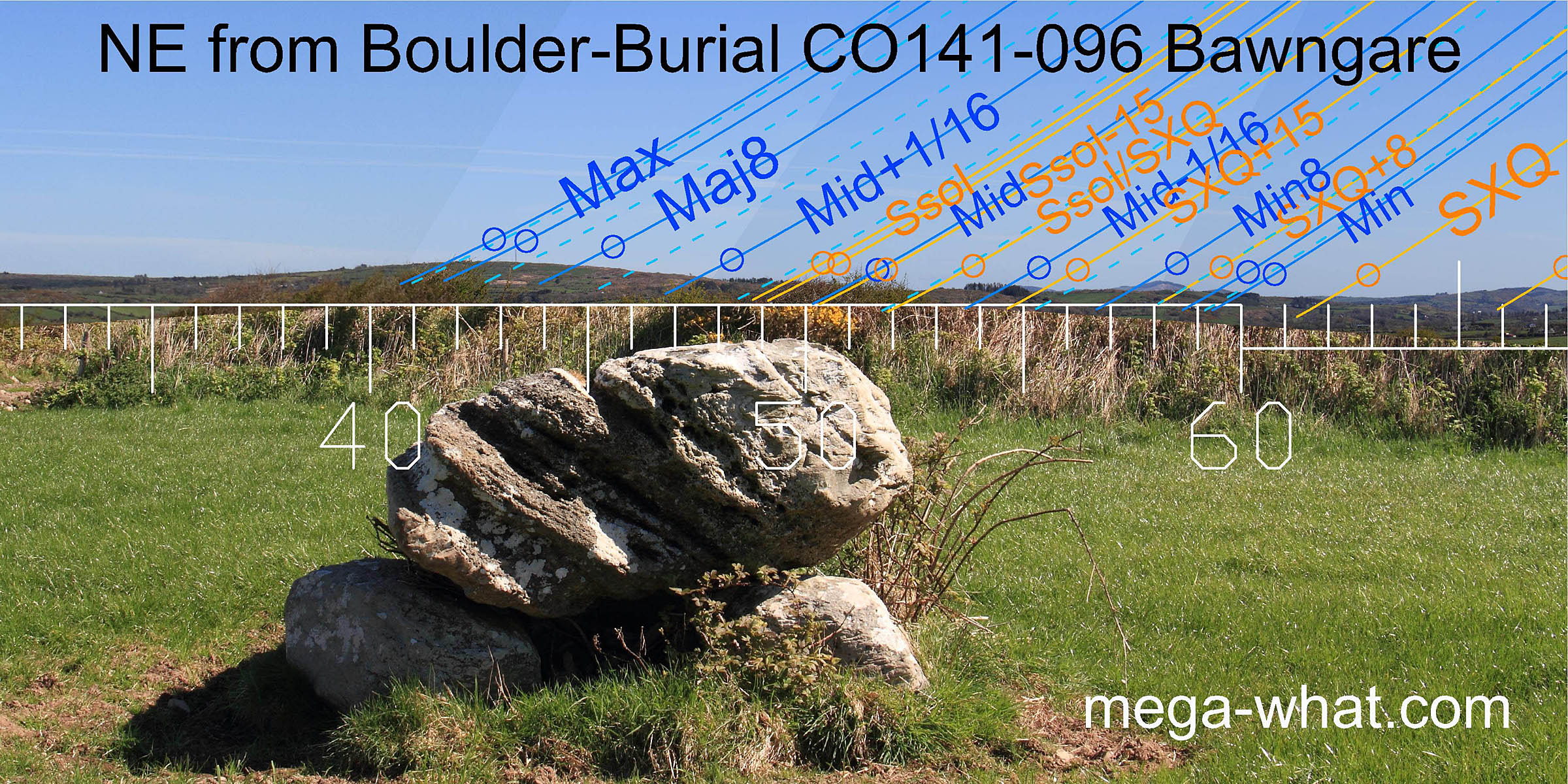 To the north-east, the top of Knockonna marks the lunar extreme northerly rising position and the midpoint of the cycle falls at the hill's south base.
The minor end of the cycle is marked by distant hills then the next two hilltops mark the summer cross-quarters and a quarter-month to their south.
To the north-east, the top of Knockonna marks the lunar extreme northerly rising position and the midpoint of the cycle falls at the hill's south base.
The minor end of the cycle is marked by distant hills then the next two hilltops mark the summer cross-quarters and a quarter-month to their south.
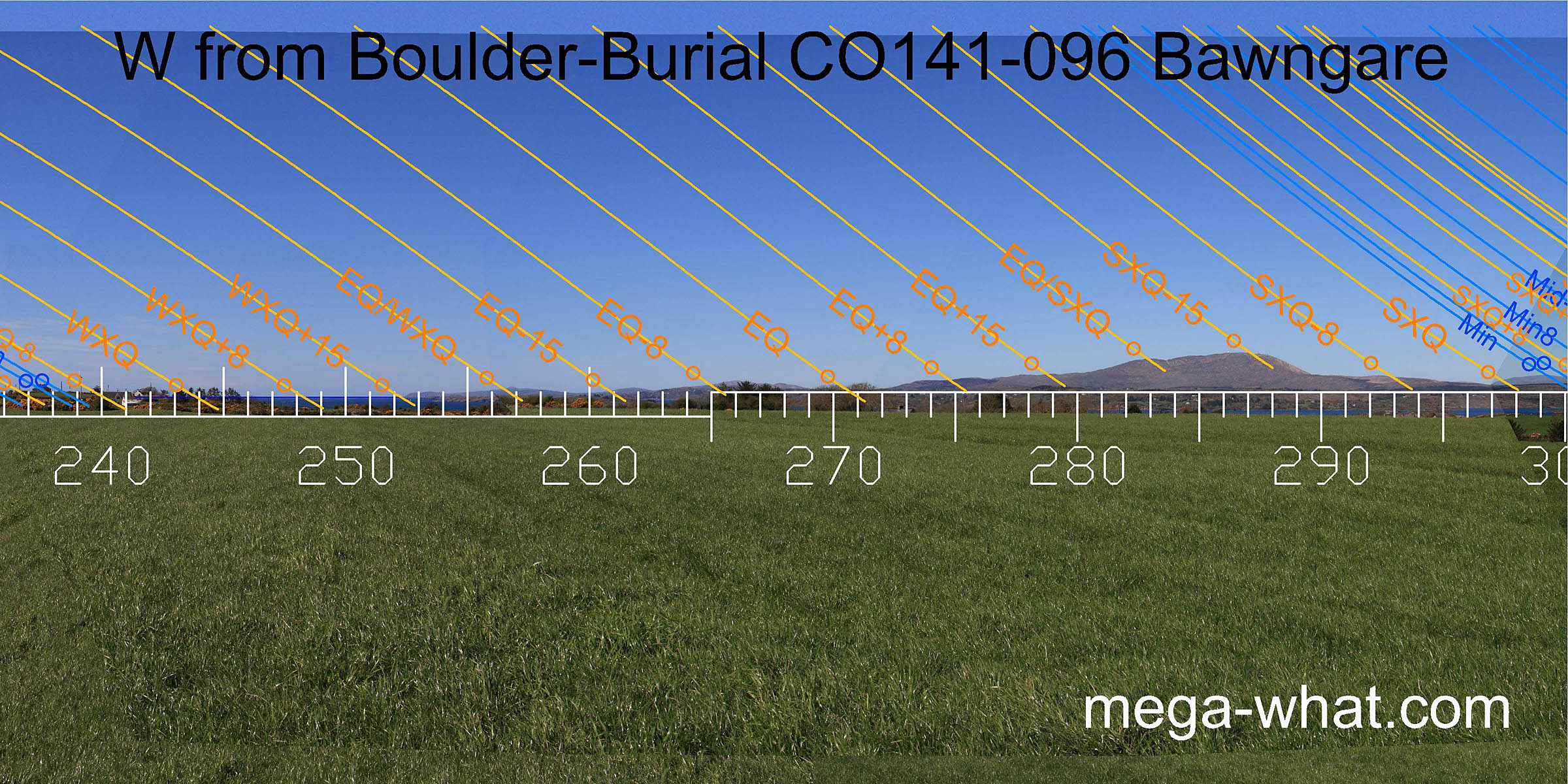
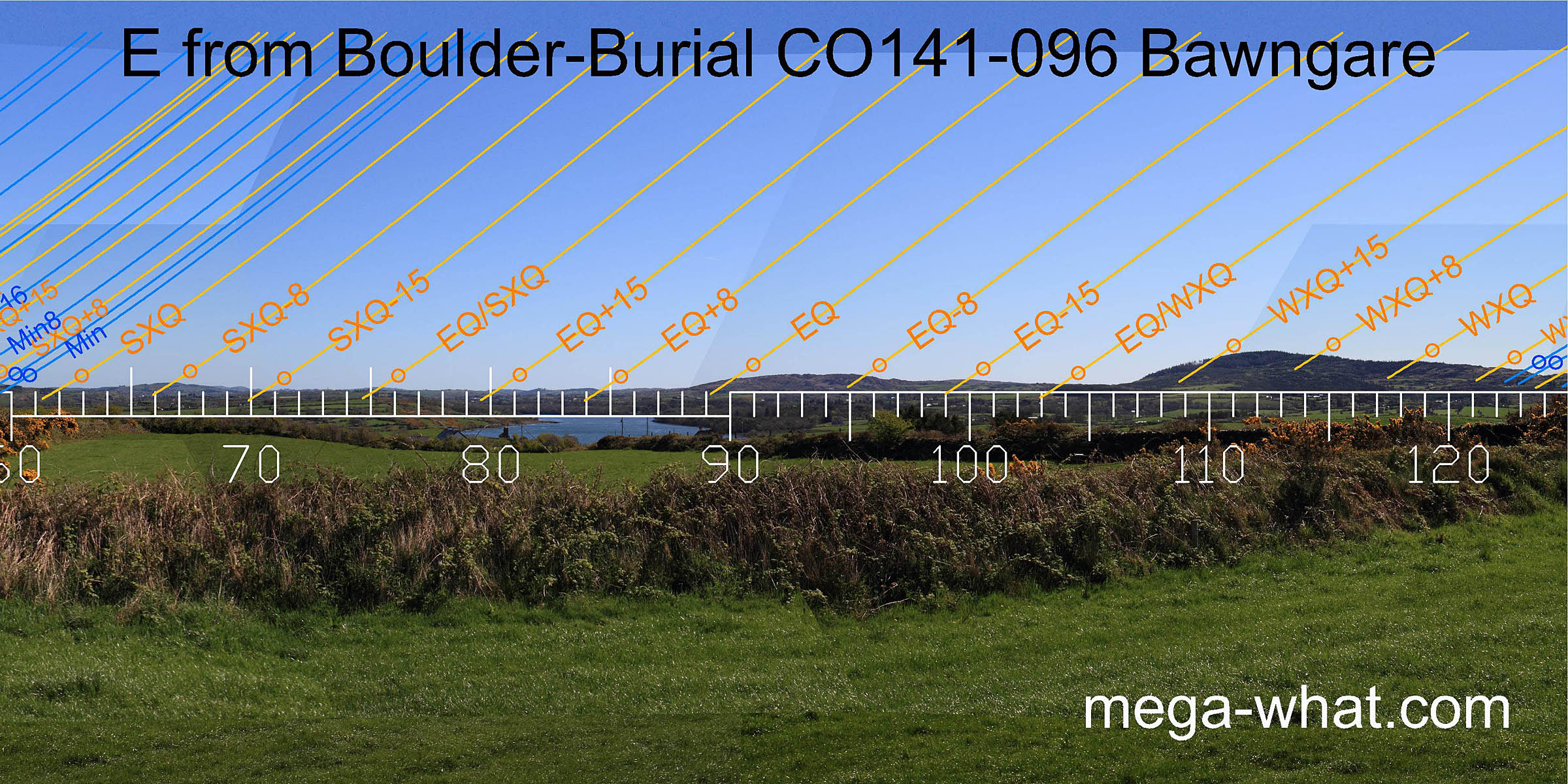 The eastern horizon is undramatic but remarkably useful. At the southern end, the prominent hill of Knockomagh begins a good sequence.
The winter cross-quarters are at a break on its ridge with quarter-month brackets either side, on the hilltop and at a notch towards the ridge end.
The eastern horizon is undramatic but remarkably useful. At the southern end, the prominent hill of Knockomagh begins a good sequence.
The winter cross-quarters are at a break on its ridge with quarter-month brackets either side, on the hilltop and at a notch towards the ridge end.
 The very end of Knockomagh ridge marks the minor end of the lunistice range.
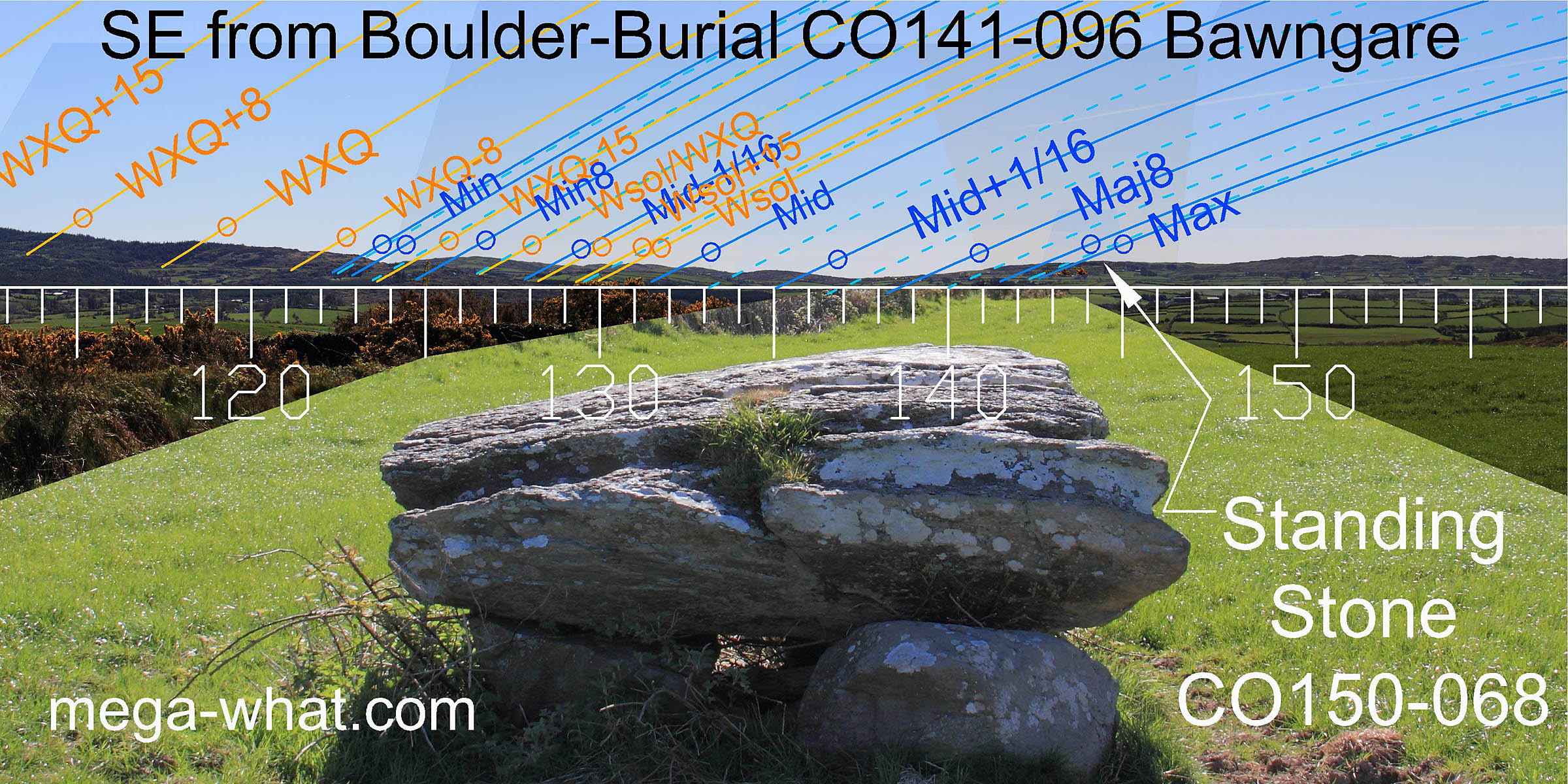
Further south-eastwards a nice run of hills continues the sequence from the lunar sixteenth at the foot of Knockomagh to the lunar midpoint.
the lunar minor eighth is marked by a hilltop, or more accurately, by a level area just east of the top.
The major end of the lunistice range is marked by Ballymacrown Standing Stone,
which is a wide slab set so that its profile is maximised when viewed from this direction.
The eighth and sixteenth in the wide dip east of this stone do not have good natural markers and perhaps they once had built ones too.
The very end of Knockomagh ridge marks the minor end of the lunistice range.
Further south-eastwards a nice run of hills continues the sequence from the lunar sixteenth at the foot of Knockomagh to the lunar midpoint.
the lunar minor eighth is marked by a hilltop, or more accurately, by a level area just east of the top.
The major end of the lunistice range is marked by Ballymacrown Standing Stone,
which is a wide slab set so that its profile is maximised when viewed from this direction.
The eighth and sixteenth in the wide dip east of this stone do not have good natural markers and perhaps they once had built ones too.
- Lisheen Boulder-Burial is 770m to the west (288°)
- Oldcourt Boulder-Burial is 4.5km to the east (88°)
References
- Archaeological Survey of Ireland, record details. www.archaeology.ie/archaeological-survey-ireland
- Ó'NUALLÁIN, SEÁN 1978 Boulder-Burials. Proceedings of the Royal Irish Academy 78c:75-114, p94, no.30.
- POWER, D. et al. 1992 Archaeological Inventory of County Cork, Volume 1: West Cork. Dublin: Stationary Office. p29, no.101.