
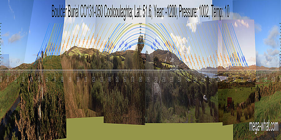
 Coolcoulaghta Boulder-Burial is a couple of kilometres south of Durrus and fairly close to the road. It is the closest one to the head of Dunmanus Bay.
South is on the left hand side of a dip [Pic].
![[Pic].](CoolcoulaghtaBB-S.jpg)
North is also in a dip but on the left hand side of a hilltop [Pic].
![[Pic].](CoolcoulaghtaBB-N.jpg)
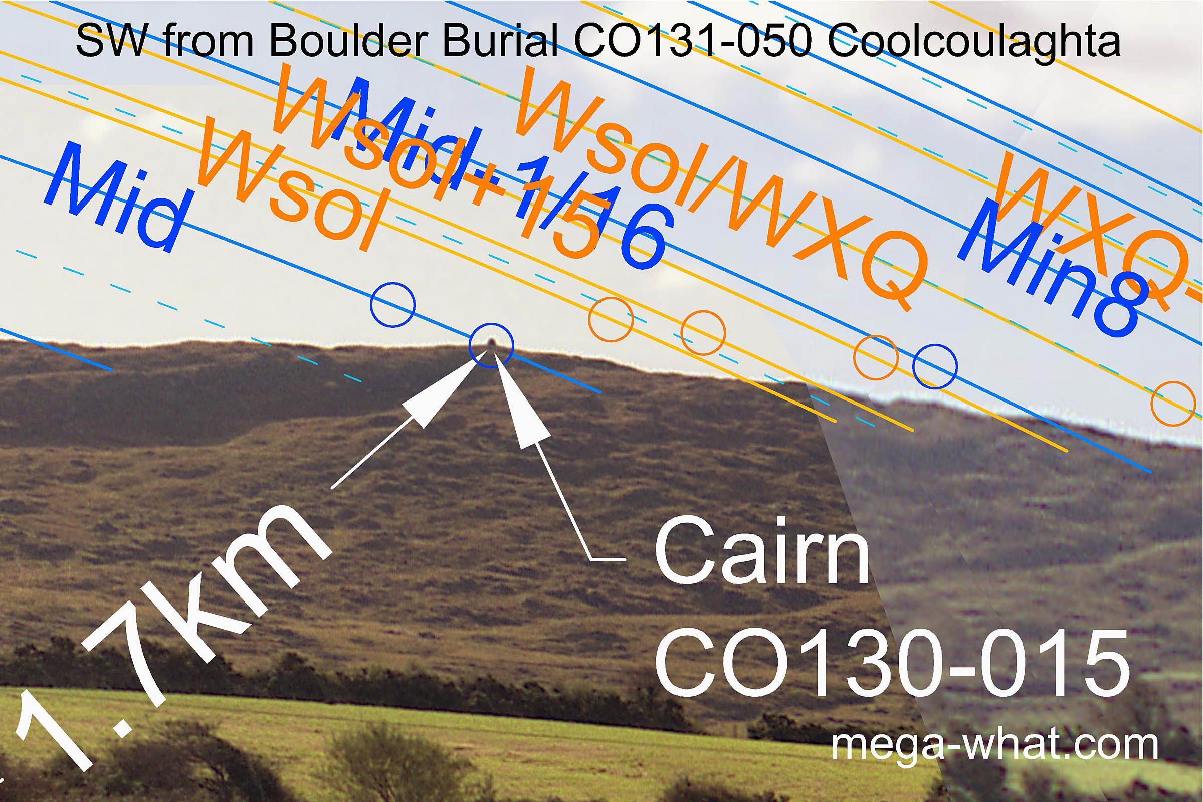 Cairn CO130-015 on nearby Mt. Corrin is very prominent on the skyline from this Boulder-Burial and
accurately marks the midpoint of the lunisticeLunistices are the most northerly and southerly moons of the month. The lunar equivalent of solstices - more.
cycle.
An upright, modern cairn has been built on top of a c.14m diameter spread of stone but probably only goes part way to restoring the visibility of the original.
Cairn CO130-015 on nearby Mt. Corrin is very prominent on the skyline from this Boulder-Burial and
accurately marks the midpoint of the lunisticeLunistices are the most northerly and southerly moons of the month. The lunar equivalent of solstices - more.
cycle.
An upright, modern cairn has been built on top of a c.14m diameter spread of stone but probably only goes part way to restoring the visibility of the original.
 The boulder is not pointed towards the cairn but at the eastern hillslope where a slight but nonetheless noticeable
(once one's attention has been drawn to it) rocky hump marks the major standstillLunistice positions vary cyclically over an 18.6 year period but are fairly static for more than a year at either end of the range.
The hill's eastern top is accurate for the major eighth but markers at the western end are less dramatic.
Winter solstice and the minor half of the lunisticeLunistices are the most northerly and southerly moons of the month. The lunar equivalent of solstices - more.
range fall on a rocky ridge which, being north facing, stretches things out to give improved accuracy.
The boulder is not pointed towards the cairn but at the eastern hillslope where a slight but nonetheless noticeable
(once one's attention has been drawn to it) rocky hump marks the major standstillLunistice positions vary cyclically over an 18.6 year period but are fairly static for more than a year at either end of the range.
The hill's eastern top is accurate for the major eighth but markers at the western end are less dramatic.
Winter solstice and the minor half of the lunisticeLunistices are the most northerly and southerly moons of the month. The lunar equivalent of solstices - more.
range fall on a rocky ridge which, being north facing, stretches things out to give improved accuracy.
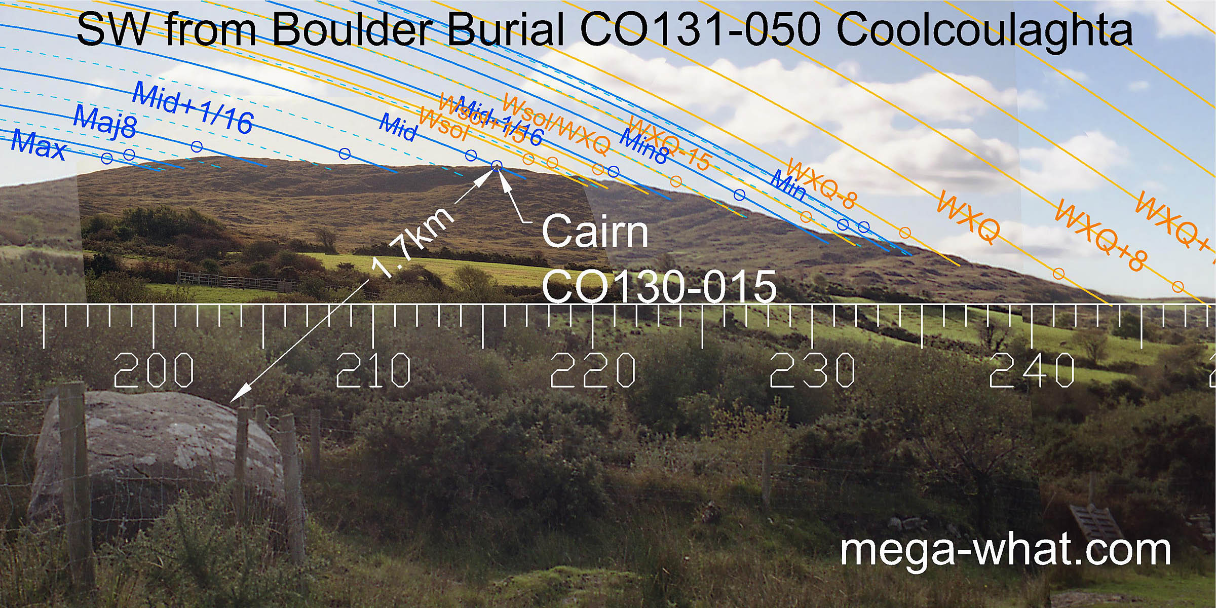
The next really obvious markers are the steps at the base of the slope, marking the winter cross-quarter and the half-month bracket to its south.
 The notch formed by the intersection of near and more distant horizons marks the cross-quarter's other bracket, a half-month to the north.
Then the hills of the Muintirvara Peninsula usefully cover the equinoctial zone.
Hungry Hill on the Beara Peninsula, visible through a saddle, marks the summer cross-quarter together with the quarter and half-month brackets to its south.
The notch formed by the intersection of near and more distant horizons marks the cross-quarter's other bracket, a half-month to the north.
Then the hills of the Muintirvara Peninsula usefully cover the equinoctial zone.
Hungry Hill on the Beara Peninsula, visible through a saddle, marks the summer cross-quarter together with the quarter and half-month brackets to its south.
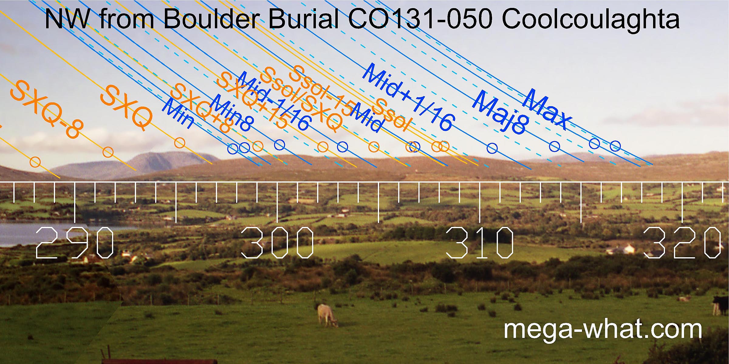 A run of nearer hills spans the first part of the lunisticeLunistices are the most northerly and southerly moons of the month. The lunar equivalent of solstices - more.
range and the remainder of the solar year.
Summer solstice sunset falls on the last top before distant hills again mark out the major end of the lunisticeLunistices are the most northerly and southerly moons of the month. The lunar equivalent of solstices - more.
range.
A run of nearer hills spans the first part of the lunisticeLunistices are the most northerly and southerly moons of the month. The lunar equivalent of solstices - more.
range and the remainder of the solar year.
Summer solstice sunset falls on the last top before distant hills again mark out the major end of the lunisticeLunistices are the most northerly and southerly moons of the month. The lunar equivalent of solstices - more.
range.
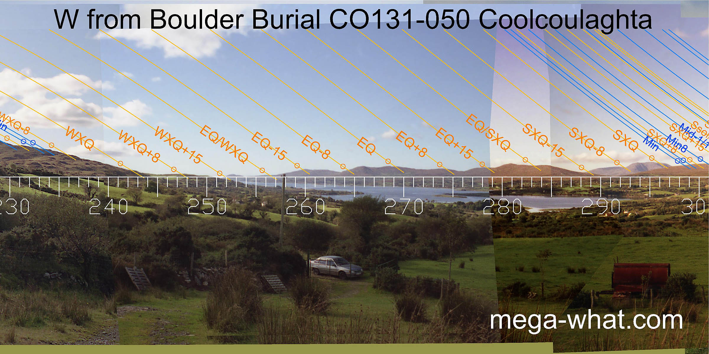
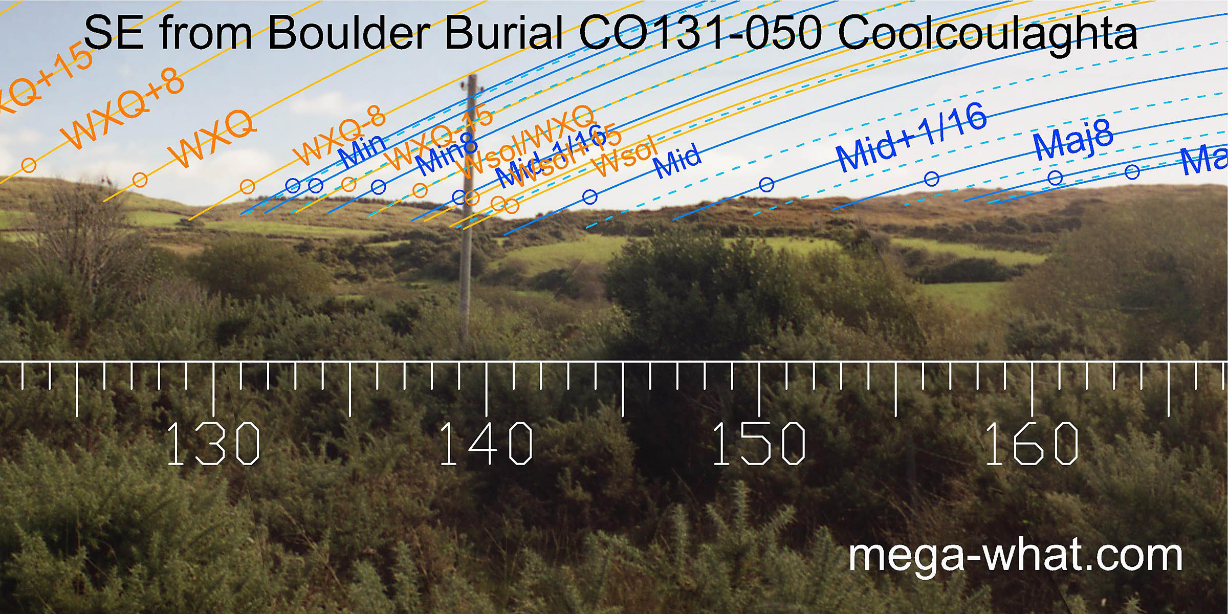 To the south-east, a low hill has the winter cross-quarter's quarter month bracket at its north base and the winter solstice at its south base.
The lunisticeLunistices are the most northerly and southerly moons of the month. The lunar equivalent of solstices - more.
range runs from the east top of the hill down to the solstitial dip and up the slope to the other side.
To the south-east, a low hill has the winter cross-quarter's quarter month bracket at its north base and the winter solstice at its south base.
The lunisticeLunistices are the most northerly and southerly moons of the month. The lunar equivalent of solstices - more.
range runs from the east top of the hill down to the solstitial dip and up the slope to the other side.
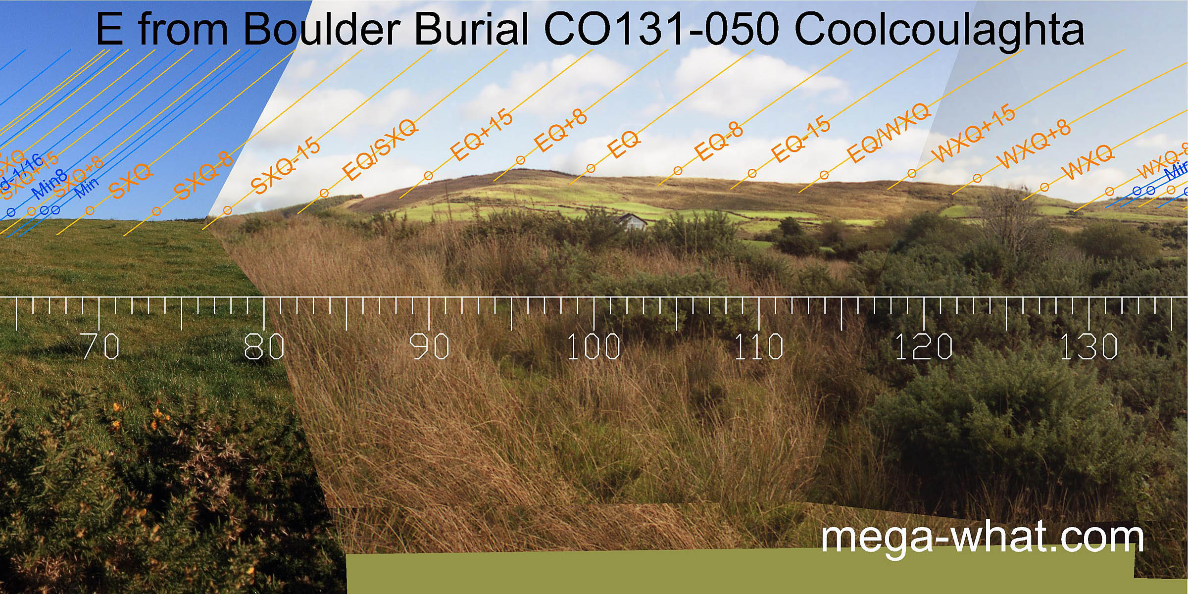 To the east, the fit is not so obvious though there are some usable markers. Notably the equinox at the south base of a hill and the quarter-month north of it on the hilltop.
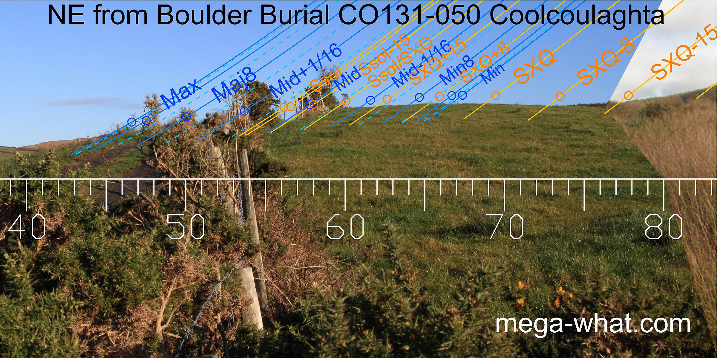 Views to the north-east are almost entirely local with the lunisticeLunistices are the most northerly and southerly moons of the month. The lunar equivalent of solstices - more.
range falling over the top of the rise while the major standstillLunistice positions vary cyclically over an 18.6 year period but are fairly static for more than a year at either end of the range
is at the intersect with further horizons.
A short walk in that direction yields more of the distant view but its astronomical utility has not been checked as there is no obvious viewpoint.
Views to the north-east are almost entirely local with the lunisticeLunistices are the most northerly and southerly moons of the month. The lunar equivalent of solstices - more.
range falling over the top of the rise while the major standstillLunistice positions vary cyclically over an 18.6 year period but are fairly static for more than a year at either end of the range
is at the intersect with further horizons.
A short walk in that direction yields more of the distant view but its astronomical utility has not been checked as there is no obvious viewpoint.
This site may be viewed as the first step in a penetration inland from Dunmanus Bay by the Boulder-Burial culture: Four kilometres further along the valley to the north-east is
- Ballycommane and then after a further six kilometres comes
- Cullomane East the best of the three.
References
- Archaeological Survey of Ireland, record details. www.archaeology.ie/archaeological-survey-ireland
- POWER, D. et al. 1992 Archaeological Inventory of County Cork, Volume 1: West Cork. Dublin: Stationary Office. p31, no.112.