
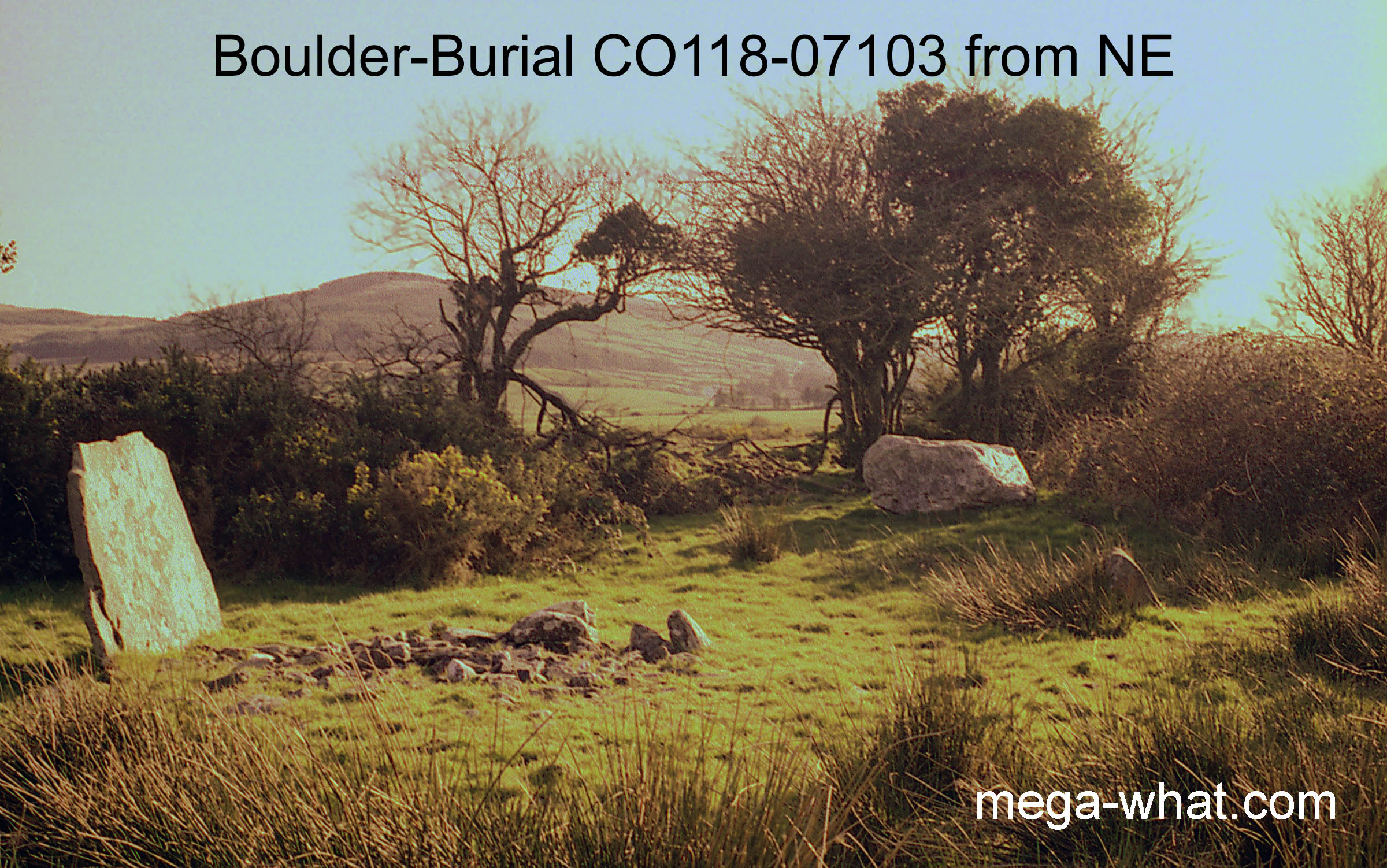
 The stones in the foreground are a penitential cairn with more in the next field.
Saint Colman supposedly lived here for a time and the drying up of a holy well named for him has caused the abandonment of the site for religious purposes.
The inventory descriptions of this site are, at time of writing, incorrect. The boulder (1.32m x 1.22 x 0.76 thick) indicates the south-east.
There is a small outlying Standing Stone (0.61m x 0.51 x 0.25, axis 83°) a little to its north, a thin slab (1.22m x 1.52 x 0.15, axis 214°) just to its east
and another low Standing Stone (0.86m x 0.81 x 0.30, axis 156°) a further 23.5m east again.
These stones may represent variant observing positions for particular events. Views from the site are much constrained by vegetation.
The stones in the foreground are a penitential cairn with more in the next field.
Saint Colman supposedly lived here for a time and the drying up of a holy well named for him has caused the abandonment of the site for religious purposes.
The inventory descriptions of this site are, at time of writing, incorrect. The boulder (1.32m x 1.22 x 0.76 thick) indicates the south-east.
There is a small outlying Standing Stone (0.61m x 0.51 x 0.25, axis 83°) a little to its north, a thin slab (1.22m x 1.52 x 0.15, axis 214°) just to its east
and another low Standing Stone (0.86m x 0.81 x 0.30, axis 156°) a further 23.5m east again.
These stones may represent variant observing positions for particular events. Views from the site are much constrained by vegetation.
South is on the eastern slope of a dip [Pic]. To both sides the luni-solar sequence runs down through a dip and up again, terminating just beyond the high point.
![[Pic].](ColomaneBB-S.jpg)
North is obscured but on the western slope of a dip [Pic].
![[Pic].](ColomaneBB-N.jpg)
Green lines approximate hidden horizon segments.
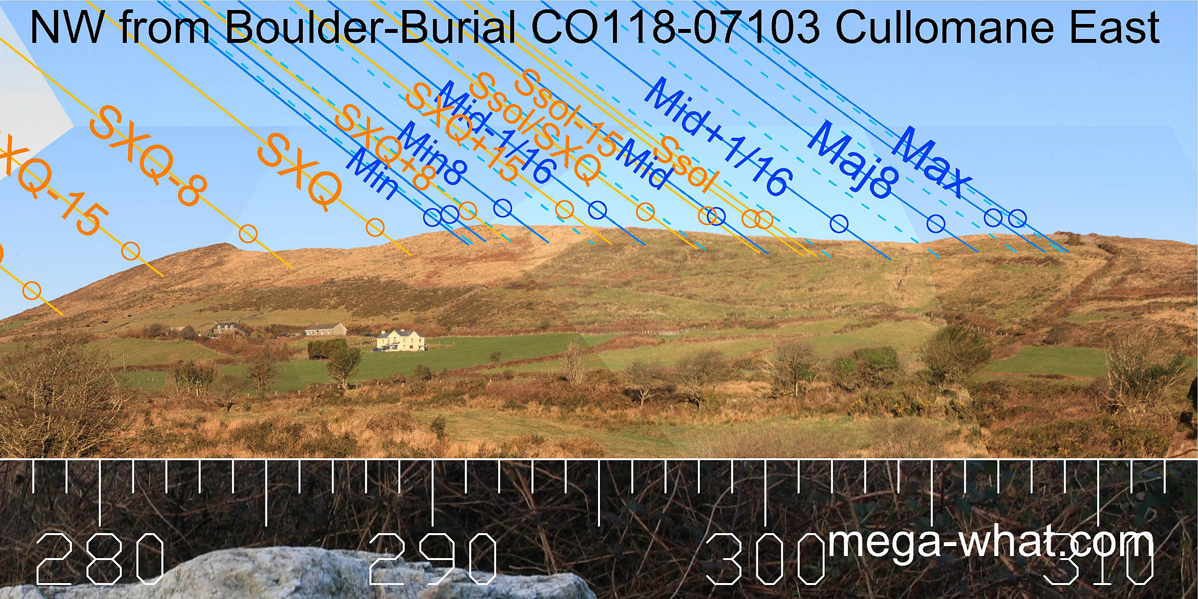
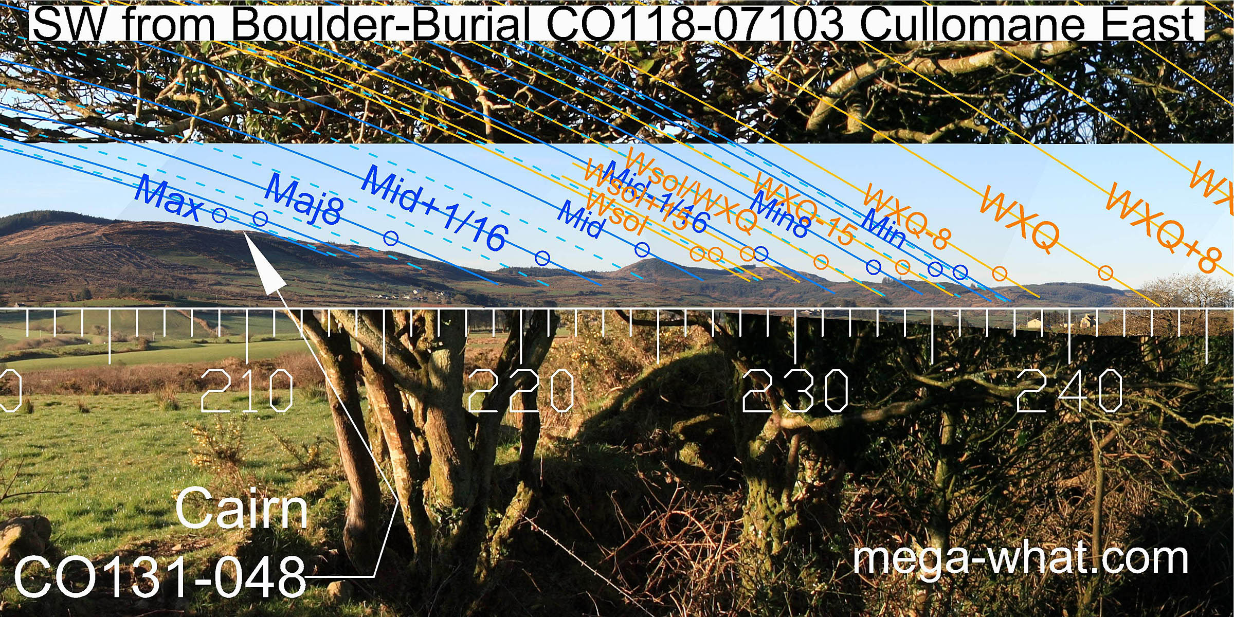 South-westwards, the very end of the ridge and its intersect with nearer ground is concealed by trees. Winter cross-quarters are marked by the notch between the ridge and its terminal hilltop.
The next nearer notch marks the minor end of the lunisticeLunistices are the most northerly and southerly moons of the month. The lunar equivalent of solstices - more.
range.
A prominent pair of hills are used for the lunar midpoint, the winter solstice and its half-month bracket.
East of the hills is a saddle which marks the major eighth, then Cairn CO131-048
marks the major end of the lunisticeLunistices are the most northerly and southerly moons of the month. The lunar equivalent of solstices - more.
range and was possibly built for this purpose.
A line from the very small Standing Stone, through the boulder-burial indicates this cairn [Pic].
South-westwards, the very end of the ridge and its intersect with nearer ground is concealed by trees. Winter cross-quarters are marked by the notch between the ridge and its terminal hilltop.
The next nearer notch marks the minor end of the lunisticeLunistices are the most northerly and southerly moons of the month. The lunar equivalent of solstices - more.
range.
A prominent pair of hills are used for the lunar midpoint, the winter solstice and its half-month bracket.
East of the hills is a saddle which marks the major eighth, then Cairn CO131-048
marks the major end of the lunisticeLunistices are the most northerly and southerly moons of the month. The lunar equivalent of solstices - more.
range and was possibly built for this purpose.
A line from the very small Standing Stone, through the boulder-burial indicates this cairn [Pic].
![[Pic].](ColomaneBB-SWax.jpg)
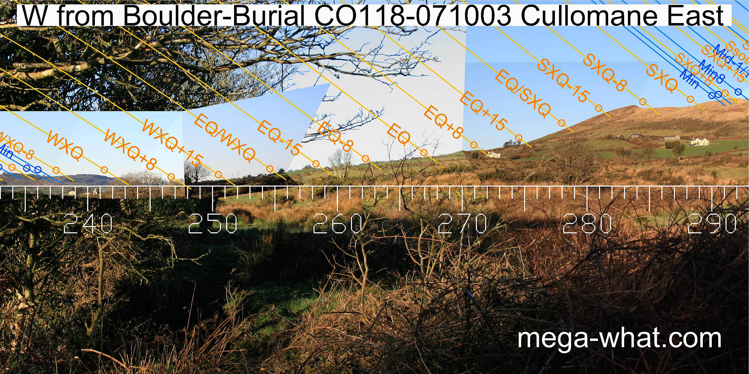 Westwards, the view down the valley is obscured and the northern upslope is relatively featureless though there are some slight bumps and dips usefully situated in the zone around the equinox.
The south foot of Spratt Hill is more or less a half-month north of the equinox while the dip after its summit is a quarter-month south of the cross-quarter.
Westwards, the view down the valley is obscured and the northern upslope is relatively featureless though there are some slight bumps and dips usefully situated in the zone around the equinox.
The south foot of Spratt Hill is more or less a half-month north of the equinox while the dip after its summit is a quarter-month south of the cross-quarter.
 To the north-west, Spratt Hill begins an undulating ridge. Quarter-month brackets for the summer cross-quarter occur at the first dip and first high point,
with the minor end of the lunisticeLunistices are the most northerly and southerly moons of the month. The lunar equivalent of solstices - more.
range just before the latter. The major standstillLunistice positions vary cyclically over an 18.6 year period but are fairly static for more than a year at either end of the range
is marked by the second hilltop on the ridge.
It has a central dip which is accurate for the sixteenth, with the most extreme setting position at the eastern top.
To the north-west, Spratt Hill begins an undulating ridge. Quarter-month brackets for the summer cross-quarter occur at the first dip and first high point,
with the minor end of the lunisticeLunistices are the most northerly and southerly moons of the month. The lunar equivalent of solstices - more.
range just before the latter. The major standstillLunistice positions vary cyclically over an 18.6 year period but are fairly static for more than a year at either end of the range
is marked by the second hilltop on the ridge.
It has a central dip which is accurate for the sixteenth, with the most extreme setting position at the eastern top.
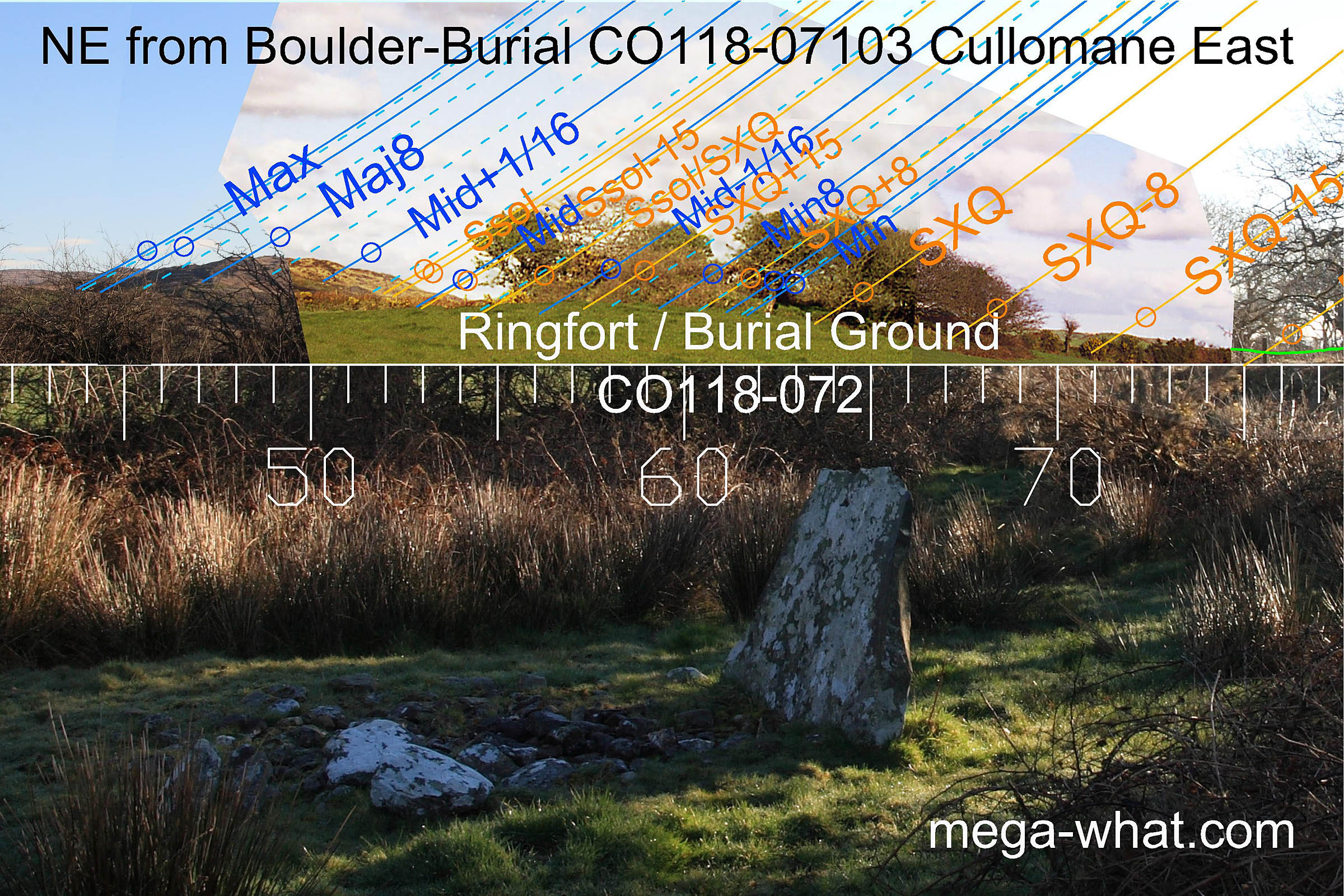 Dromore hill provides useful markers to the north-east.
The major end of the lunisticeLunistices are the most northerly and southerly moons of the month. The lunar equivalent of solstices - more.
range occurs at its intersection with a more distant hill, though the most extreme position is actually at a notch on this further horizon.
The hill's top marks an eighth and a prominent step at its east base marks the the position of lunar midpoint and a half-month off the summer solstice.
Unfortunately, Glanatnaw Hill is obscured by the built-up profile of a burial ground and the trees now growing on it.
Inchybegga hilltop, though low on the horizon, marks a half-month south of the summer cross-quarters.
Dromore hill provides useful markers to the north-east.
The major end of the lunisticeLunistices are the most northerly and southerly moons of the month. The lunar equivalent of solstices - more.
range occurs at its intersection with a more distant hill, though the most extreme position is actually at a notch on this further horizon.
The hill's top marks an eighth and a prominent step at its east base marks the the position of lunar midpoint and a half-month off the summer solstice.
Unfortunately, Glanatnaw Hill is obscured by the built-up profile of a burial ground and the trees now growing on it.
Inchybegga hilltop, though low on the horizon, marks a half-month south of the summer cross-quarters.
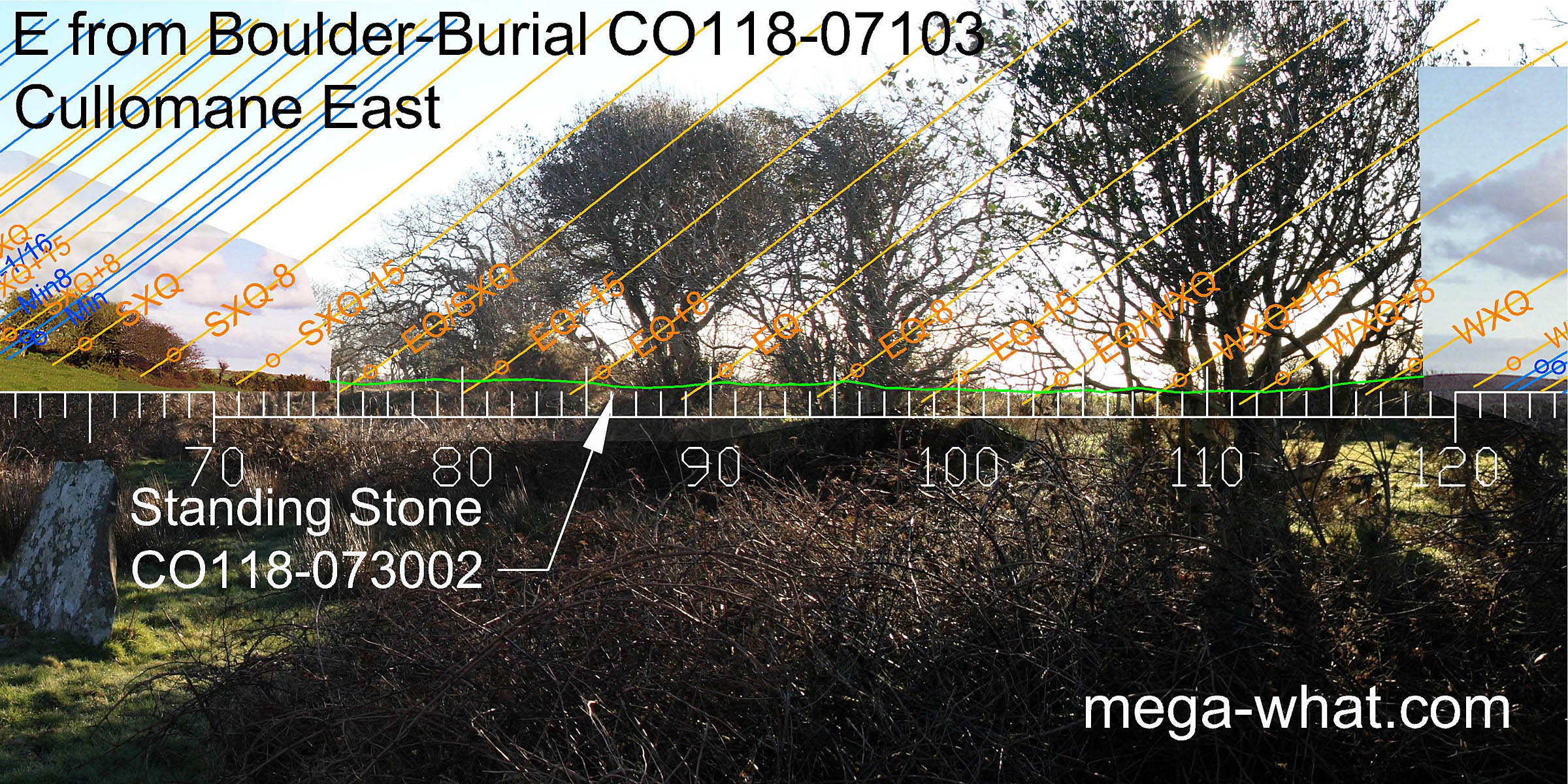 Views to the east are obscured. The nearby Standing Stone CO118-07302 is probably a later monument
but would be visible on the horizon at azimuth 86°, declination about 2°.
Five Stone Circle CO118-07301 is also about 200m away at 100°.
Views to the east are obscured. The nearby Standing Stone CO118-07302 is probably a later monument
but would be visible on the horizon at azimuth 86°, declination about 2°.
Five Stone Circle CO118-07301 is also about 200m away at 100°.
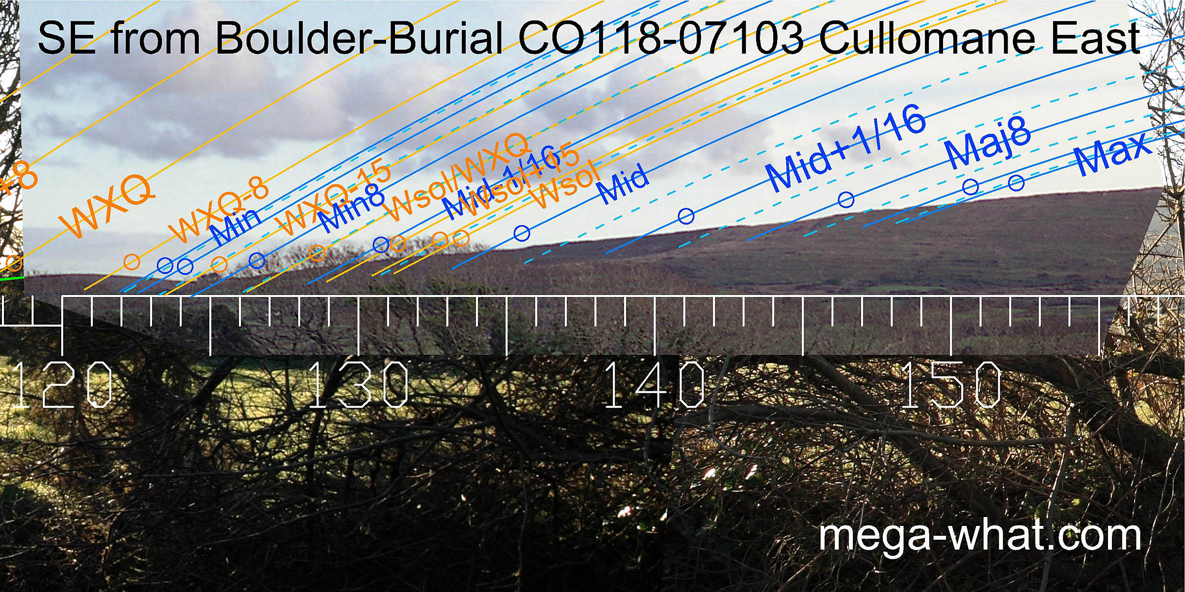 To the south-east the quarter-month and half-month south of the winter cross-quarters are marked by the top and south base of a hill.
Then there is a long fairly straight slope which at first does not look too promising.
However, there are markers to be found on it and they are clearer to the naked eye than the photograph might suggest.
The lunar minor eighth is at a small top just above the basal dip and its complement, the major eighth is at a step further up the slope.
The lunar extreme is marked by another step which is actually a small vertical rock face.
To the south-east the quarter-month and half-month south of the winter cross-quarters are marked by the top and south base of a hill.
Then there is a long fairly straight slope which at first does not look too promising.
However, there are markers to be found on it and they are clearer to the naked eye than the photograph might suggest.
The lunar minor eighth is at a small top just above the basal dip and its complement, the major eighth is at a step further up the slope.
The lunar extreme is marked by another step which is actually a small vertical rock face.
Similar use of a long slope in the south-east quadrant may be seen at:
- Coorleigh South Mass Rock / Boulder-Burial.
- Glanbrack Five Stone Circle & Stone Pair.
This is the third and last Boulder-Burial directly inland from the head of Dunmanus Bay. Coolcoulaghta is the first and quite large. Ballycommane is the second, a similar size to this one and also of quartzite.
This is also the west-most and probably the earliest of a local group of monuments that utilise these same horizons in slightly different ways from positions about 200m apart. The nearest two of these are the Five Stone Circle and its nearby Standing Stone already mentioned above.
A further variant usage of Glanatnaw Hill in the north-east may be seen from Inchybegga which is 1.5km nearer to it.
A Stone Axe was found, not far from here, in 2005, See Details
References
- Archaeological Survey of Ireland, record details. www.archaeology.ie/archaeological-survey-ireland
- POWER, D. et al. 1992 Archaeological Inventory of County Cork, Volume 1: West Cork. Dublin: Stationary Office. p31, no.111.