
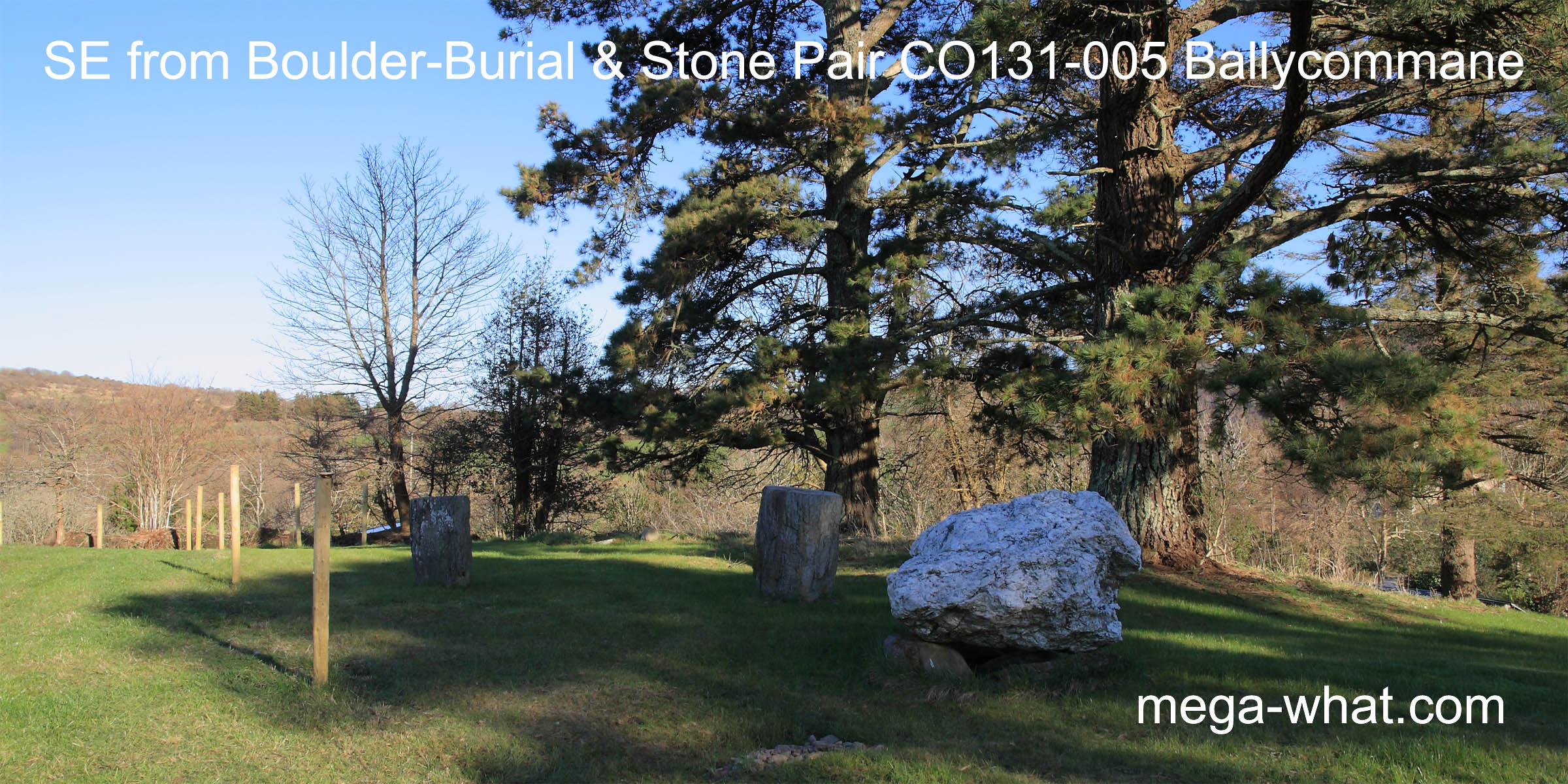
 The Standing Stone Pair & Boulder-Burial at Ballycommane, near Durrus have been excavated & restored but their age could not be determined.
They are now in the garden of Ballycommane House. The east and south-east are obscured by trees.
The Standing Stone Pair & Boulder-Burial at Ballycommane, near Durrus have been excavated & restored but their age could not be determined.
They are now in the garden of Ballycommane House. The east and south-east are obscured by trees.
The site offers approximate symmetry with a high ridge to the south [Pic] sloping away to lower points in the south-east and south-west. Single hills occupy both north-east and north-west. North is roughly indicated by a dip [Pic]. The more southerly stone of the pair is basically square and set with its faces N, S, E & W.
![[Pic]](Ballycommane-S.jpg)
![[Pic].](Ballycommane-N.jpg)
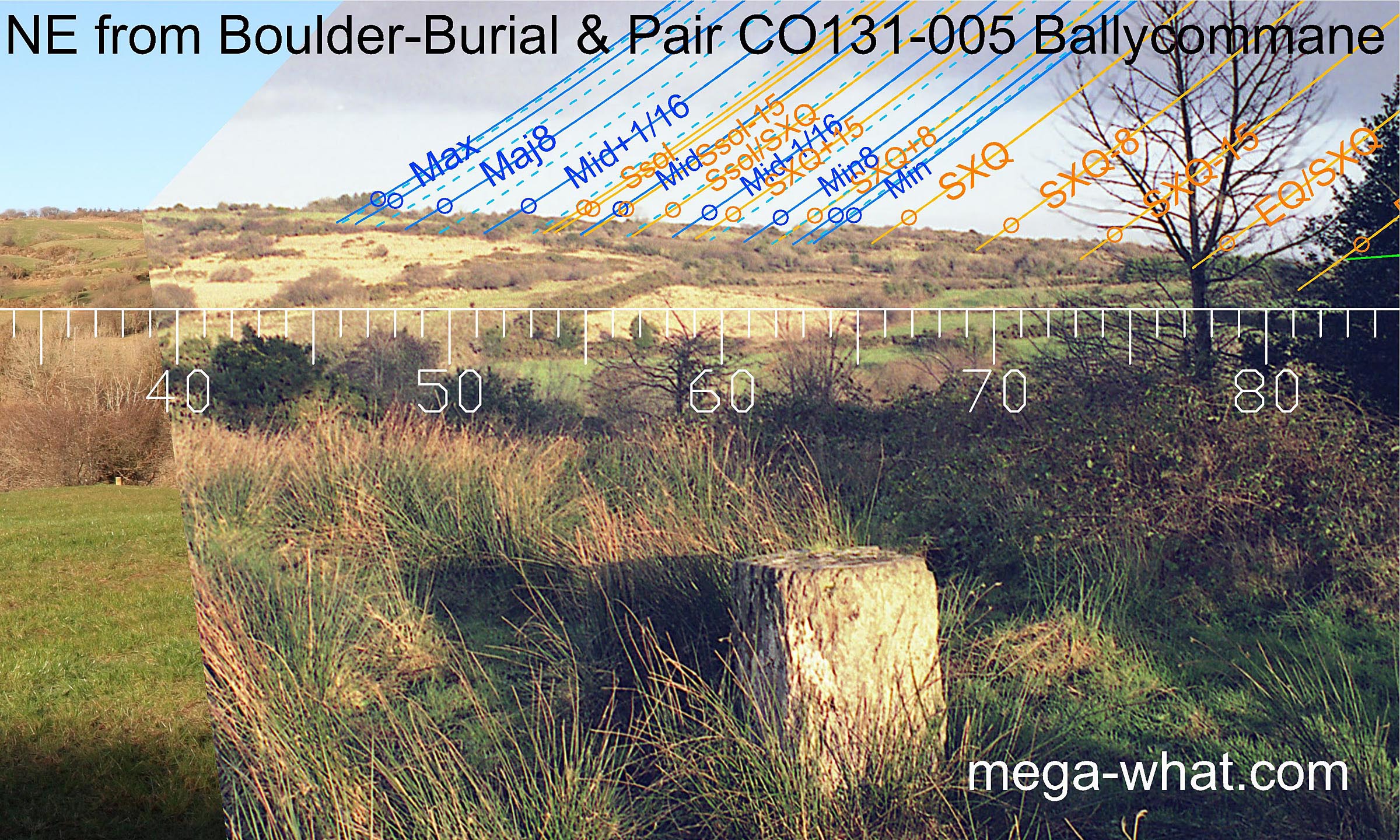
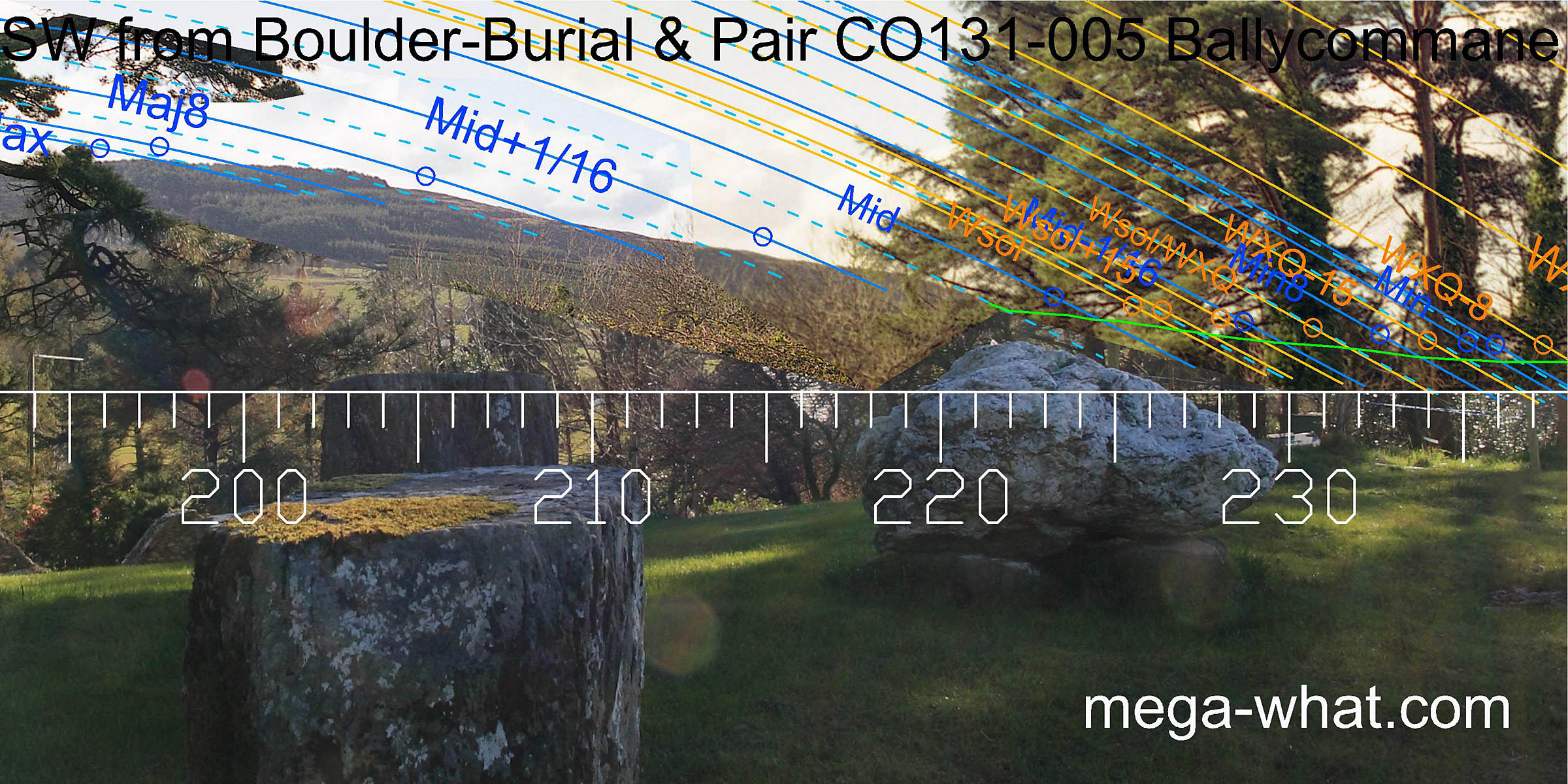 Axially, the Pair indicates the south-western hill which marks the position of most southerly moonset.
The Boulder-Burial, perhaps less obviously, has a similar orientation [Pic].
The ridge falls to a saddle which marks the minor end of the lunisticeLunistices are the most northerly and southerly moons of the month. The lunar equivalent of solstices - more.
cycle but unfortunately, this sector of the horizon is largely obscured.
Axially, the Pair indicates the south-western hill which marks the position of most southerly moonset.
The Boulder-Burial, perhaps less obviously, has a similar orientation [Pic].
The ridge falls to a saddle which marks the minor end of the lunisticeLunistices are the most northerly and southerly moons of the month. The lunar equivalent of solstices - more.
cycle but unfortunately, this sector of the horizon is largely obscured.
![[Pic].](Ballycommane-SWaxB.jpg)
Clearly, the full length of this western slope has been fitted to the lunistice range to spread it out over more azimuth, enabling increased accuracy. Green lines approximate hidden horizon segments.
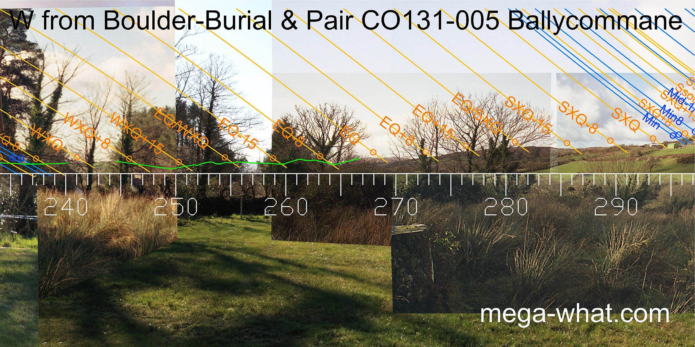 Due west, a pair of distant hills may be seen with the equinoctial sunset falling in the notch between them.
The halfway point between the equinox and the summer cross-quarters are on top of the next nearer hill.
Due west, a pair of distant hills may be seen with the equinoctial sunset falling in the notch between them.
The halfway point between the equinox and the summer cross-quarters are on top of the next nearer hill.
 The cross-quarter itself is at the foot of the north-western hill. This north-western skyline is not exactly rugged but whatever humps and bumps it has do seem to have been made use of.
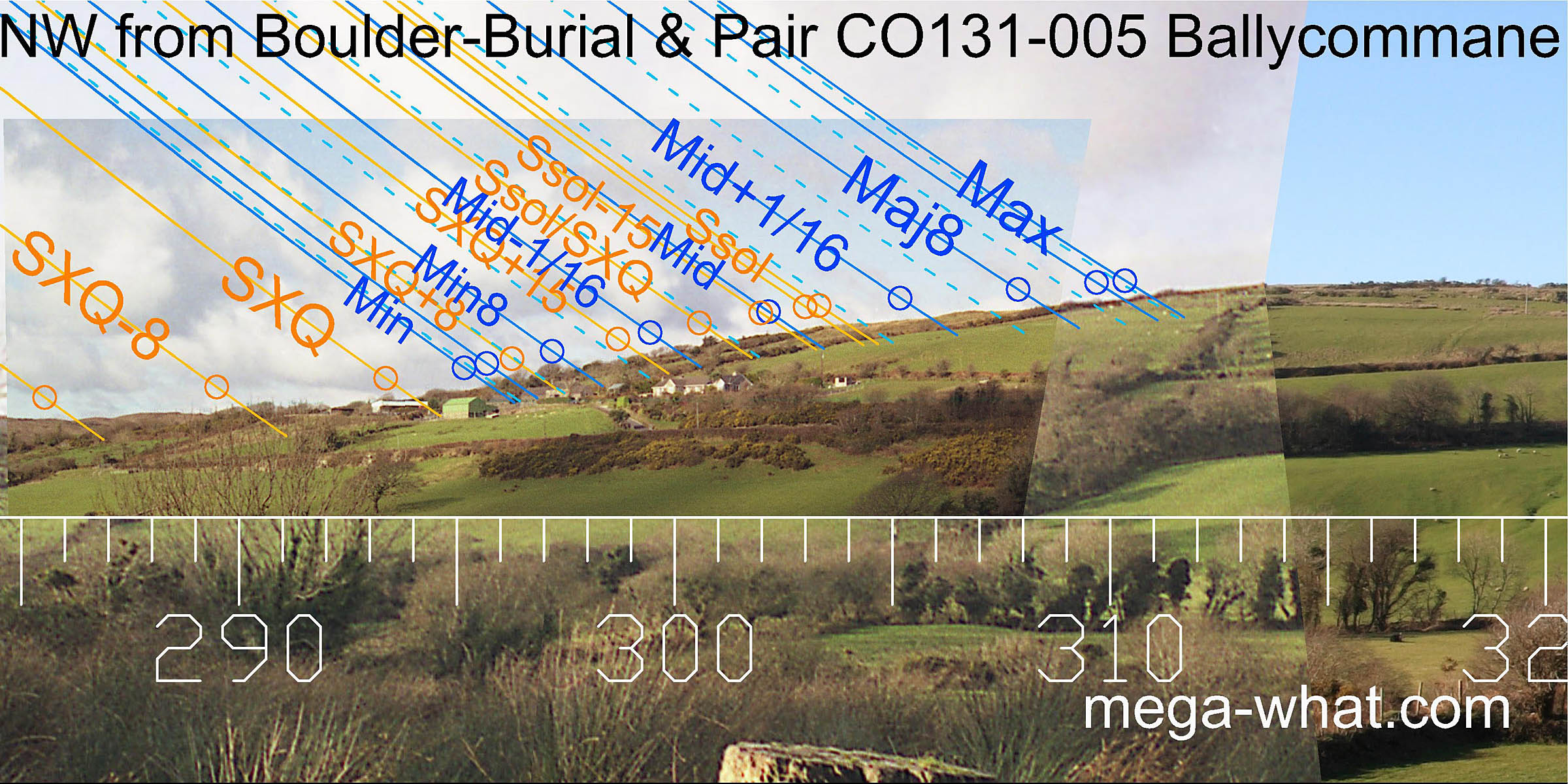
 The north-eastern hill, now covered in scrub, seems even plainer, perhaps that is why the more northerly stone of the pair is set
so that its lozenge shape indicates the minor end of the lunistice range in this direction.
The north-eastern hill, now covered in scrub, seems even plainer, perhaps that is why the more northerly stone of the pair is set
so that its lozenge shape indicates the minor end of the lunistice range in this direction.
The site was excavated in 1989. No human or dateable remains were found though there was a small cist near the north-east stone of the pair and some sort of ritual deposition under the boulder (O'Brien 1992). More interesting from an archaeoastronomical perspective are the stake-hole at the east corner of the boulder and the two furrows.
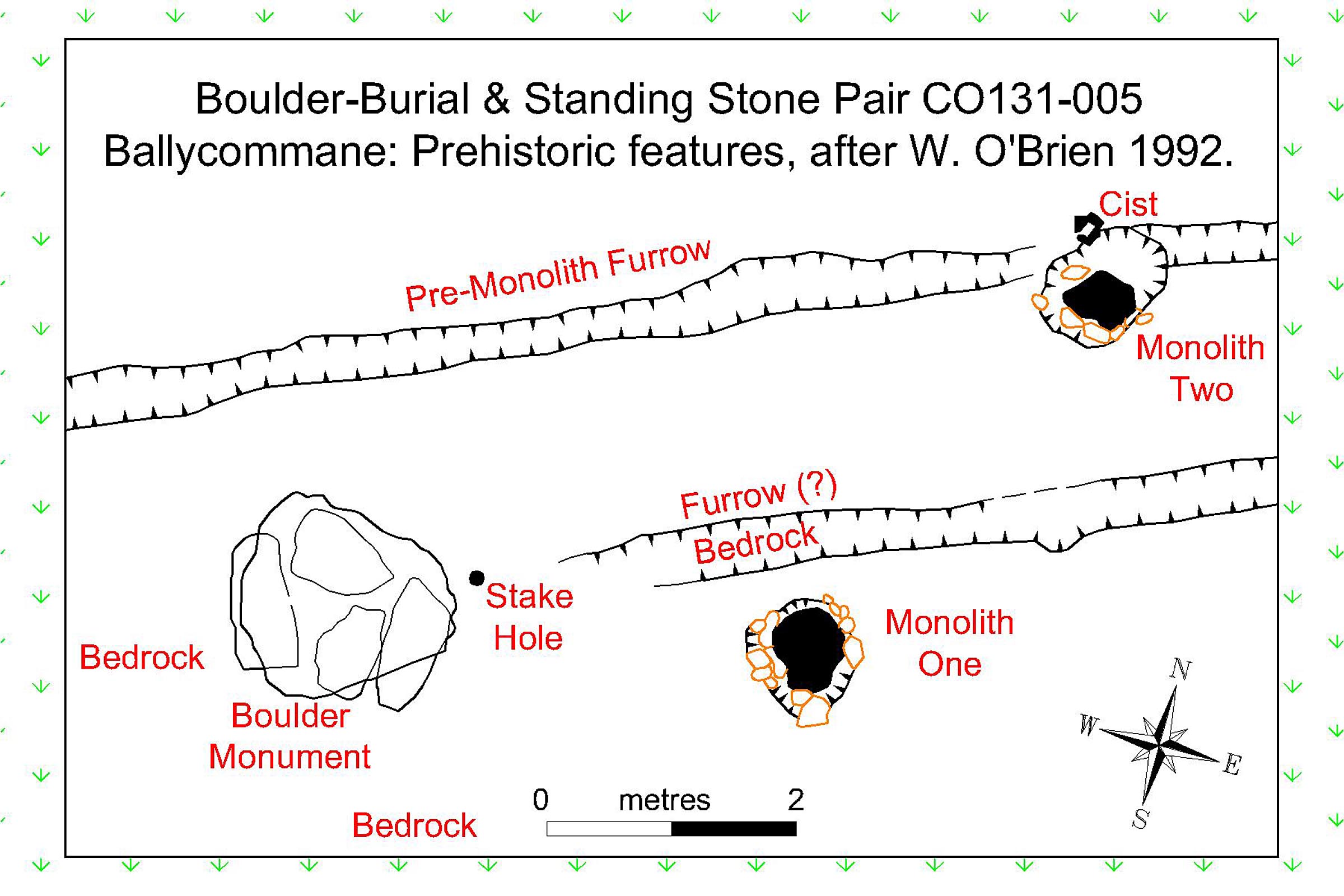
A suggested scenario is as follows: The southern furrow was dug as a base marker for observations during the setting out process for the boulder-monument, with the stake-hole indicating the final decision as to its position. Later, the stone-pair people came along and, knowing what the boulder was for and why it was there, decided to build their own monument at the site. They dug the northern furrow as a base marker for their own observations and the northern stone is at what they regarded as the optimal position.
The furrows run the way they do because moving along them would make a very small difference to the distant horizons in those directions whilst having a significant effect on the astronomical effectiveness of nearer features in more perpendicular directions. Similar furrows have been found at Maughanasilly and possibly Kealkill.
Both these monuments seem to be members of local groups or series.
This Boulder-Burial is the central one of three in a penetration inland from Dunmanus Bay:
- Coolcoulaghta is 4km to the south-west.
- Cullomane East is 6.1km to the north-east.
- Parkana is 2.2km away to the north-east.
- Coolcoulaghta is 6.3km to the south-west.
References
- Archaeological Survey of Ireland, record details. www.archaeology.ie/archaeological-survey-ireland
- O'BRIEN, WILLIAM 1992 Boulder-Burials: A Later Bronze Age Megalith Tradition in South-West Ireland. Journal of the Cork Historical and Archaeological Society 9:11-35.
- O'BRIEN, BILLY 1989 Cork 1989:009 Ballycommane. www.excavations.ie
- Ó'NUALLÁIN, SEÁN 1978 Boulder-Burials. Proceedings of the Royal Irish Academy 78c:75-114, p93, no.27.
- Ó'NUALLÁIN, SEÁN 1988 Stone Rows in the South of Ireland. Proceedings of the Royal Irish Academy 88c:179-256, p248, no.137.
- POWER, D. et al. 1992 Archaeological Inventory of County Cork, Volume 1: West Cork. Dublin: Stationary Office. p38:no.170, p29:no.96.