
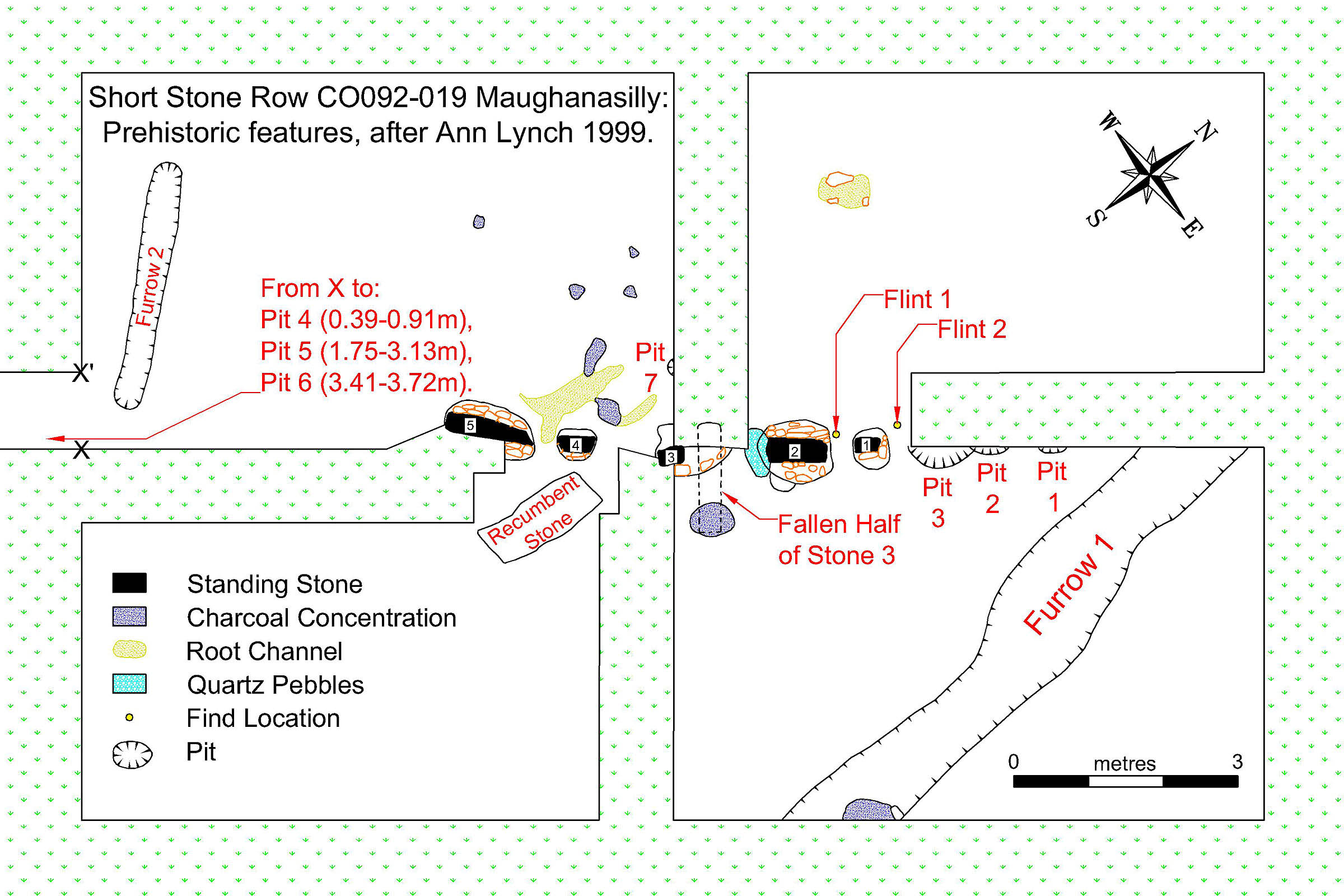
 There are five Standing Stones and one prostrate one. It was excavated in 1977 (Lynch 1999, 1981, 1979) and no traces of any burial or ritual deposit were discovered.
Two small flint flakes were found and charcoal samples gave a probable construction date of 1678-1438 cal B.C.
This row also featured in two earlier and inconclusive archaeoastronomical investigations of monument axes (Lynch 1982, Ruggles 1999, 1996, 1995, 1994).
Two possible hut sites were found a little to the north-east, but not in sight (Lynch 1999).
There are five Standing Stones and one prostrate one. It was excavated in 1977 (Lynch 1999, 1981, 1979) and no traces of any burial or ritual deposit were discovered.
Two small flint flakes were found and charcoal samples gave a probable construction date of 1678-1438 cal B.C.
This row also featured in two earlier and inconclusive archaeoastronomical investigations of monument axes (Lynch 1982, Ruggles 1999, 1996, 1995, 1994).
Two possible hut sites were found a little to the north-east, but not in sight (Lynch 1999).
The three pits at either end of the row may represent the positions of temporary markers of some sort. Note the two furrows. Also note that the row is not straight. This is deliberate and cleverly so.
 South is indicated by a small but prominent local highpoint [Pic].
![[Pic].](Maughanasilly-S.jpg)
North is in a dip [Pic].
![[Pic].](Maughanasilly-N.jpg)
The eastern luni-solar zone spans a rise, the western one a dip.
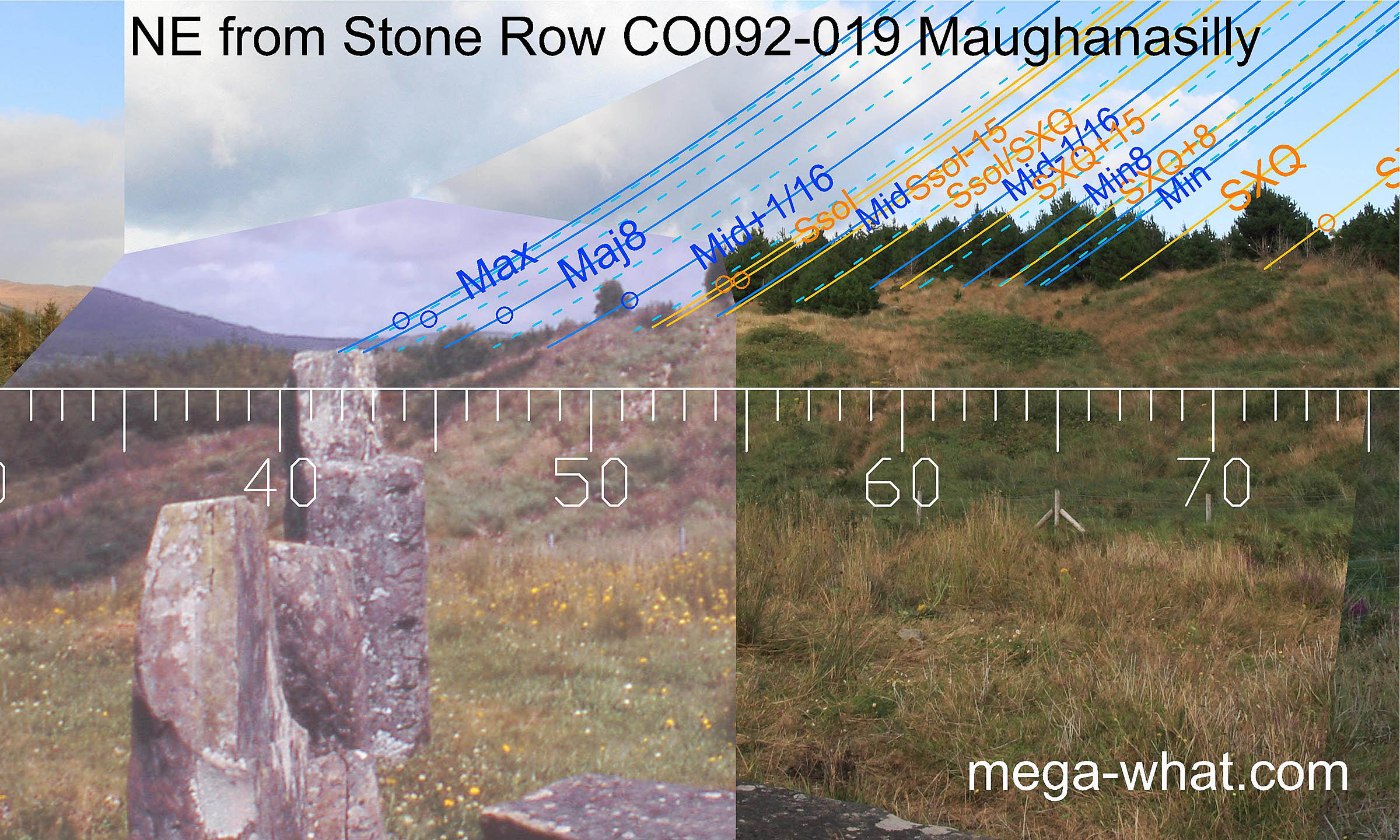 The north-eastern profile is increasingly obscured by forestry. The local high point and its intersects with further slopes are the most position sensitive part of the horizon.
Stone 2 is the tallest and, with the stones either side of it, makes a bi-directional pointer towards major standstillLunistice positions vary cyclically over an 18.6 year period but are fairly static for more than a year at either end of the range winter solstice full moon rise in a distant dip to the north-east . . .
 . . . and major standstillLunistice positions vary cyclically over an 18.6 year period but are fairly static for more than a year at either end of the range
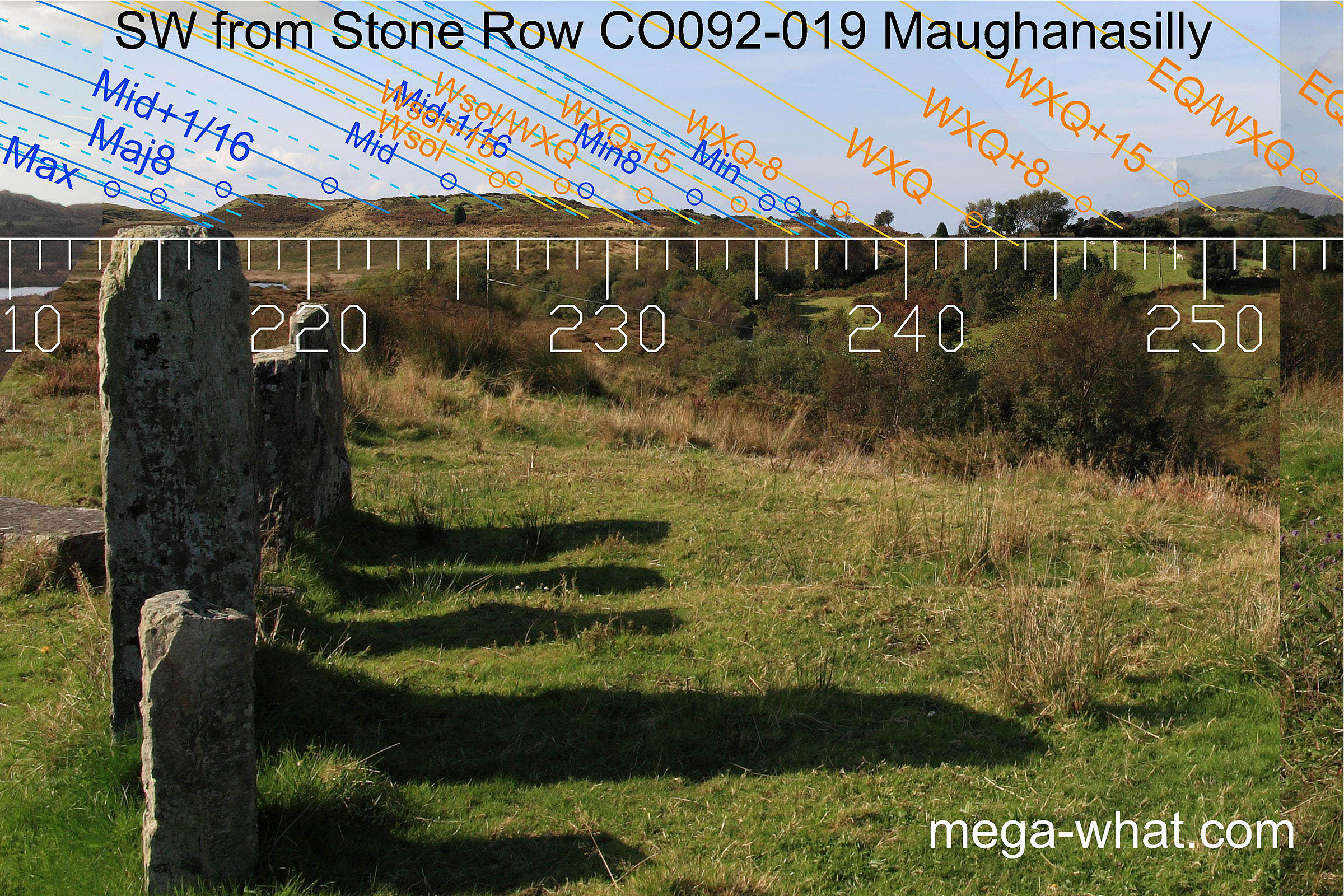
summer solstice full moon set at a dip in the south-west.
In this direction virtually every high & low point on the horizon makes a useful marker.
. . . and major standstillLunistice positions vary cyclically over an 18.6 year period but are fairly static for more than a year at either end of the range
summer solstice full moon set at a dip in the south-west.
In this direction virtually every high & low point on the horizon makes a useful marker.
So, being roughly perpendicular to the row axis, furrow 2 is well placed to be a provisional marker for optimising position in relation to the south-west and north-east horizons. Movement along the furrow would have a significant effect on the accuracy of the axial horizons while making no significant difference to the non-axial ones.
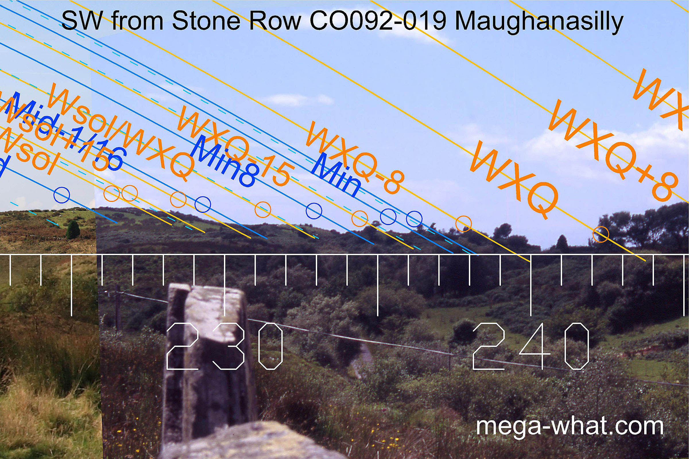 At the south-west end of the row, stone 5 is a thin flat slab at a distinct angle to the rest of the row.
It indicates a sixteenth part of the lunisticeLunistices are the most northerly and southerly moons of the month. The lunar equivalent of solstices - more.
range in both directions. To the south-west, in a dip, the sixteenth part on the minor side of the midpoint . . .
At the south-west end of the row, stone 5 is a thin flat slab at a distinct angle to the rest of the row.
It indicates a sixteenth part of the lunisticeLunistices are the most northerly and southerly moons of the month. The lunar equivalent of solstices - more.
range in both directions. To the south-west, in a dip, the sixteenth part on the minor side of the midpoint . . .
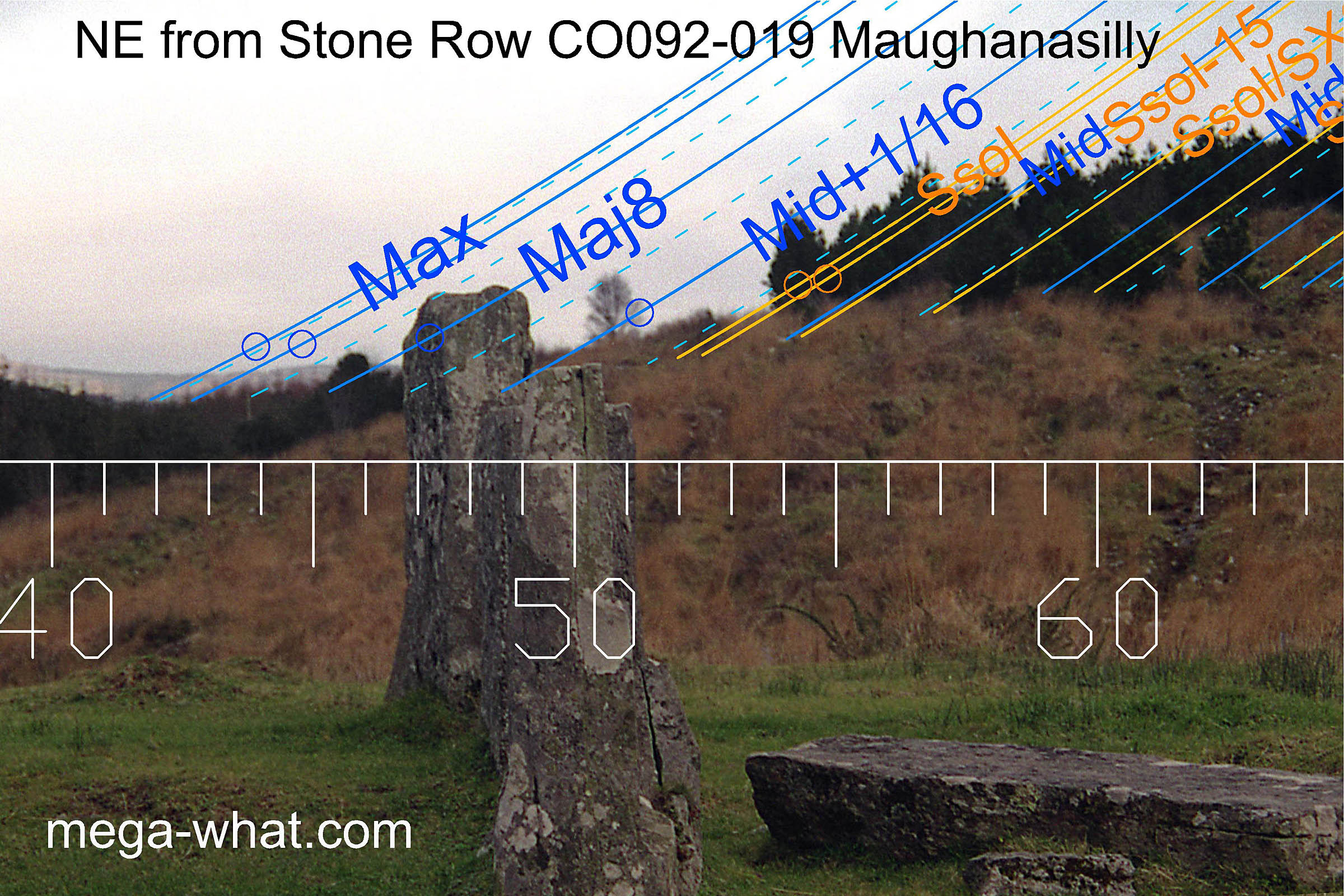 . . . and to the north-east, at the intersect of distant and near horizons, the sixteenth part on the major side of the midpoint.
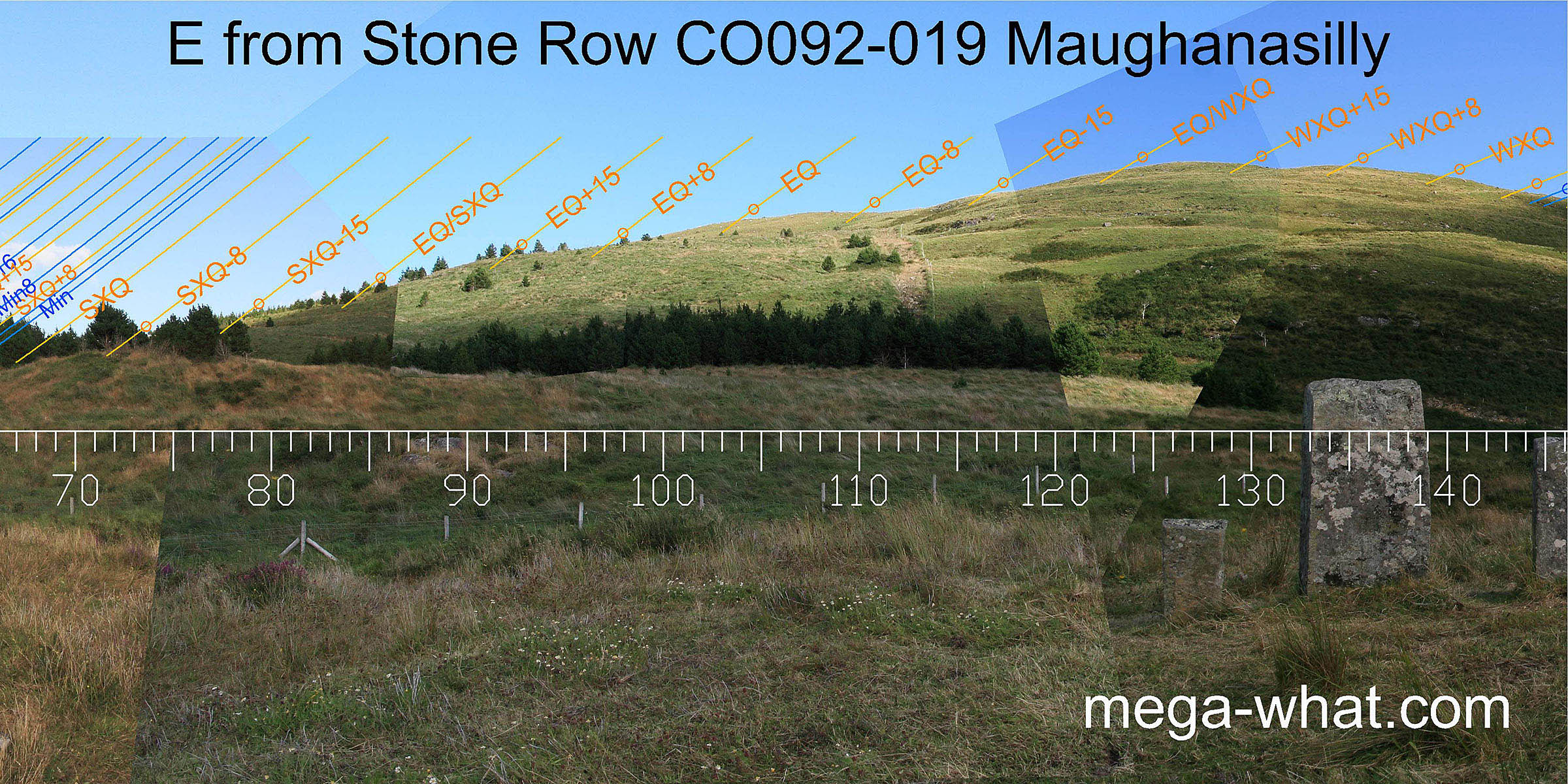 The eastern horizon is dominated by nearby Knockbreteen, which is both high and close.
This horizon profile is not very rugged but care has been taken to fit it to the celestial patterns as usefully as possible. Especially the period centred on the equinox.
The eastern horizon is dominated by nearby Knockbreteen, which is both high and close.
This horizon profile is not very rugged but care has been taken to fit it to the celestial patterns as usefully as possible. Especially the period centred on the equinox.
 In the far south-east, the lunisticeLunistices are the most northerly and southerly moons of the month. The lunar equivalent of solstices - more.
range is a better fit than might be expected on such a profile. There is also a natural marker due south [Pic].
In the far south-east, the lunisticeLunistices are the most northerly and southerly moons of the month. The lunar equivalent of solstices - more.
range is a better fit than might be expected on such a profile. There is also a natural marker due south [Pic].
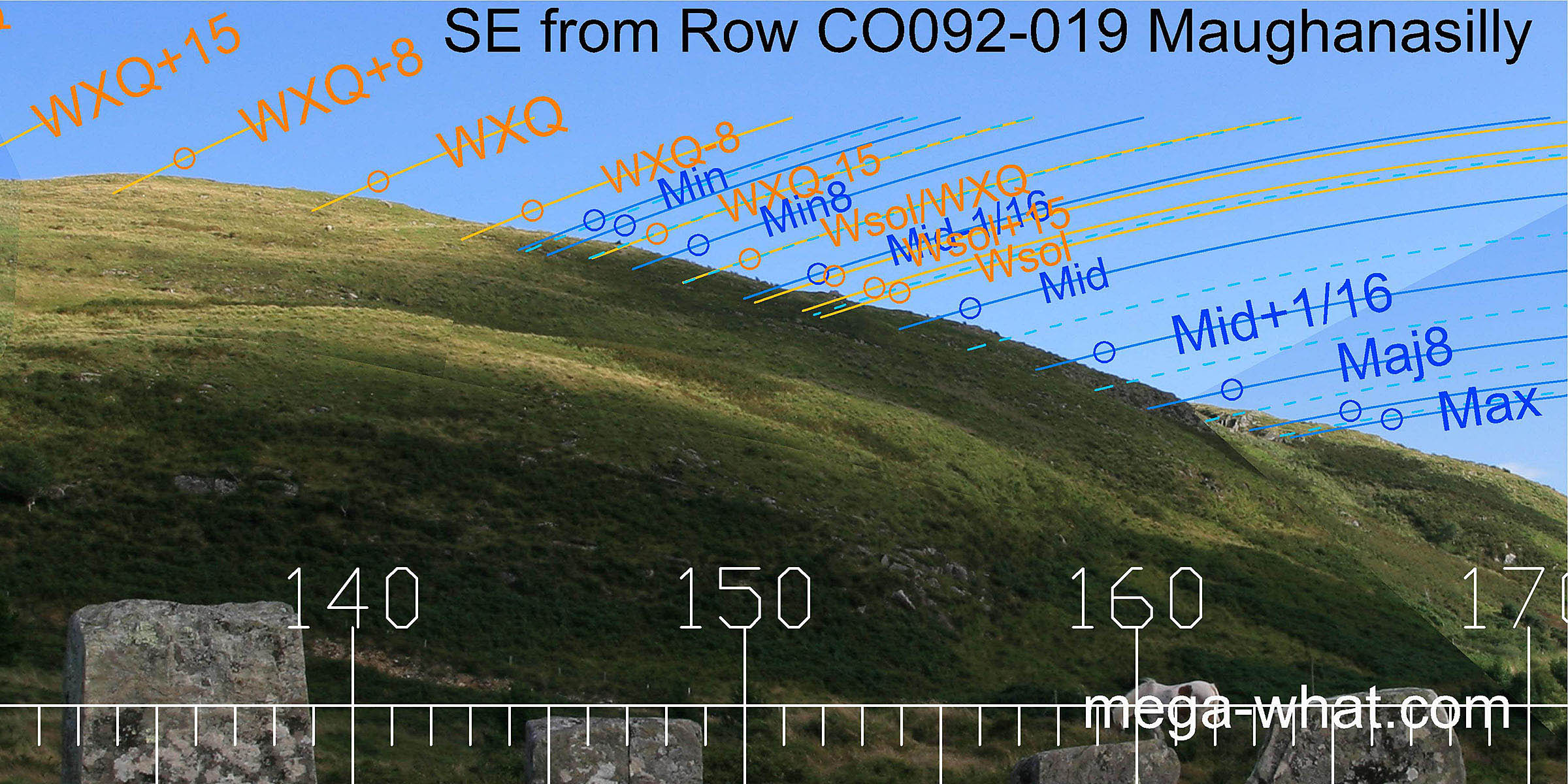
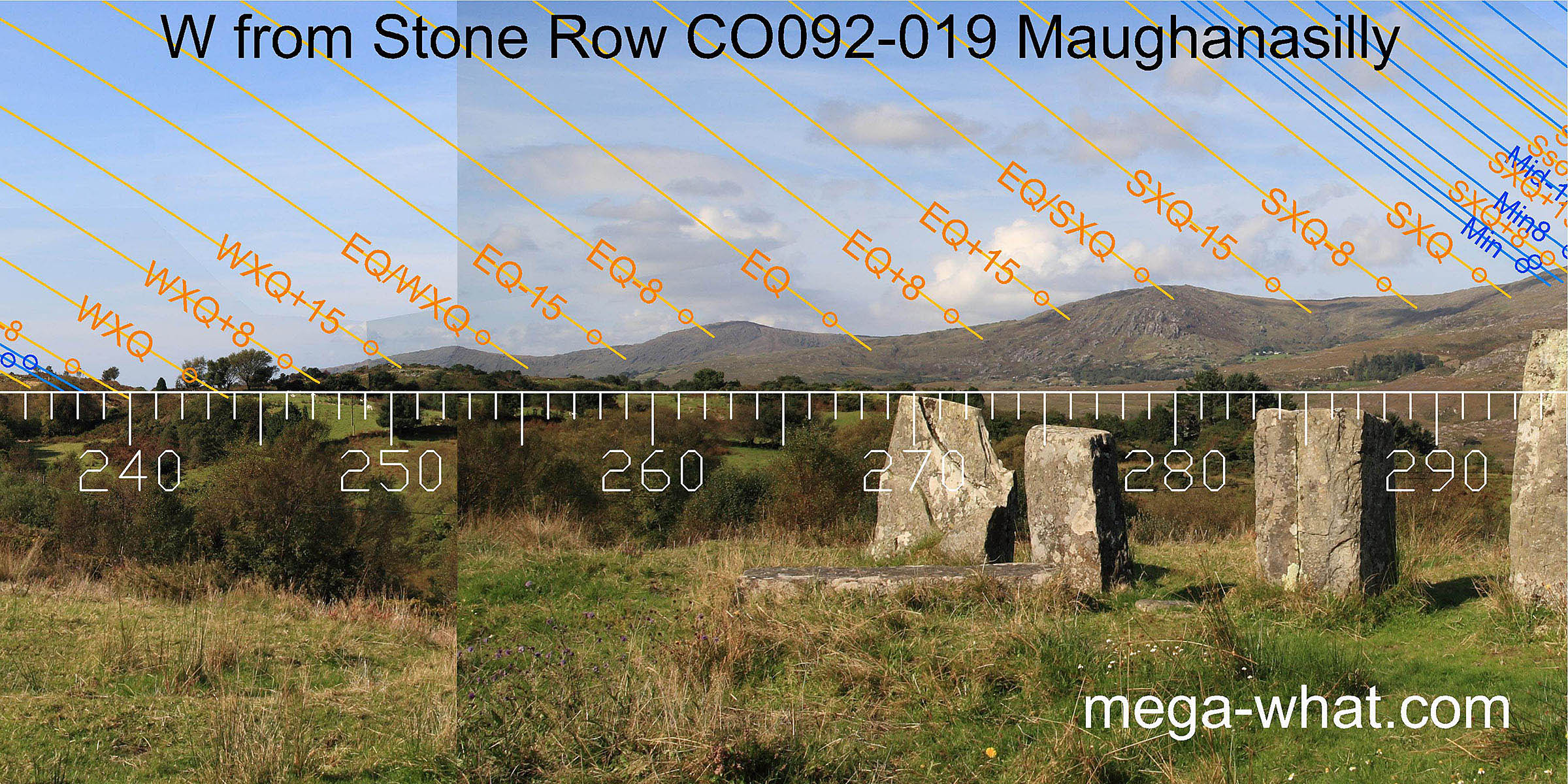 To the west, winter cross-quarters are at the foot of the first distant hill and summer cross-quarters are at the foot of the penultimate top.
The equinox / cross-quarter midpoints are in a dip and on a top. The equinox is in a dip.
To the west, winter cross-quarters are at the foot of the first distant hill and summer cross-quarters are at the foot of the penultimate top.
The equinox / cross-quarter midpoints are in a dip and on a top. The equinox is in a dip.
Furrow 1 runs roughly north-south and is well sited to be a provisional marker for optimising position in relation to the east and west horizons. Because the western hills are more distant, lateral movement along the furrow would have a larger effect on the eastern horizon than the western one.
Excavation showed the recumbent stone to be neither a natural feature nor a later addition to the site. It is placed so that anyone walking up to it and standing with toes touching its edge is looking straight at the equinox and it may be seen as a permanent replacement for furrow 1 because they are parallel to each other.
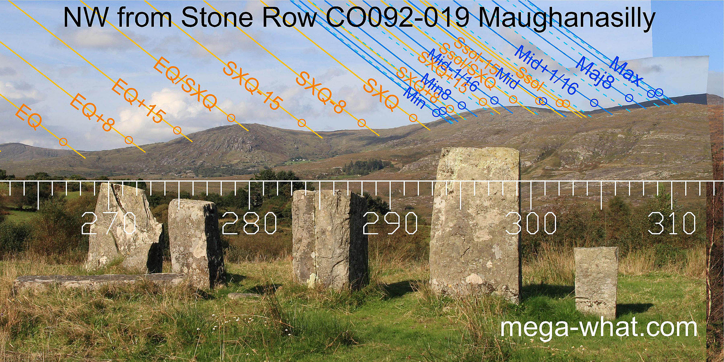 To the north-west, summer sunsets are draped over the hill from the cross-quarter at the south foot to the solstice at the north foot. The midpoint in time between them is on the hilltop.
- Illane Five Stone Circle is 1km north (10°)
- Derrynafinchin 11 Stone Circle is 4km north (5°) in the Borlin Valley
- Ardrah Stone Row is 5km south-east (145°) in the Mealagh Valley
- Canrooska Stone Row & Five Stone Circle are 11km west (267°) above Glengarriff
References
- Archaeological Survey of Ireland, record details. www.archaeology.ie/archaeological-survey-ireland
- LYNCH, ANN 1999 Excavation of a Stone Row at Maughanasilly, Co. Cork. Journal of the Cork Historical and Archaeological Society 104:1-20.
- LYNCH, ANN 1982 Astronomy and Stone Alignments in S.W. Ireland. In Archaeoastronomy in the Old World, edited by D. Heggie, pp.205-213. Cambridge: University Press.
- LYNCH, ANN 1981 Man and the Environment in South-West Ireland, 4000 BC-AD 800. BAR British Series 85. Oxford: British Archaeological Reports pp69-74.
- LYNCH, ANN 1979 Cork 1977-79:0015 Maughanasilly. www.excavations.ie
- O'NUALLÁIN, S. 1988 Stone Rows in the South of Ireland. Proceedings of the Royal Irish Academy 88c:179-256, p234, no.33.
- POWER, D. et al. 1992 Archaeological Inventory of County Cork, Volume 1: West Cork. Dublin: Stationary Office. p37, no.160.
- RUGGLES, C.L.N. 1999 Astronomy in Prehistoric Britain and Ireland. New Haven & London: Yale University Press. CKR63.
- RUGGLES, C.L.N. 1996 Stone Rows of Three or More Stones in South-West Ireland. Archaeoastronomy 21 (Journal of the History of Astronomy xxvii) S55-S71.
- RUGGLES, C.L.N. & Burl, H.A.W. 1995 Astronomical Influences on Prehistoric Ritual Architecture in North-Western Europe: The Case of the Stone Rows. Vistas in Astronomy 39:517-528. Oxford: Elsevier Science Ltd.
- RUGGLES, C.L.N. 1994 The Stone Rows of South-West Ireland: A First Reconnaissance. Archaeoastronomy 19 (Journal of the History of Astronomy xxv) S1-S20.