
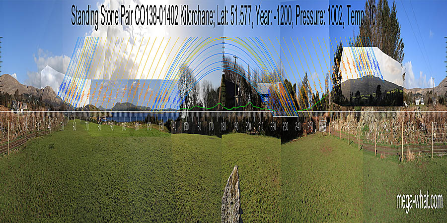
 This Standing Stone Pair is on the Sheep's Head peninsula, less than one kilometre south of the village of Kilcrohane.
North is indicated by Seefin but is to the left of the hilltop [Pic].
![[Pic].](Kilcrohane-N.jpg)
South is completely obscured [Pic].
![[Pic].](Kilcrohane-S.jpg)
Green lines approximate hidden horizon segments.
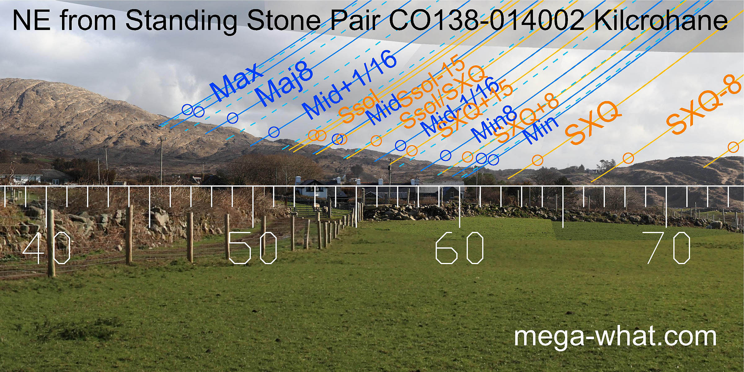 To the north-east, the south facing slope of Rosskerrig Mountain compresses the lunisticeLunistices are the most northerly and southerly moons of the month. The lunar equivalent of solstices - more.
range but its cragginess makes it a good measure.
The solstice and cross-quarter sunrises also get useful markers.
To the north-east, the south facing slope of Rosskerrig Mountain compresses the lunisticeLunistices are the most northerly and southerly moons of the month. The lunar equivalent of solstices - more.
range but its cragginess makes it a good measure.
The solstice and cross-quarter sunrises also get useful markers.
The axes of the pair and of its stones point well to the north of lunar major standstillLunistice positions vary cyclically over an 18.6 year period but are fairly static for more than a year at either end of the range [Pic].
![[Pic].](Kilcrohane-NEax.jpg)
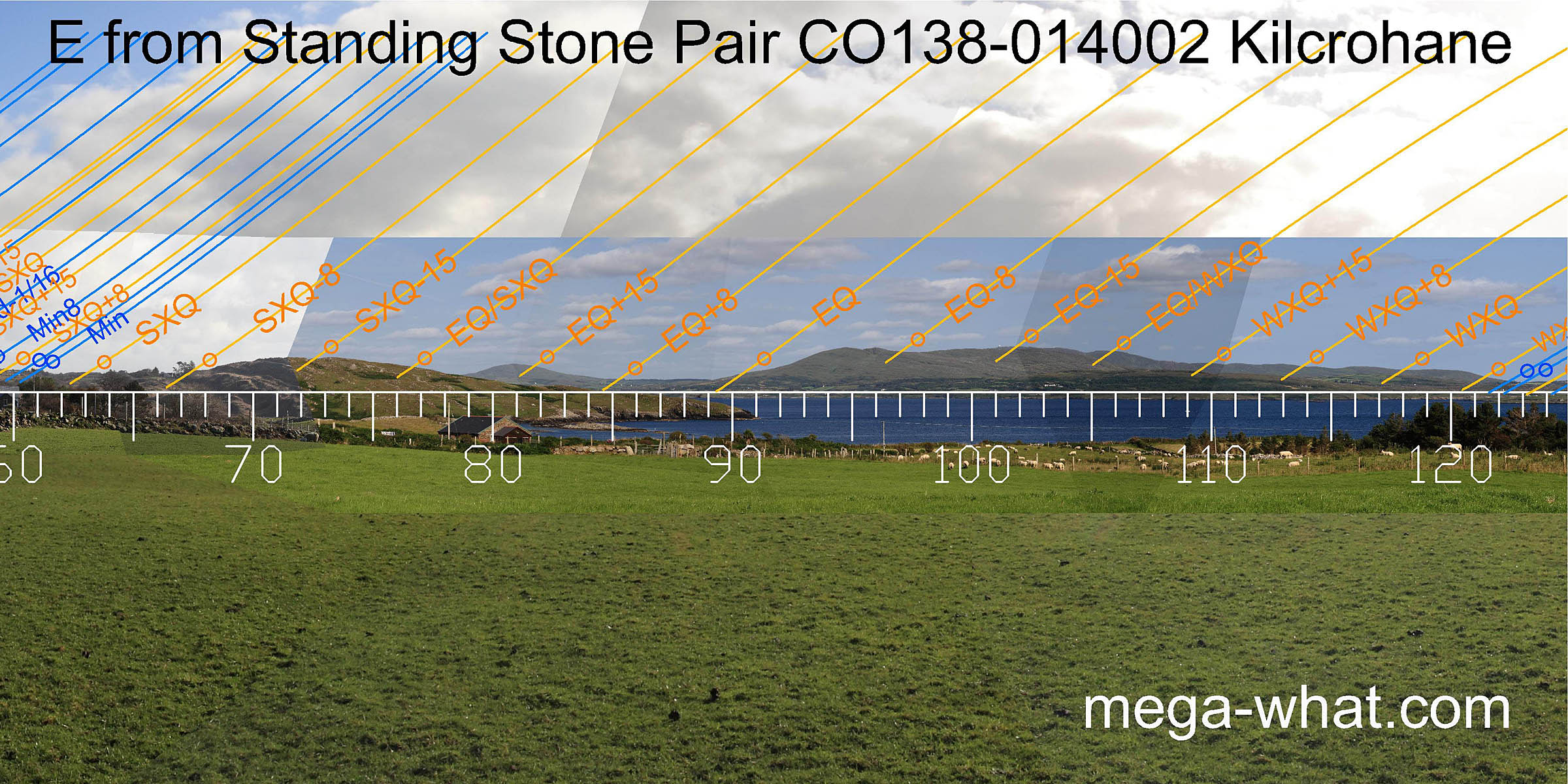 The east is also quite useful though perhaps less obviously so.
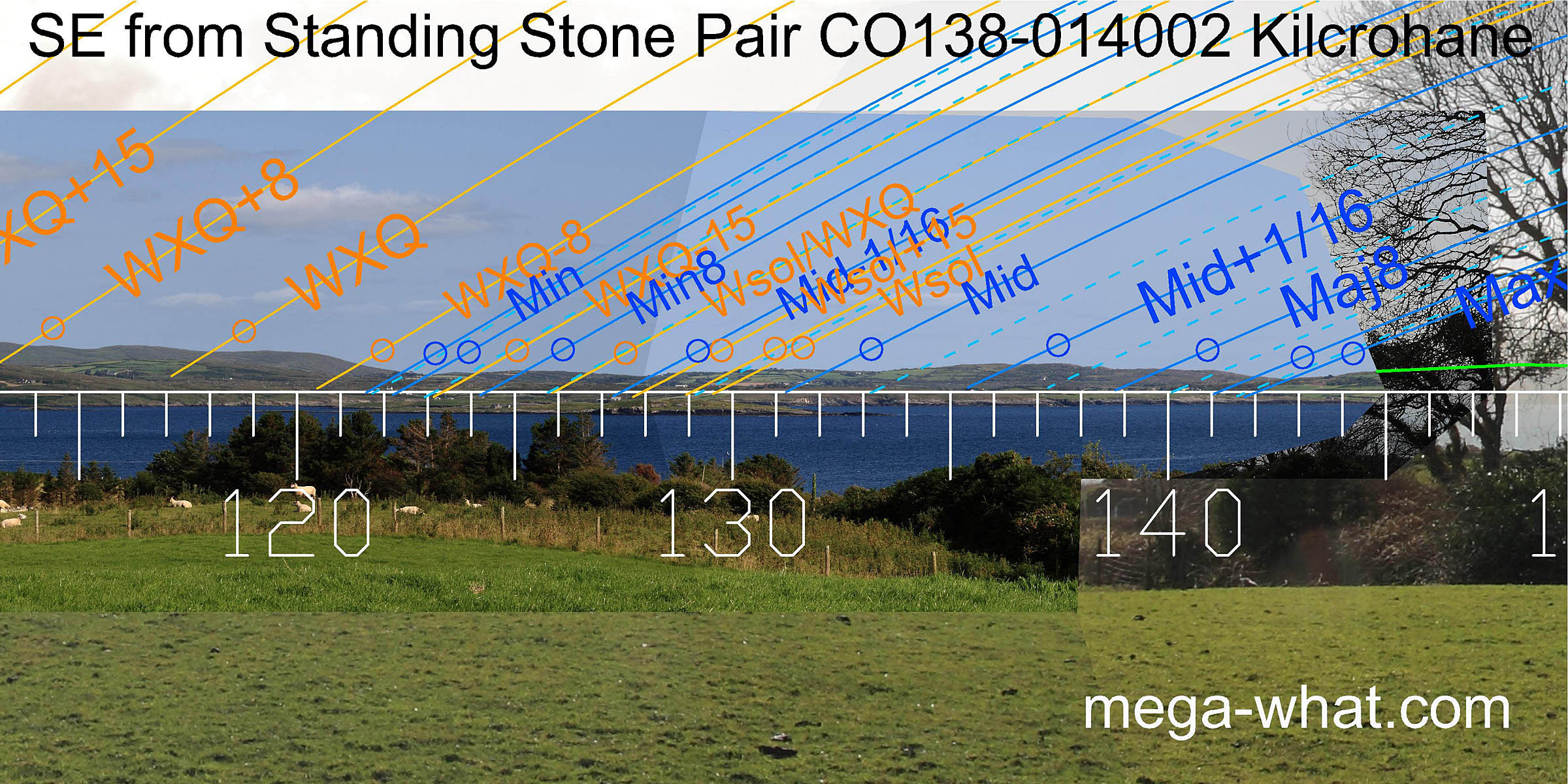 South-eastwards some low undulating hills provide markers for the winter sunrises and southerly lunisticeLunistices are the most northerly and southerly moons of the month. The lunar equivalent of solstices - more.
rises. There are four dips.
The first is the minor standstillLunistice positions vary cyclically over an 18.6 year period but are fairly static for more than a year at either end of the range
of the moon and the fourth is the major standstillLunistice positions vary cyclically over an 18.6 year period but are fairly static for more than a year at either end of the range.
The second is a lunar sixteenth. The third is about one diameter beyond the lunar midpoint.
South-eastwards some low undulating hills provide markers for the winter sunrises and southerly lunisticeLunistices are the most northerly and southerly moons of the month. The lunar equivalent of solstices - more.
rises. There are four dips.
The first is the minor standstillLunistice positions vary cyclically over an 18.6 year period but are fairly static for more than a year at either end of the range
of the moon and the fourth is the major standstillLunistice positions vary cyclically over an 18.6 year period but are fairly static for more than a year at either end of the range.
The second is a lunar sixteenth. The third is about one diameter beyond the lunar midpoint.
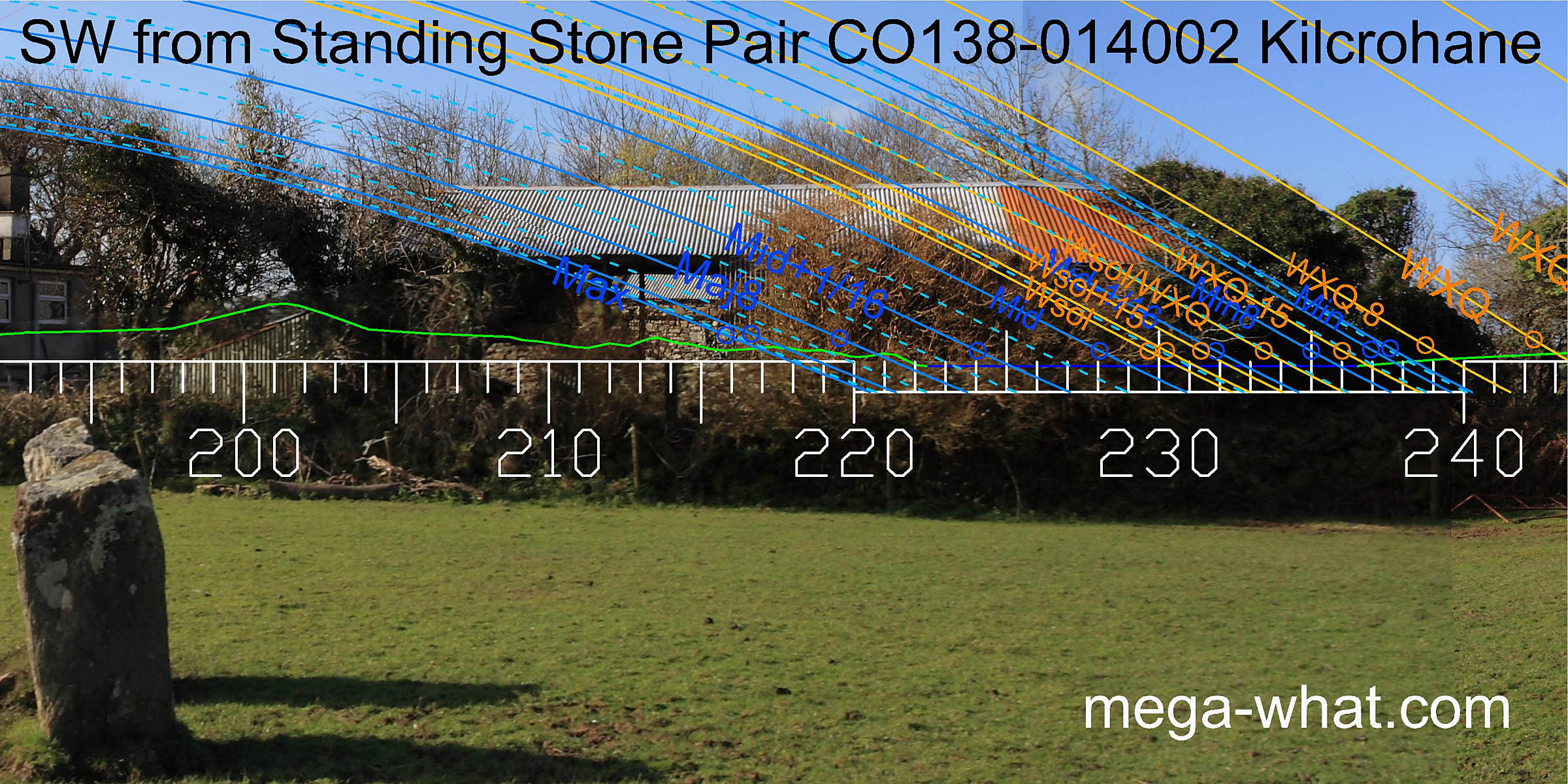 The south-west is almost totally obscured by trees and buildings butthe axis of the pair clearly points well to the south of the lunar major standstillLunistice positions vary cyclically over an 18.6 year period but are fairly static for more than a year at either end of the range.
Views should be of the lunisticeLunistices are the most northerly and southerly moons of the month. The lunar equivalent of solstices - more.
range spanning the sea horizon at the end of Dunmanus Bay, from the end of the Mizen peninsula to the coast of the Muintirvara peninsula.
The south-west is almost totally obscured by trees and buildings butthe axis of the pair clearly points well to the south of the lunar major standstillLunistice positions vary cyclically over an 18.6 year period but are fairly static for more than a year at either end of the range.
Views should be of the lunisticeLunistices are the most northerly and southerly moons of the month. The lunar equivalent of solstices - more.
range spanning the sea horizon at the end of Dunmanus Bay, from the end of the Mizen peninsula to the coast of the Muintirvara peninsula.
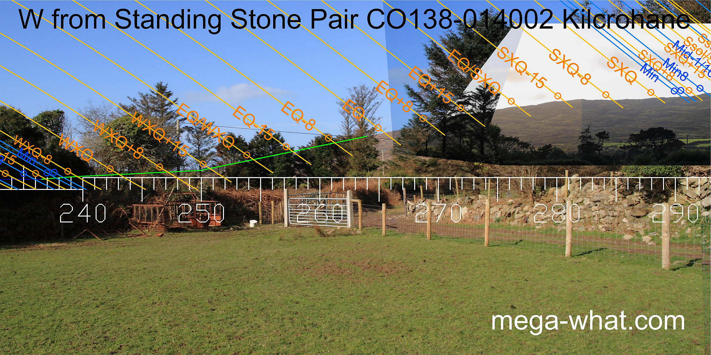 The view westwards is also obscured but should be the profile of Caher Mt's lower slopes.
From minor standstillLunistice positions vary cyclically over an 18.6 year period but are fairly static for more than a year at either end of the range
at the edge of Dunmanus Bay to minor standstillLunistice positions vary cyclically over an 18.6 year period but are fairly static for more than a year at either end of the range
at the basal step of the hilltop.
The view westwards is also obscured but should be the profile of Caher Mt's lower slopes.
From minor standstillLunistice positions vary cyclically over an 18.6 year period but are fairly static for more than a year at either end of the range
at the edge of Dunmanus Bay to minor standstillLunistice positions vary cyclically over an 18.6 year period but are fairly static for more than a year at either end of the range
at the basal step of the hilltop.
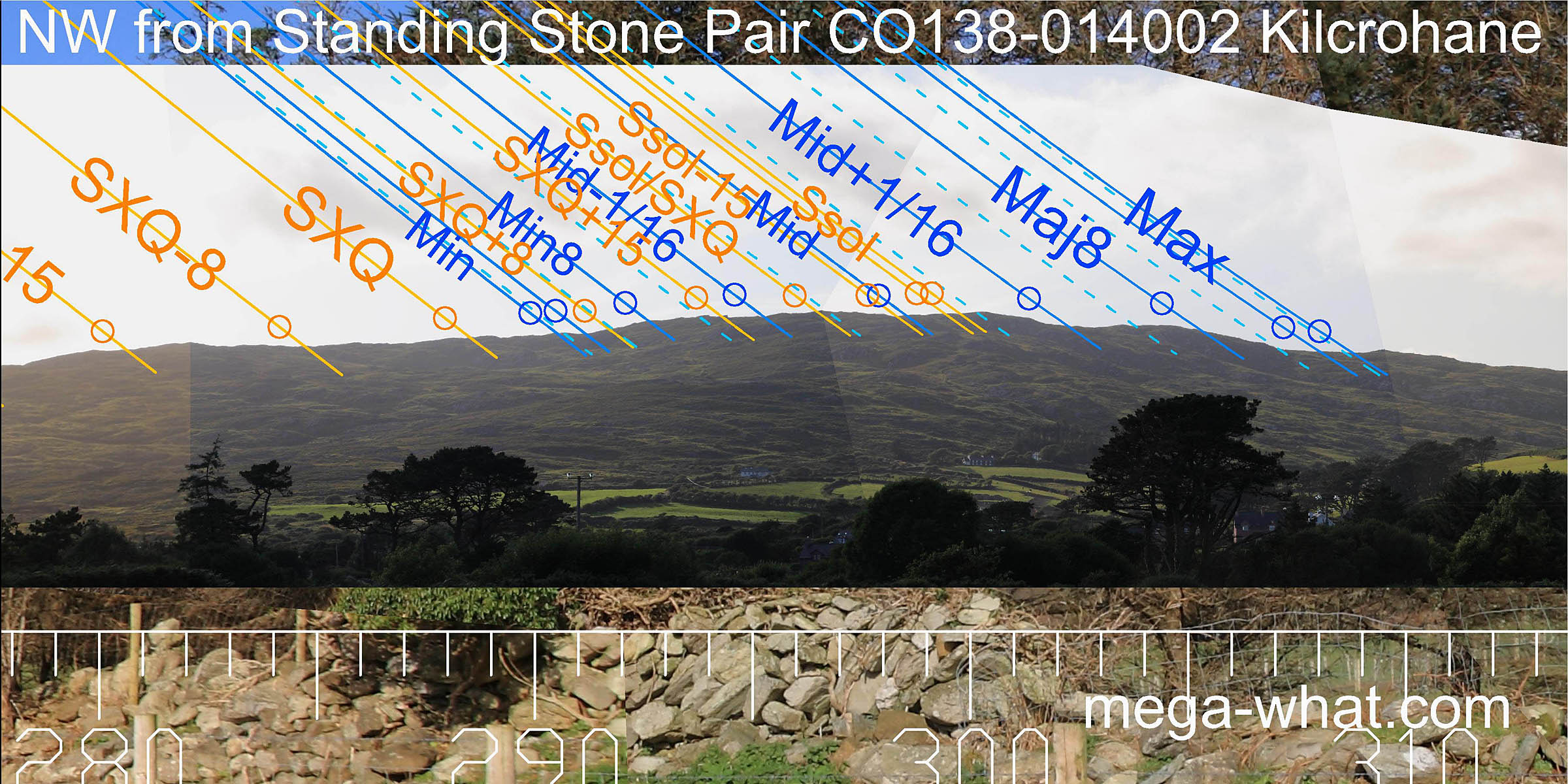 To the north-west, the upper parts of Caher Mountain were surveyed before the spruce trees grew tall enough to obscure it.
The hilltop has the lunar limits to either side and summer solstice sunset on its top.
To the north-west, the upper parts of Caher Mountain were surveyed before the spruce trees grew tall enough to obscure it.
The hilltop has the lunar limits to either side and summer solstice sunset on its top.
Site CO138-014001 is an earth & stone mound approx 15m diameter and 4m high amongst the farm buildings south-west of this pair - Power 1993:114, no.944.
Farranamanagh Stone Row is 1.2km to the north-north-east.
Other Stone Pairs with extreme axes are:
References
- Archaeological Survey of Ireland, record details. www.archaeology.ie/archaeological-survey-ireland
- Ó'NUALLÁIN, SEÁN 1988 Stone Rows in the South of Ireland. Proceedings of the Royal Irish Academy 88c:179-256, p248, no.140.
- POWER, D. et al. 1992 Archaeological Inventory of County Cork, Volume 1: West Cork. Dublin: Stationary Office. p41, no.192.