
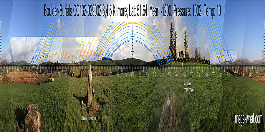
 Kilmore Boulder-Burials & Stone Row are 2km or so south of Drimoleague. They are just north-east of a low hilltop where three field boundaries meet.
South is on a hilltop [Pic].
![[Pic].](KilmoreBB-S.jpg)
North is on a hill in the centre of a block of high ground [Pic].
![[Pic].](KilmoreBB-N.jpg)
 The Stone Row is listed in the inventory as a single Standing Stone because, when recorded, the monument was buried in a field boundary and only one stone was visible.
Fair play then to the digger driver for recognising the significance of that which he left behind.
The Stone Row is listed in the inventory as a single Standing Stone because, when recorded, the monument was buried in a field boundary and only one stone was visible.
Fair play then to the digger driver for recognising the significance of that which he left behind.
To the north-east, the axis of the remaining upright stone of the row indicates a minor hilltop on a ridge. This hilltop marks the most extreme northerly moon rise position, or major standstillLunistice positions vary cyclically over an 18.6 year period but are fairly static for more than a year at either end of the range. The lunar midpoint falls in the dip of the valley to its south and the minor standstillLunistice positions vary cyclically over an 18.6 year period but are fairly static for more than a year at either end of the range is on the hilltop on the other side.
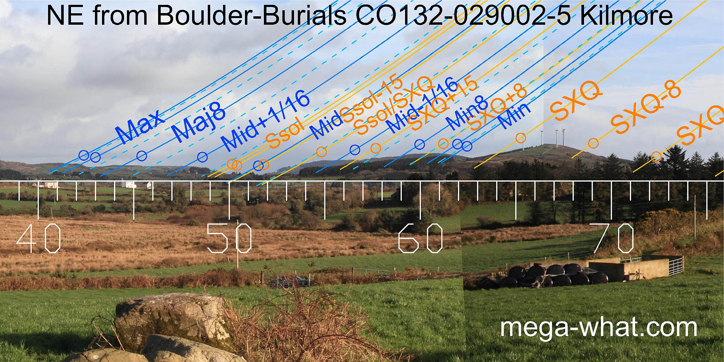 The four boulders are set in a line. Their arrangement is unusual but significant.
In this direction, the axis of the line of boulders indicates the general direction of the lunar sixteenth between the midpoint and the major eighth.
Apart from that, interpretation of the horizon is exactly as from the Stone Row.
From both sites, the minor standstillLunistice positions vary cyclically over an 18.6 year period but are fairly static for more than a year at either end of the range
occurs on the hilltop on the valley's south side and the summer cross-quarter falls on the north slope of the next hill.
The four boulders are set in a line. Their arrangement is unusual but significant.
In this direction, the axis of the line of boulders indicates the general direction of the lunar sixteenth between the midpoint and the major eighth.
Apart from that, interpretation of the horizon is exactly as from the Stone Row.
From both sites, the minor standstillLunistice positions vary cyclically over an 18.6 year period but are fairly static for more than a year at either end of the range
occurs on the hilltop on the valley's south side and the summer cross-quarter falls on the north slope of the next hill.
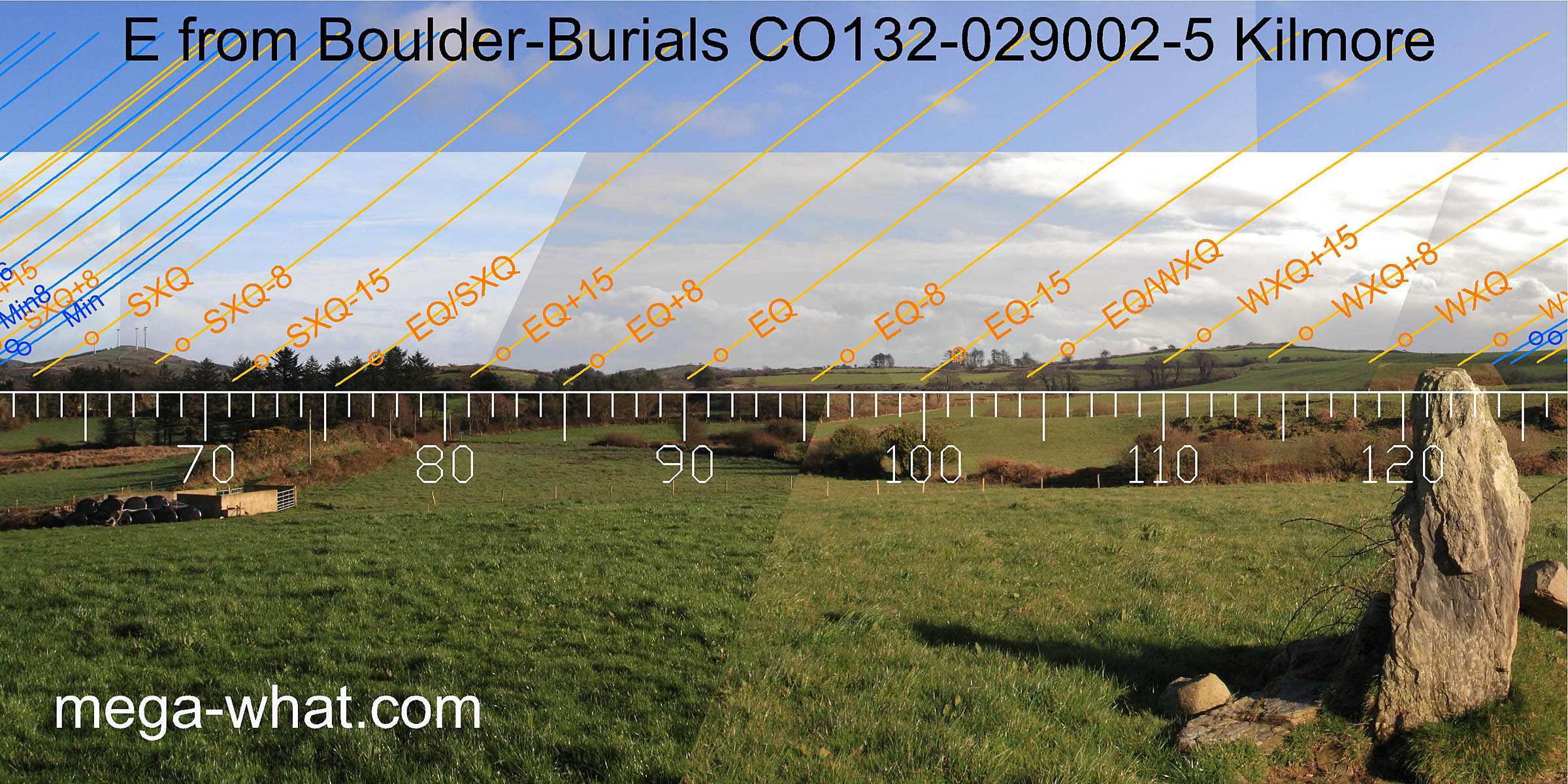 The equinox and the half-month north of it both fall on hilltops.
Further south, the half and quarter-months north of the winter cross-quarter are on two highpoints of the same hill with the cross-quarter itself at its southern basal break.
The equinox and the half-month north of it both fall on hilltops.
Further south, the half and quarter-months north of the winter cross-quarter are on two highpoints of the same hill with the cross-quarter itself at its southern basal break.
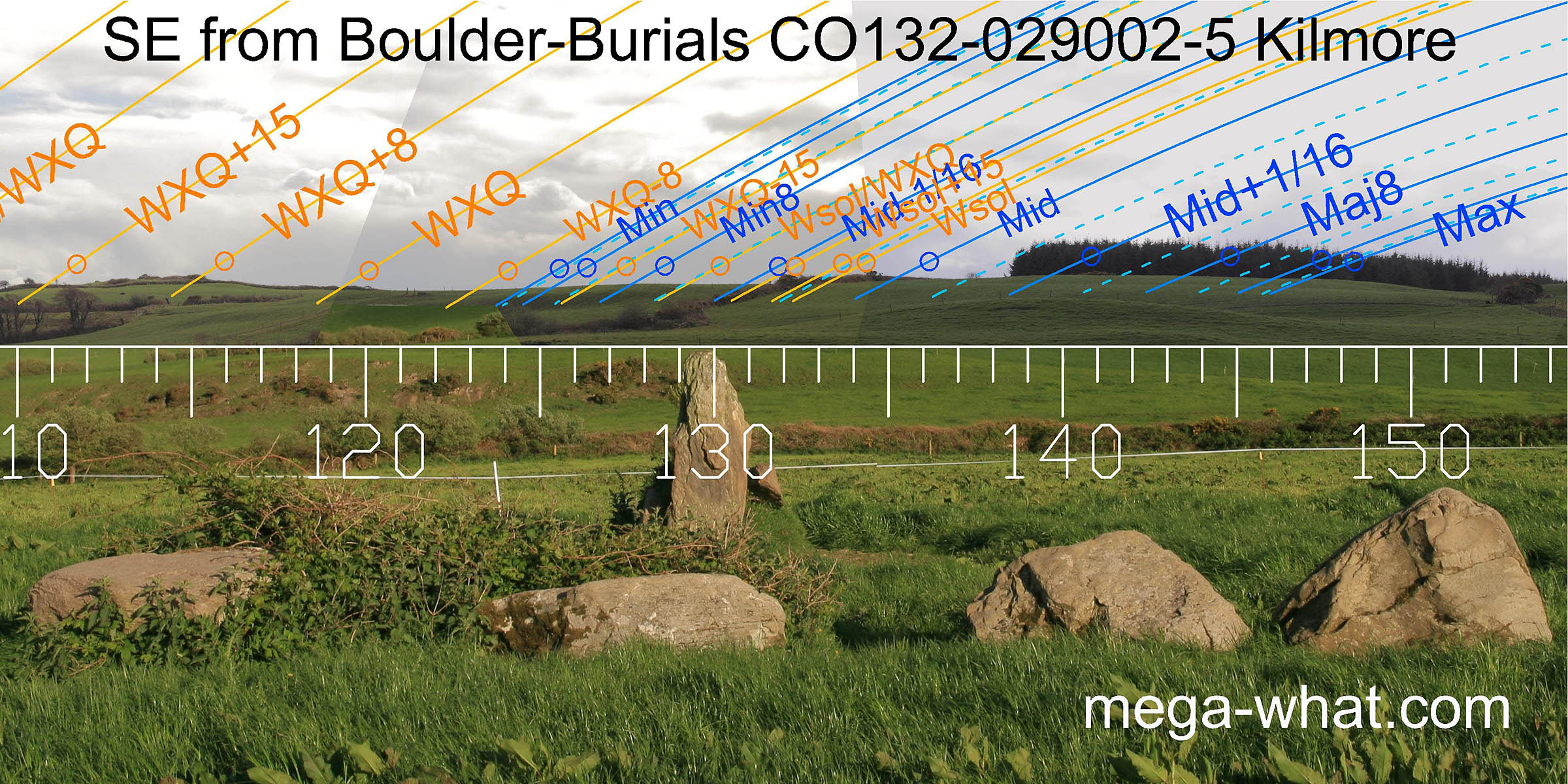 The far south-east is rolling reclaimed pasture but the main correspondances are still discernible. the lunar minor eighth is on a high point.
The position of the winter solstice is masked by a field boundary but there is a clear break in the horizon profile in that area.
The three main points of the major half of the lunisticeLunistices are the most northerly and southerly moons of the month. The lunar equivalent of solstices - more.
range also occur at breakpoints.
This is the nearest horizon and exact declination values are sensitive to observing position. The row of boulders effectively delimits this critical zone.
The far south-east is rolling reclaimed pasture but the main correspondances are still discernible. the lunar minor eighth is on a high point.
The position of the winter solstice is masked by a field boundary but there is a clear break in the horizon profile in that area.
The three main points of the major half of the lunisticeLunistices are the most northerly and southerly moons of the month. The lunar equivalent of solstices - more.
range also occur at breakpoints.
This is the nearest horizon and exact declination values are sensitive to observing position. The row of boulders effectively delimits this critical zone.
 Views south-west and west from the site are now obscured by a field boundary and it looks like the lunisticeLunistices are the most northerly and southerly moons of the month. The lunar equivalent of solstices - more.
range runs up the south-facing slope with the
winter cross-quarters somewhere close to the hilltop. A section of distant ridge may also be hidden.
Views south-west and west from the site are now obscured by a field boundary and it looks like the lunisticeLunistices are the most northerly and southerly moons of the month. The lunar equivalent of solstices - more.
range runs up the south-facing slope with the
winter cross-quarters somewhere close to the hilltop. A section of distant ridge may also be hidden.
To the right of the spruce trees and behind the hedge, 95m away to the west-south-west, is Standing Stone Pair CO132-029001.
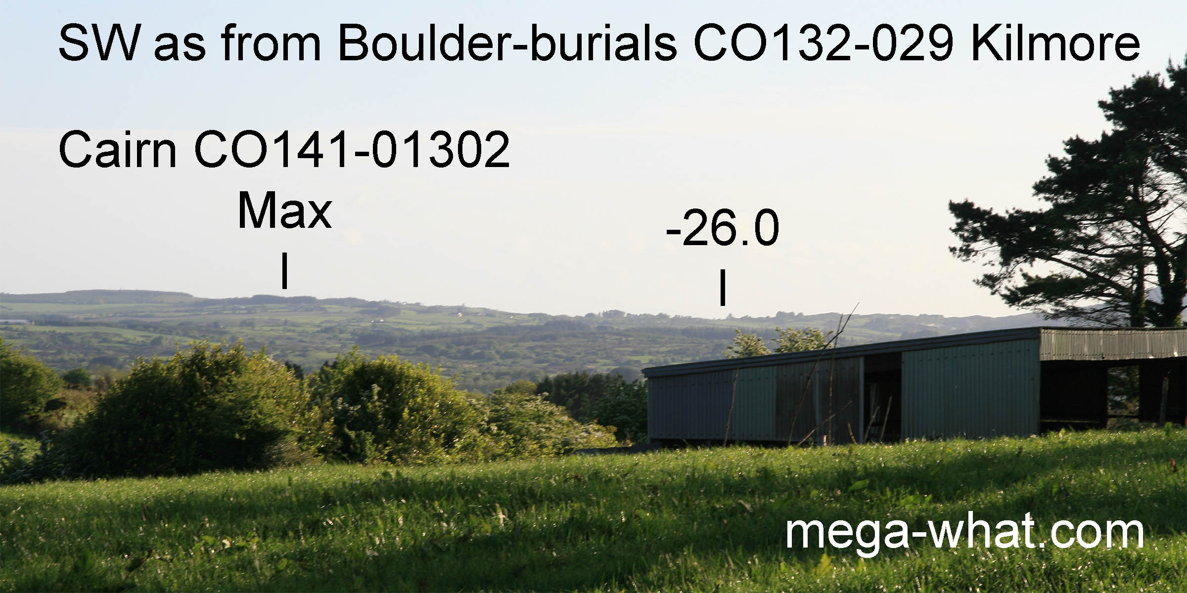 Were it not for the bank, Cairn CO141-01302 would just about be visible.
It might be necessary to walk towards the hilltop a bit or stand on top of one of the boulders but the cairn would have marked the most extreme southerly moonset position.
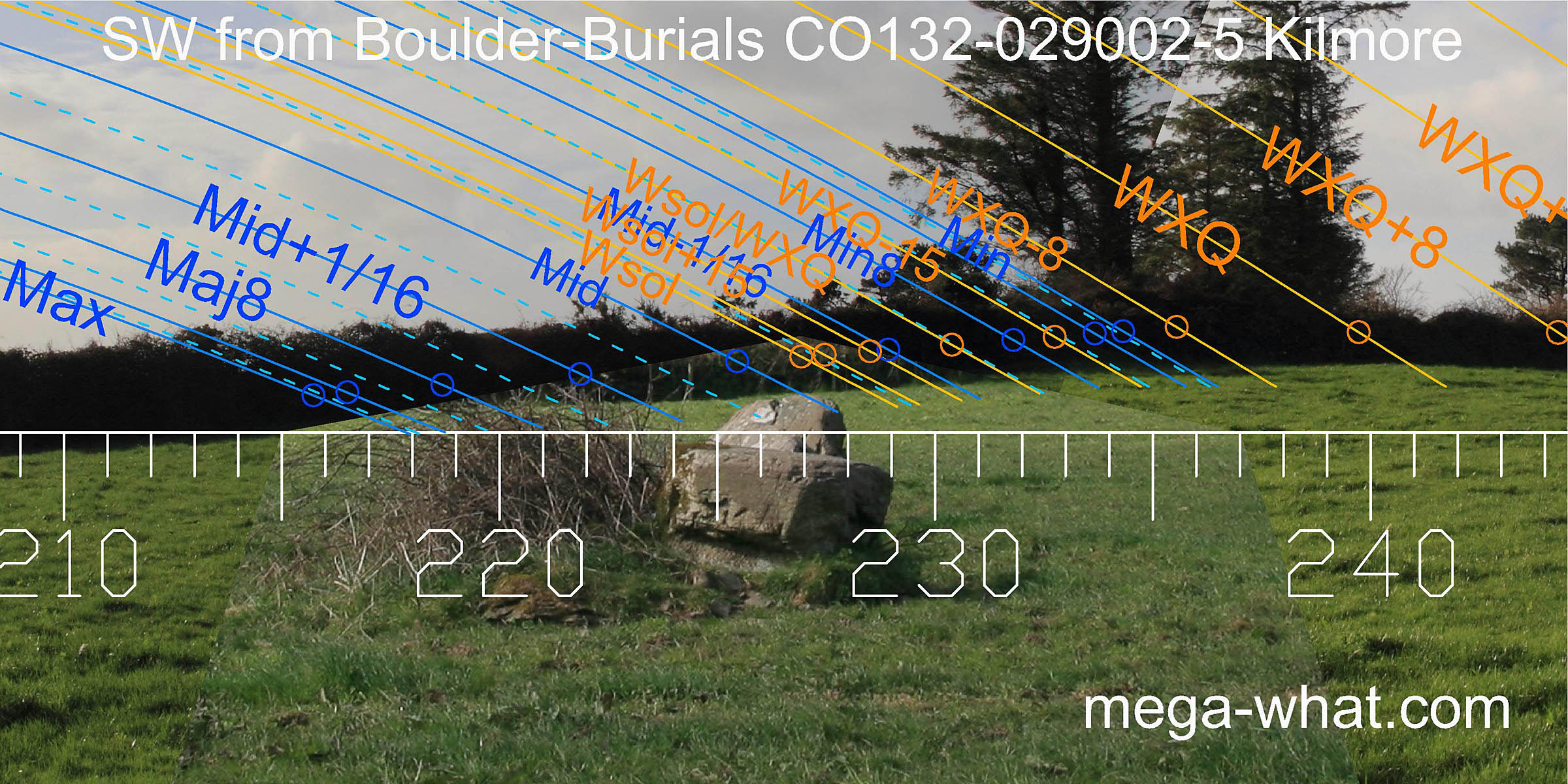
The axis of the line of boulders indicates azimuth 227° and the lunar midpoint in a dip.
Were it not for the bank, Cairn CO141-01302 would just about be visible.
It might be necessary to walk towards the hilltop a bit or stand on top of one of the boulders but the cairn would have marked the most extreme southerly moonset position.
The axis of the line of boulders indicates azimuth 227° and the lunar midpoint in a dip.
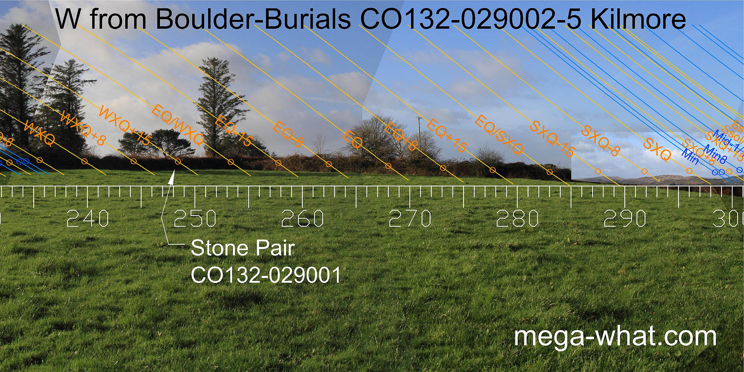 The western view is now of a field boundary but should be the local hilltop with Standing Stone Pair CO132-029001 on the skyline.
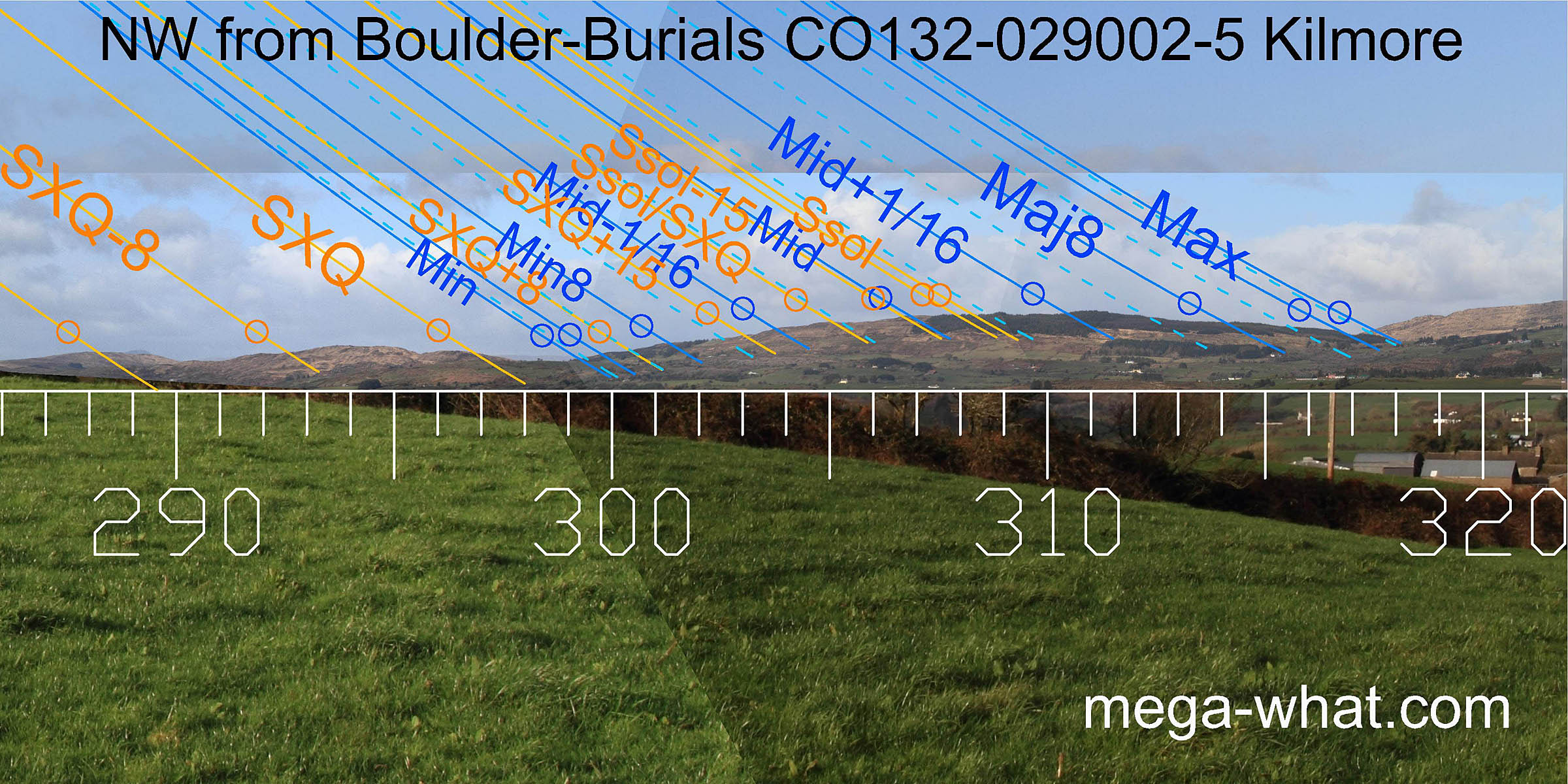 To the north-west is Glanatnaw Hill with the summer solstice on its top and the lunar limits at its base on either side.
- Kilmore Standing Stone Pair is 90m south-west (242°)
- Baurnahulla Boulder-Burial is 1.7km north-east (35°)
- Cullomane Boulder-Burial is 9.5km west (280°)
- Leitry Stone Row is 6.2km north (9°)
References
- Archaeological Survey of Ireland, record details. www.archaeology.ie/archaeological-survey-ireland
- POWER, D. et al. 1992 Archaeological Inventory of County Cork, Volume 1: West Cork. Dublin: Stationary Office. p59, no 410.
- RONAN, S. et al. 2009 Archaeological Inventory of County Cork, Volume 5. Dublin: Stationary Office. pp14-15, nos. 15338, 15339, 15340, 15341.