
 The taller south-west stone is leaning heavily to the north-east and is propped up by a boulder.
Both stones are sufficiently wide to indicate directions independently and their axes are noticeably different with the shorter one turned out from the pair axis.
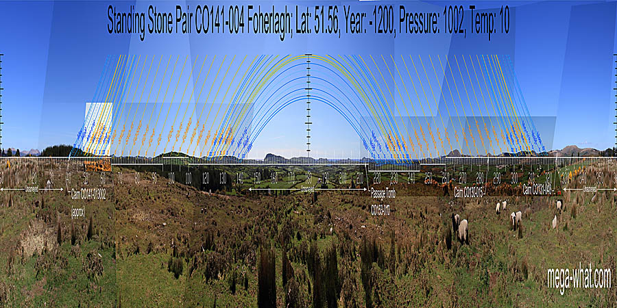
The pair axis is around 72/252°, the north-east stone axis is about 49/229° [Axial Pics].
The taller south-west stone is leaning heavily to the north-east and is propped up by a boulder.
Both stones are sufficiently wide to indicate directions independently and their axes are noticeably different with the shorter one turned out from the pair axis.
The pair axis is around 72/252°, the north-east stone axis is about 49/229° [Axial Pics].
South is in a dip. On a ridge, just left of the sea and over a bend in the Ilen estuary [Pic].
![[Pic].](Foherlagh-S.jpg)
North seems to be in a dip in a run of distant hills [Pic] over the end of the local ridge.
![[Pic]](Foherlagh-N.jpg)
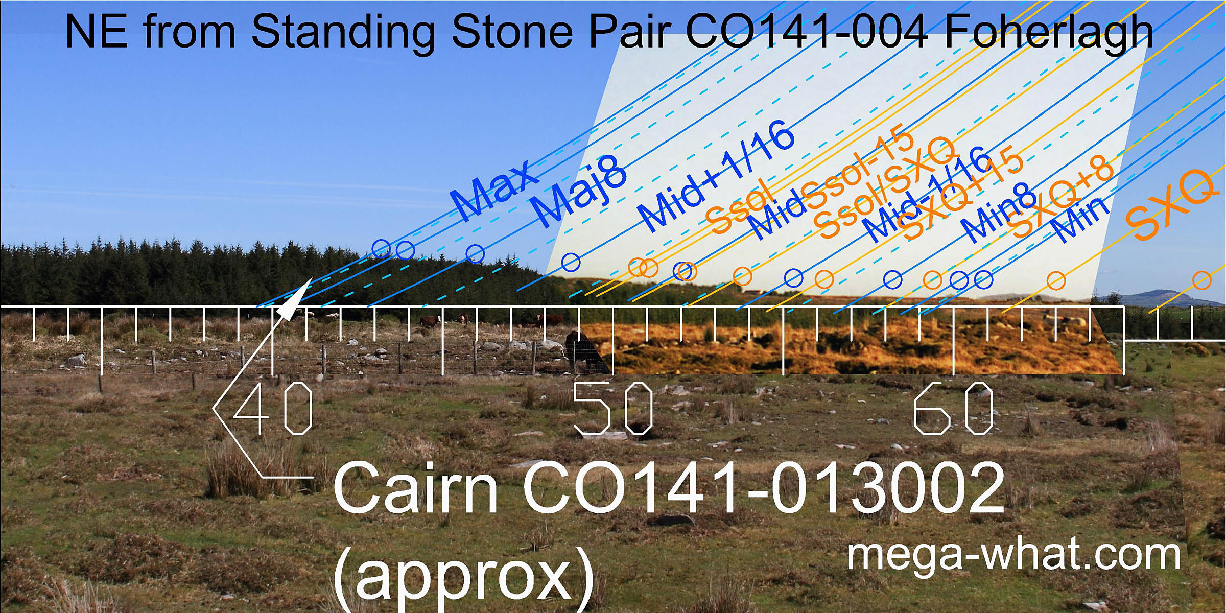 Skeagh Cairn, concealed by the forest would mark the most extreme northerly moonrise position,
while the axis of the north-east stone indicates summer solstice sunrise at a scrub covered low hump.
South of there, the north base of the first distant hill is a sixteenth from the minor standstillLunistice positions vary cyclically over an 18.6 year period but are fairly static for more than a year at either end of the range
and its south base is the standstillLunistice positions vary cyclically over an 18.6 year period but are fairly static for more than a year at either end of the range.
Skeagh Cairn, concealed by the forest would mark the most extreme northerly moonrise position,
while the axis of the north-east stone indicates summer solstice sunrise at a scrub covered low hump.
South of there, the north base of the first distant hill is a sixteenth from the minor standstillLunistice positions vary cyclically over an 18.6 year period but are fairly static for more than a year at either end of the range
and its south base is the standstillLunistice positions vary cyclically over an 18.6 year period but are fairly static for more than a year at either end of the range.
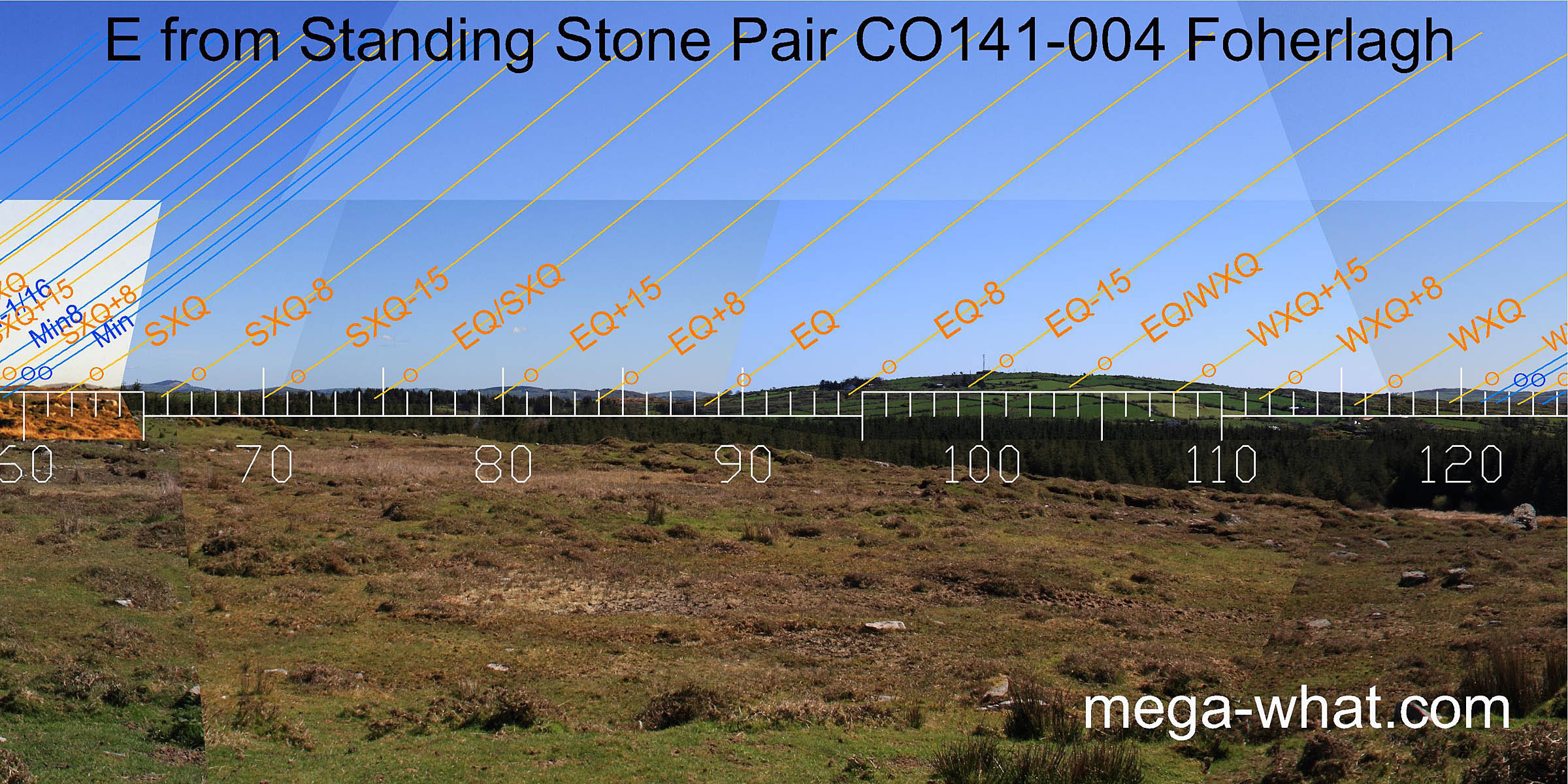 The second distant hilltop marks the summer cross-quarters.
South of that, a nicely undulating distant horizon provides markers all the way to the equinox, which is at the intersect of the far horizon with the northern side of the local hill of Knockonna.
The second distant hilltop marks the summer cross-quarters.
South of that, a nicely undulating distant horizon provides markers all the way to the equinox, which is at the intersect of the far horizon with the northern side of the local hill of Knockonna.
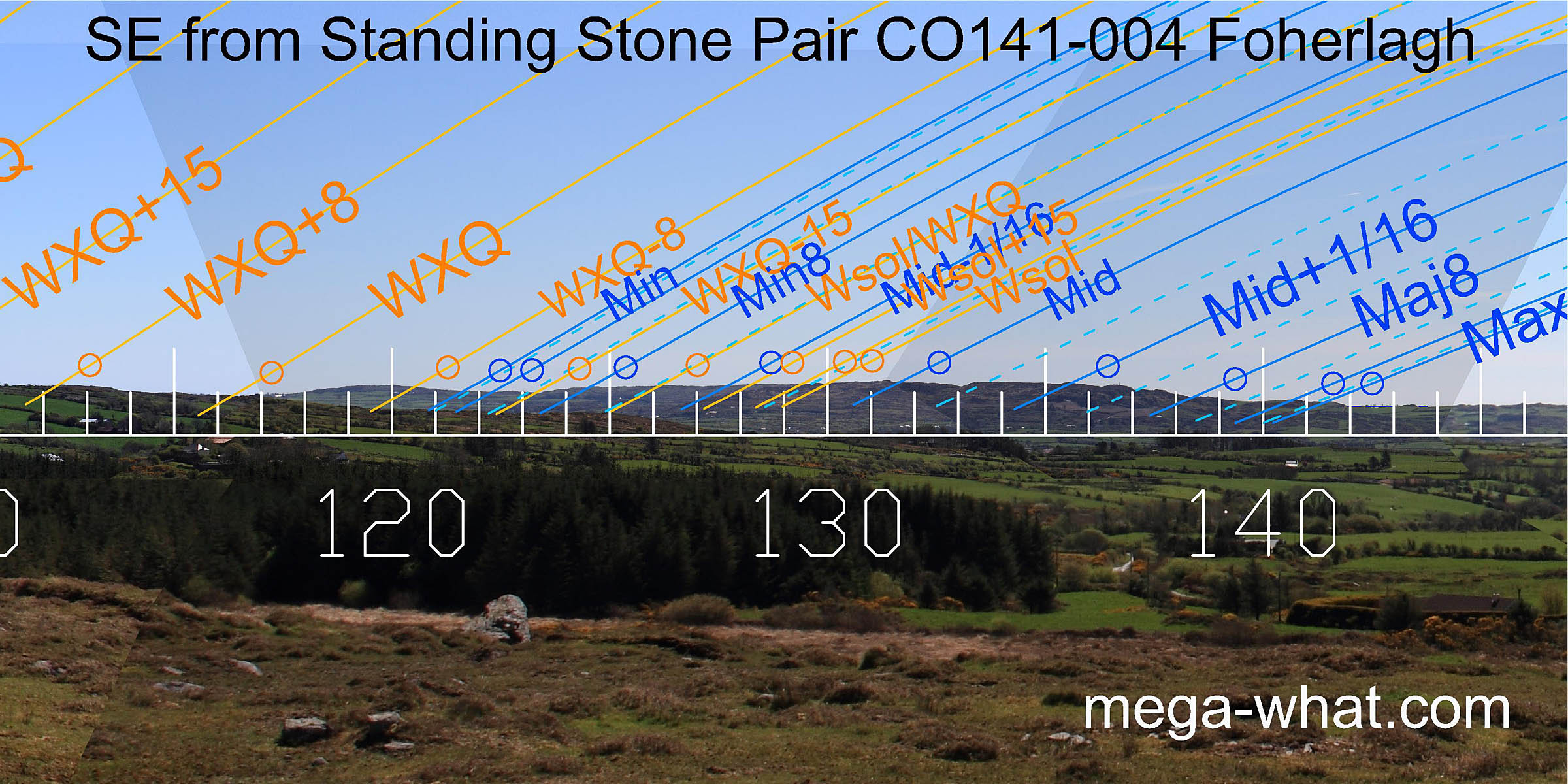 The curving slopes of Knockonna lead on to a more distant south-east horizon and the intersect marks the winter cross-quarters.
The first dip in this distant ridge of Lick hill is the minor standstillLunistice positions vary cyclically over an 18.6 year period but are fairly static for more than a year at either end of the range
and the highest point is lunar mid-cycle.
Beyond the south end of the hill is a fairly flat section and the first step here marks the major end of the lunisticeLunistices are the most northerly and southerly moons of the month. The lunar equivalent of solstices - more.
range.
The curving slopes of Knockonna lead on to a more distant south-east horizon and the intersect marks the winter cross-quarters.
The first dip in this distant ridge of Lick hill is the minor standstillLunistice positions vary cyclically over an 18.6 year period but are fairly static for more than a year at either end of the range
and the highest point is lunar mid-cycle.
Beyond the south end of the hill is a fairly flat section and the first step here marks the major end of the lunisticeLunistices are the most northerly and southerly moons of the month. The lunar equivalent of solstices - more.
range.
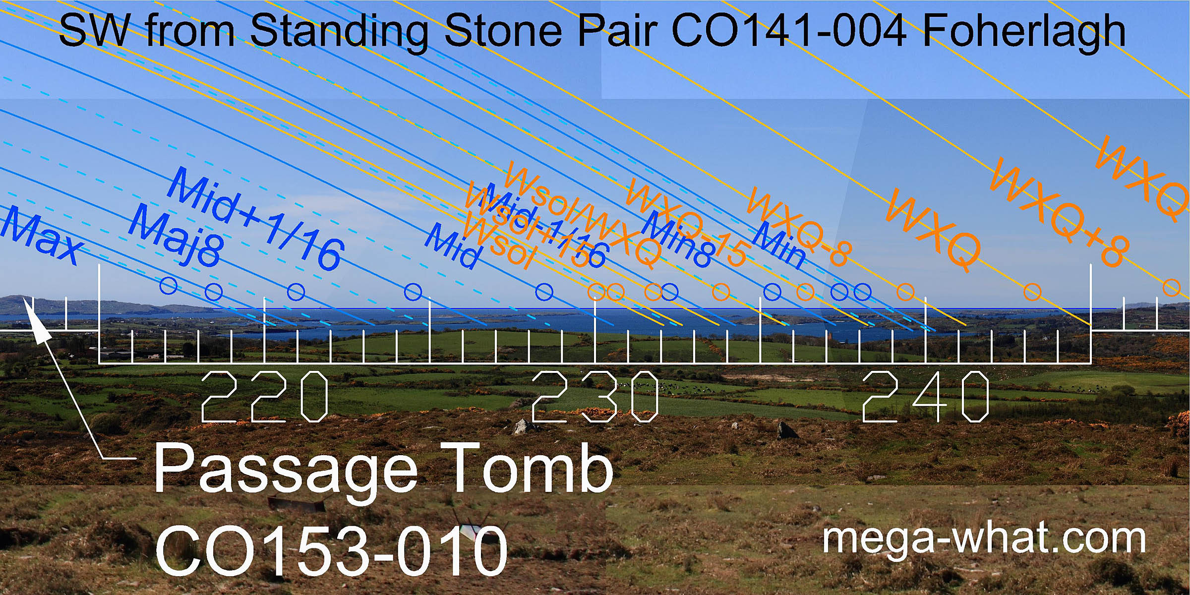 To the south-west is Roaringwater Bay with the north-east stone's axis indicating the direction of lunar mid-cycle on the sea horizon.
The west intersect of Clear Island with the sea is the major standstillLunistice positions vary cyclically over an 18.6 year period but are fairly static for more than a year at either end of the range.
Fastnet rock is the major eighth. Long Island, towards the west of the bay, has the cross-quarters at its west end.
A smaller island to its east has the lunar minor eighth and the half-month south of the cross-quarters at its east end.
To the south-west is Roaringwater Bay with the north-east stone's axis indicating the direction of lunar mid-cycle on the sea horizon.
The west intersect of Clear Island with the sea is the major standstillLunistice positions vary cyclically over an 18.6 year period but are fairly static for more than a year at either end of the range.
Fastnet rock is the major eighth. Long Island, towards the west of the bay, has the cross-quarters at its west end.
A smaller island to its east has the lunar minor eighth and the half-month south of the cross-quarters at its east end.
 The western horizon, while not dramatic, is quite useful. The pair axis gives -11.6° over it, which is a half-month the equinoctial side of the winter cross-quarters.
The south top of Mt Gabriel is a quarter-month off the equinox which itself falls on another hill at Gabriel's north base.
The western horizon, while not dramatic, is quite useful. The pair axis gives -11.6° over it, which is a half-month the equinoctial side of the winter cross-quarters.
The south top of Mt Gabriel is a quarter-month off the equinox which itself falls on another hill at Gabriel's north base.
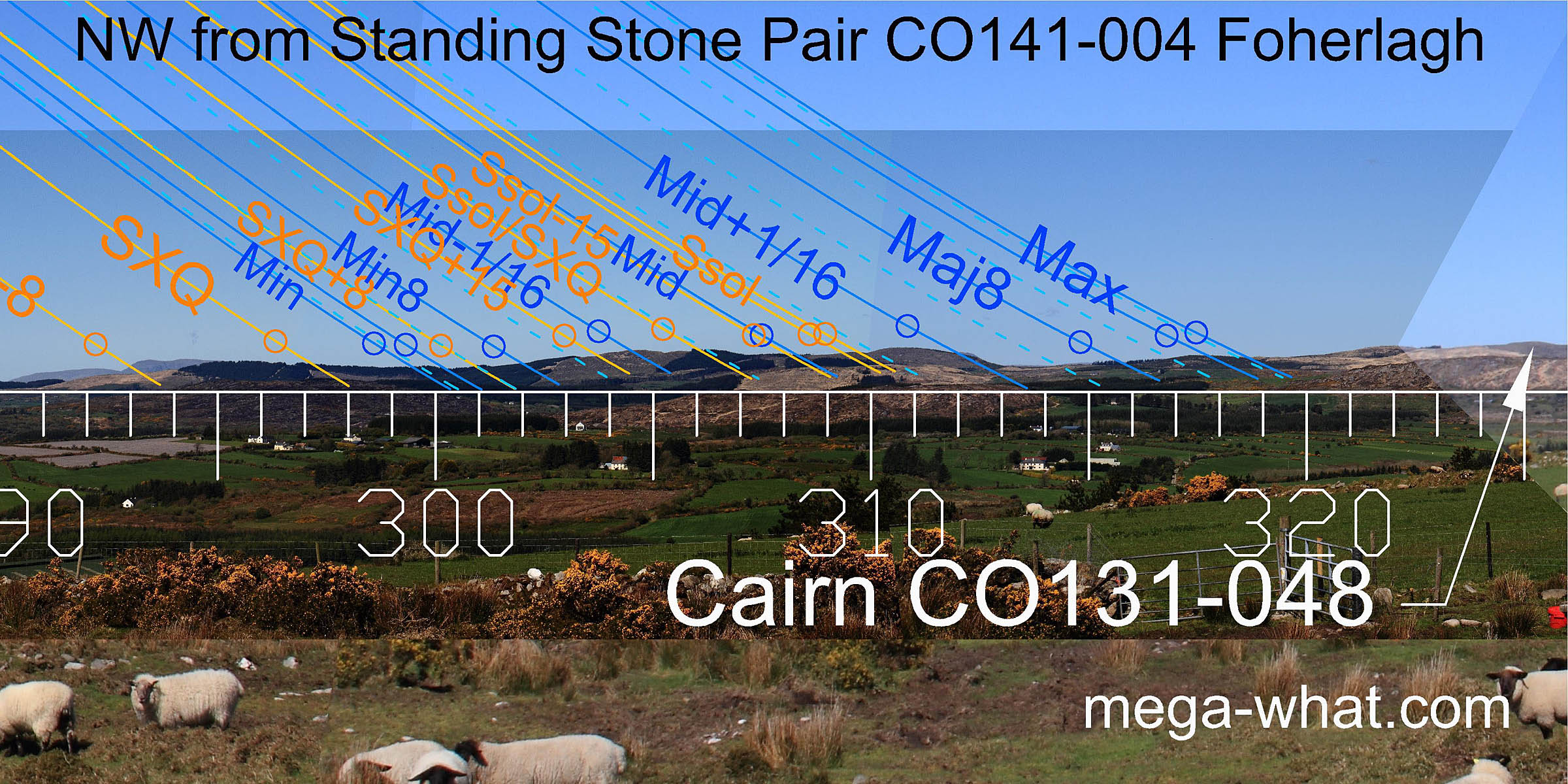 North-west, an undulating but now forested ridge gives a fourth lunisticeLunistices are the most northerly and southerly moons of the month. The lunar equivalent of solstices - more.
range.
Letterlicky Cairn is on the horizon but does not occupy a significant position when viewed from here.
North-west, an undulating but now forested ridge gives a fourth lunisticeLunistices are the most northerly and southerly moons of the month. The lunar equivalent of solstices - more.
range.
Letterlicky Cairn is on the horizon but does not occupy a significant position when viewed from here.
This Standing Stone pair is visible on the north-west horizon from Lisheen Boulder-Burial 4.7km away but the relationship is not significant.
It is also intervisible with Cappagh More Stone Pair 4.1km to the north-west but neither site is on the horizon from the other.
References
- Archaeological Survey of Ireland, record details. www.archaeology.ie/archaeological-survey-ireland
- Ó'NUALLÁIN, SEÁN 1988 Stone Rows in the South of Ireland. Proceedings of the Royal Irish Academy 88c:179-256, p248, no.142.
- POWER, D. et al. 1992 Archaeological Inventory of County Cork, Volume 1: West Cork. Dublin: Stationary Office. p41, no.186.