
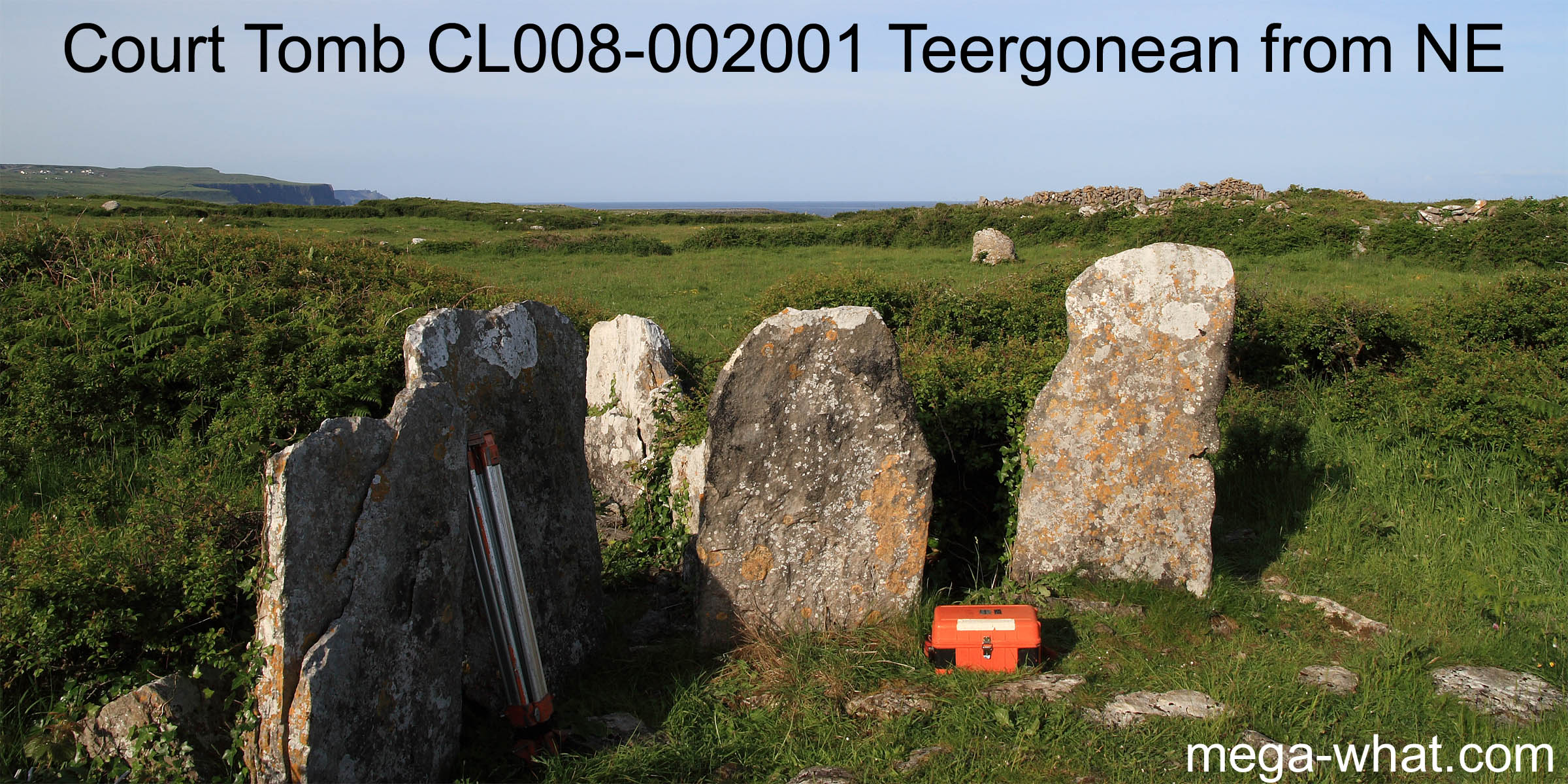
 Teergonean Court Tomb is on the west coast of the Burren, Co. Clare.
About 2km north-west of Doolin and not far from the end of a cul-de-sac where the turning space is unsuitable for large vehicles.
 South is at a step in a hilltop [Pic]. This hill defines the view, having
lunar standstillsLunistice positions vary cyclically over an 18.6 year period but are fairly static for more than a year at either end of the range
to both sides and height to the left, lowness to the right.
South is at a step in a hilltop [Pic]. This hill defines the view, having
lunar standstillsLunistice positions vary cyclically over an 18.6 year period but are fairly static for more than a year at either end of the range
to both sides and height to the left, lowness to the right.
![[Pic].](TeergoneanCourt-S.jpg)
North is close to the intersect of local ground and distant horizons [Pic].
![[Pic].](TeergoneanCourt-N.jpg)
This karst landscape has since been much interfered with in the later prehistoric period and beyond...
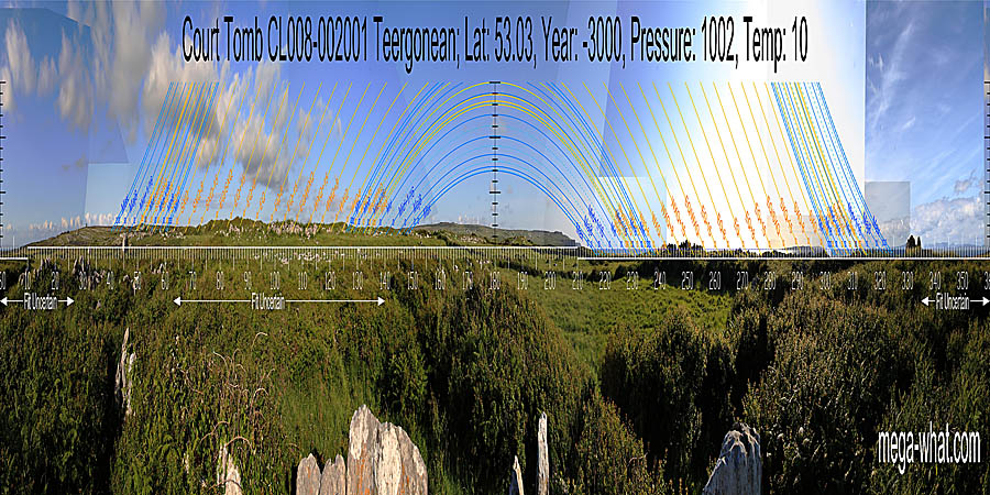
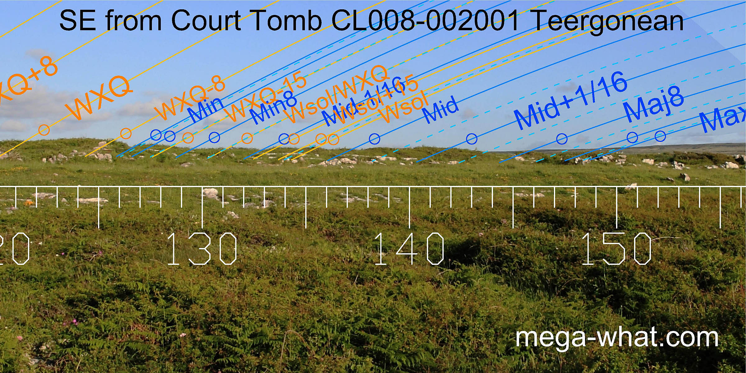
The north-eastern horizon is neither particularly distant nor rugged. The tomb axis is beyond lunar standstillLunistice positions vary cyclically over an 18.6 year period but are fairly static for more than a year at either end of the range in this direction [Pic], suggesting a true orientation to the south-west.
![[Pic]](TeergoneanCourt-NEax.jpg)
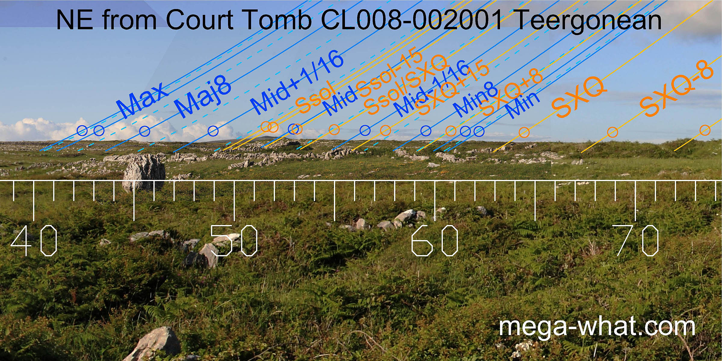
The major eighth is at a noticeable but small hump, near the end of a wall and directly above a nearby erratic boulder when viewed from the chamber's entrance. Between this and the axial boulder is a pile of stones, possibly the remains of a cairn, about a degree beyond the lunar limit. A more distant hill has clearly been taken advantage of, with its top as well as both basal intersects providing significant markers.
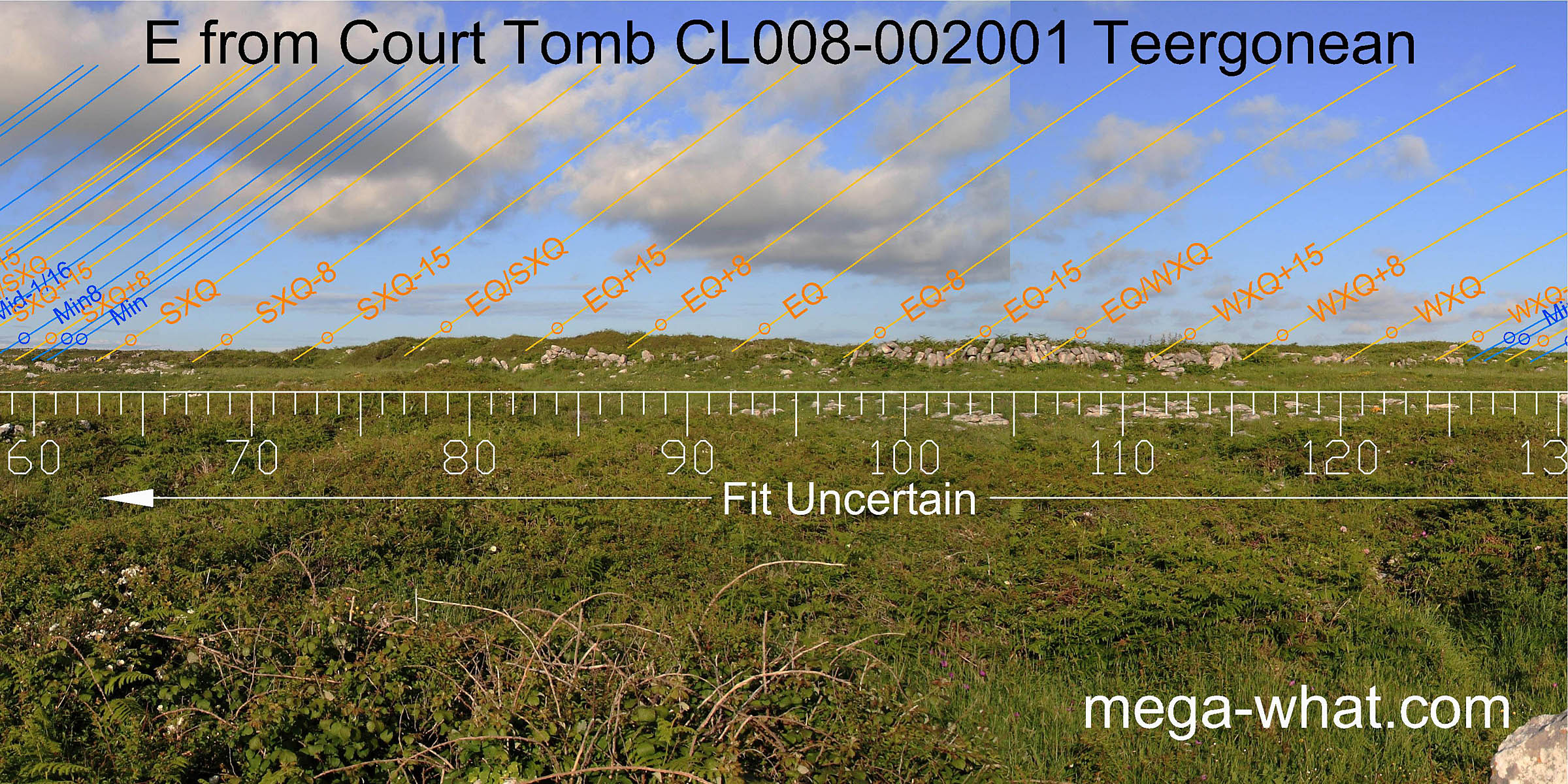 The eastern horizon is very close and was not surveyed as walls and low windswept bushes contribute significantly to the existing profile.
 The intersect of this local eastern horizon with a much more distant ridge marks the inner boundary of the period centred on the lunar major eighth.
The ridge then rises slightly and falls to a shallow dip which marks the outer boundary of the period centred on the major eighth.
The top of the first step on the ridge is just beyond the lunar limit. A slight notch in the ridge is almost due south.
The intersect of this local eastern horizon with a much more distant ridge marks the inner boundary of the period centred on the lunar major eighth.
The ridge then rises slightly and falls to a shallow dip which marks the outer boundary of the period centred on the major eighth.
The top of the first step on the ridge is just beyond the lunar limit. A slight notch in the ridge is almost due south.
There is a sort of symmetry with the further reaches of the lunisticeLunistices are the most northerly and southerly moons of the month. The lunar equivalent of solstices - more. range "off the ends" as it were, to both north-east and south-east.
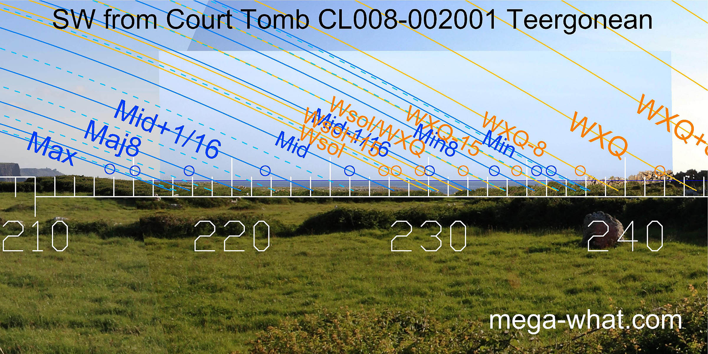 The tomb's south-western axis is just beyond the lunar limit which is marked by the intersect between land and sea horizons [Pic].
Two steps in the landscape below the sea horizon then provide markers for the major eighth and winter solstice.
Close to the tomb is another "erratic" block, perhaps deliberately placed? Its top marks the quarter-month south of winter solstice while its south edge is accurate for the minor lunar limit.
The tomb's south-western axis is just beyond the lunar limit which is marked by the intersect between land and sea horizons [Pic].
Two steps in the landscape below the sea horizon then provide markers for the major eighth and winter solstice.
Close to the tomb is another "erratic" block, perhaps deliberately placed? Its top marks the quarter-month south of winter solstice while its south edge is accurate for the minor lunar limit.
![[Pic].](TeergoneanCourt-SWax.jpg)
Just south of this are more "erratics" on the limestone pavement, currently hidden behind low bushes. One provides a better mark for the solstice, the other two are accurate markers for a lunar sixteenth and the solstice / cross-quarter midpoint. Chance or design?
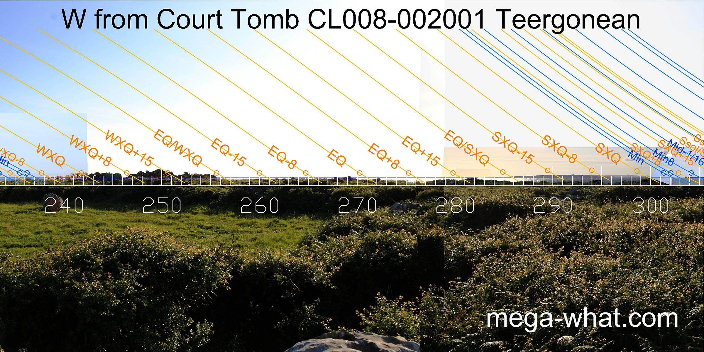 Due west, the very local limestone pavement is close to the sea horizon and, where walls now interfere, other markers may once have been easily placed.
The Arran Islands provide a range of markers from a half-month north of the equinox to a quarter-month north of the cross-quarter. This last is also an effective marker for the lunar sixteenth adjacent to the minor standstillLunistice positions vary cyclically over an 18.6 year period but are fairly static for more than a year at either end of the range and begins a short segment of sea horizon.
 After the short sea gap, the southern end of the profile of Connemara marks the lunar midpoint and the half-month bracket for the summer solstice.
The south and north limits of some more distant and higher hills provide markers for the sixteenth and major eighth, then the lunar limit is at the first hilltop on a rising ridge.
After the short sea gap, the southern end of the profile of Connemara marks the lunar midpoint and the half-month bracket for the summer solstice.
The south and north limits of some more distant and higher hills provide markers for the sixteenth and major eighth, then the lunar limit is at the first hilltop on a rising ridge.
All the interruptions to these westerly views are formed by walls and low bushes. The original view would have been bare limestone pavement just below the horizon. Quite possibly this had other markers placed on it. Note that the ground to both east and west is very close and thus interaction of profile and sky is very susceptible to exact observer position in those directions.
- Possible use of an "erratic" boulder as a sub-horizon marker may also be seen at Poulnabrone Portal Tomb, c.17km east-north-east
- Similar use of coastal position and sea/land relations by a Court Tomb may be seen at Ballynamona Court Tomb in Waterford.
- Locally, related but later Bronze Age magico-religeous activity may be seen at Stoolery Hill Barrow, above Doolin village.
References
- Archaeological Survey of Ireland, record details. www.archaeology.ie/archaeological-survey-ireland