
 Ballynamona Court Tomb is to the south of both Dungarvan and Helvick Head and not far from the Mine Head lighthouse.
An excavation in 1938 found a prepared floor, potsherds, some poor flints and a stone disc but no date.
Ballynamona Court Tomb is to the south of both Dungarvan and Helvick Head and not far from the Mine Head lighthouse.
An excavation in 1938 found a prepared floor, potsherds, some poor flints and a stone disc but no date.
North is just a few degrees from the intersect of far and distant horizons [Pic].
![[Pic].](Ballynamona-N.jpg)
South is a similar distance from the intersect of land and sea [Pic].
![[Pic].](Ballynamona-S.jpg)
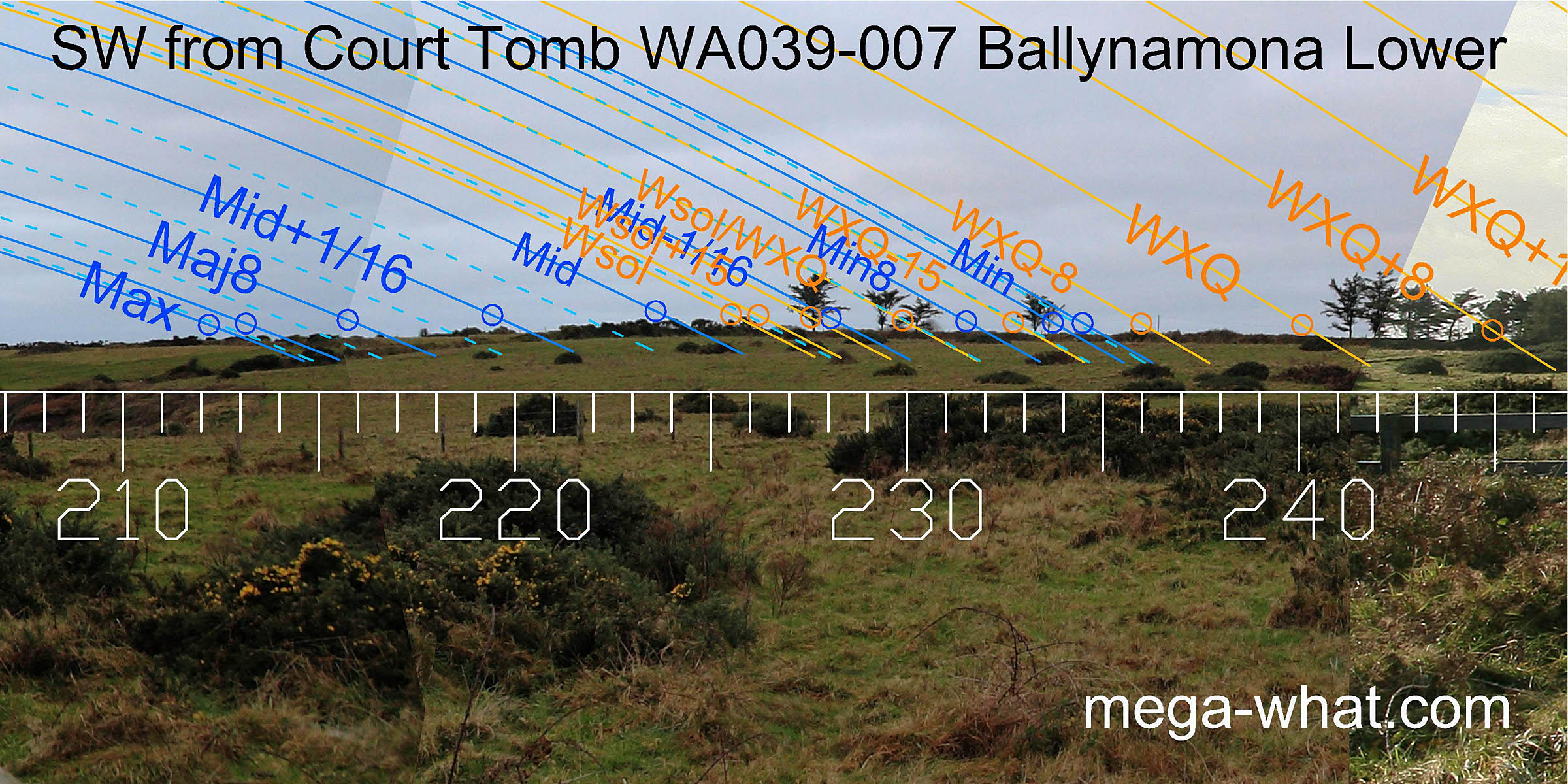
The south-western horizon is quite close and fairly featureless though considerably masked by trees, scrub and a hedge bank.
The effect is subtle but the lunisticeLunistices are the most northerly and southerly moons of the month. The lunar equivalent of solstices - more. range appears to be centred on the hilltop. Sunsets from halfway between the equinox and the cross-quarter run up the slope to the solstice, which is almost at the high point.
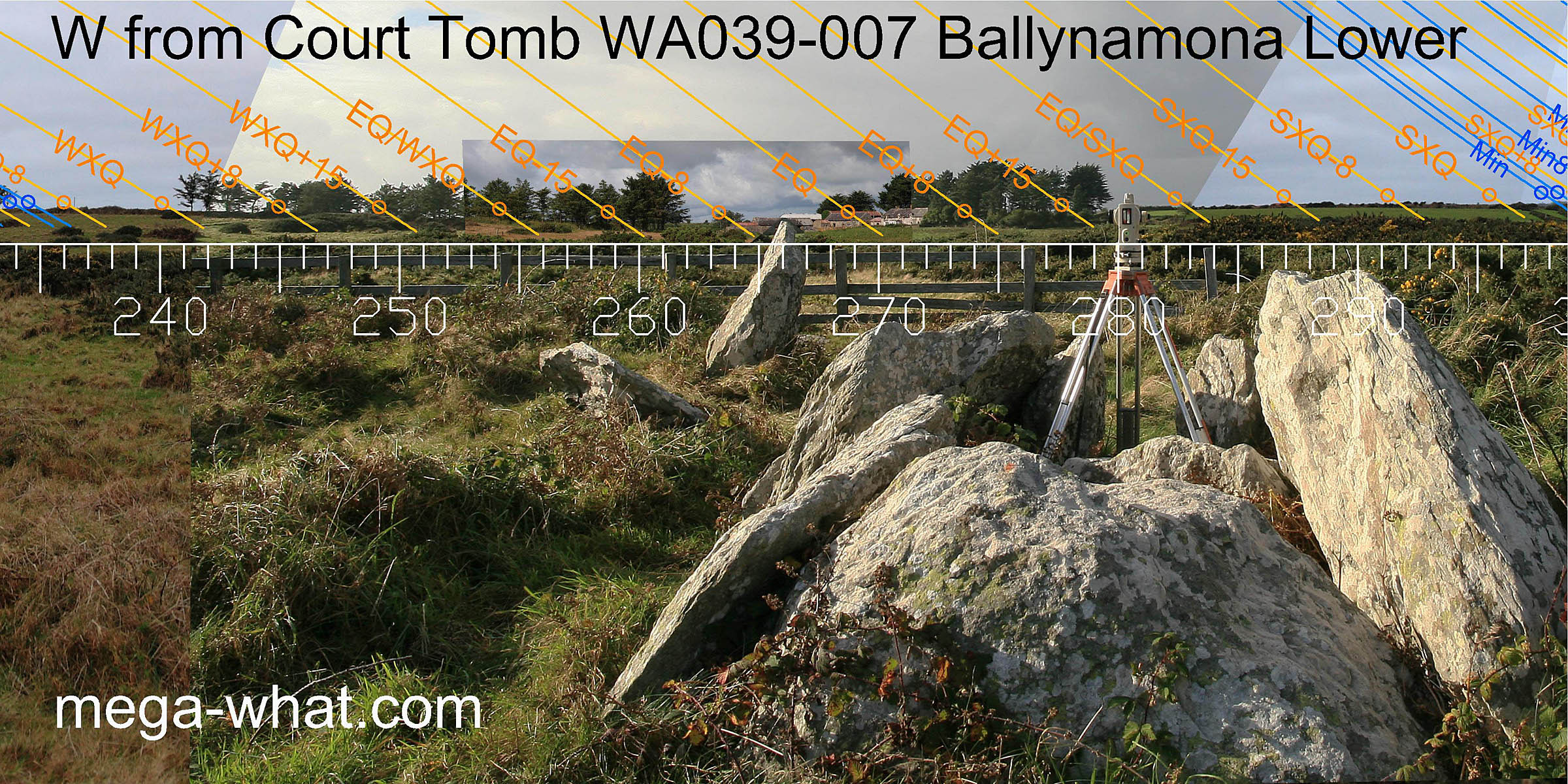 The west is also masked by trees and a farm. It looks like a fairly level distant horizon should be visible above a dip in the local ground.
This would stretch from about half-way between the winter cross-quarters and the equinox to perhaps a couple of weeks on the summer side of the equinox where, at a bit of a step, the local horizon resumes.
The west is also masked by trees and a farm. It looks like a fairly level distant horizon should be visible above a dip in the local ground.
This would stretch from about half-way between the winter cross-quarters and the equinox to perhaps a couple of weeks on the summer side of the equinox where, at a bit of a step, the local horizon resumes.
The chamber axis looks to be about half-way between the equinox and the cross-quarters, which are at the northern intersect of the local hill with more distant horizons.
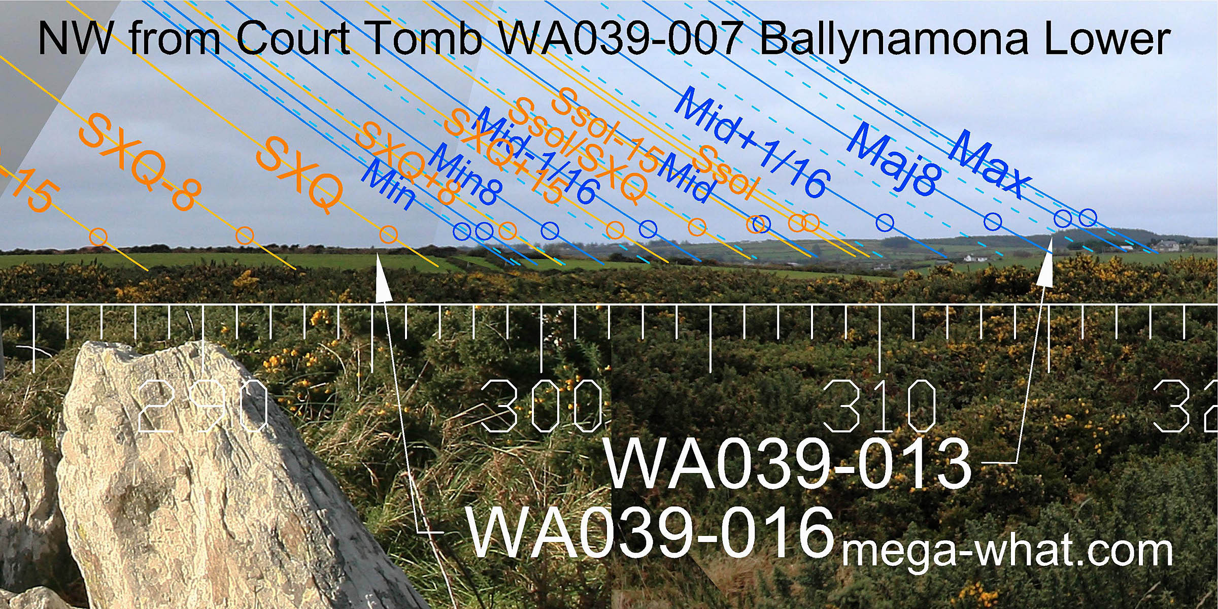 The north-west horizon rises steadily to a hilltop, the true profile of which is masked by a slightly nearer forestry plantation.
The entire lunistice range is on this distant horizon, running from just after the intersect all the way up to the hilltop.
On the hilltop is WA039-013, a large fallen Standing Stone which was possibly set there by the tomb builders as a lunar marker.
The north-west horizon rises steadily to a hilltop, the true profile of which is masked by a slightly nearer forestry plantation.
The entire lunistice range is on this distant horizon, running from just after the intersect all the way up to the hilltop.
On the hilltop is WA039-013, a large fallen Standing Stone which was possibly set there by the tomb builders as a lunar marker.
Similarly, Standing Stone WA039-016 is near the foot of the slope on much nearer ground. It is a wide thin slab facing towards the tomb and its position though unsurveyed seems lacking in astronomical utility. Intervisibility is only a possibility as the view is now obscured but the stone's approximate position may be guessed, as some tall trees near it can still be seen.
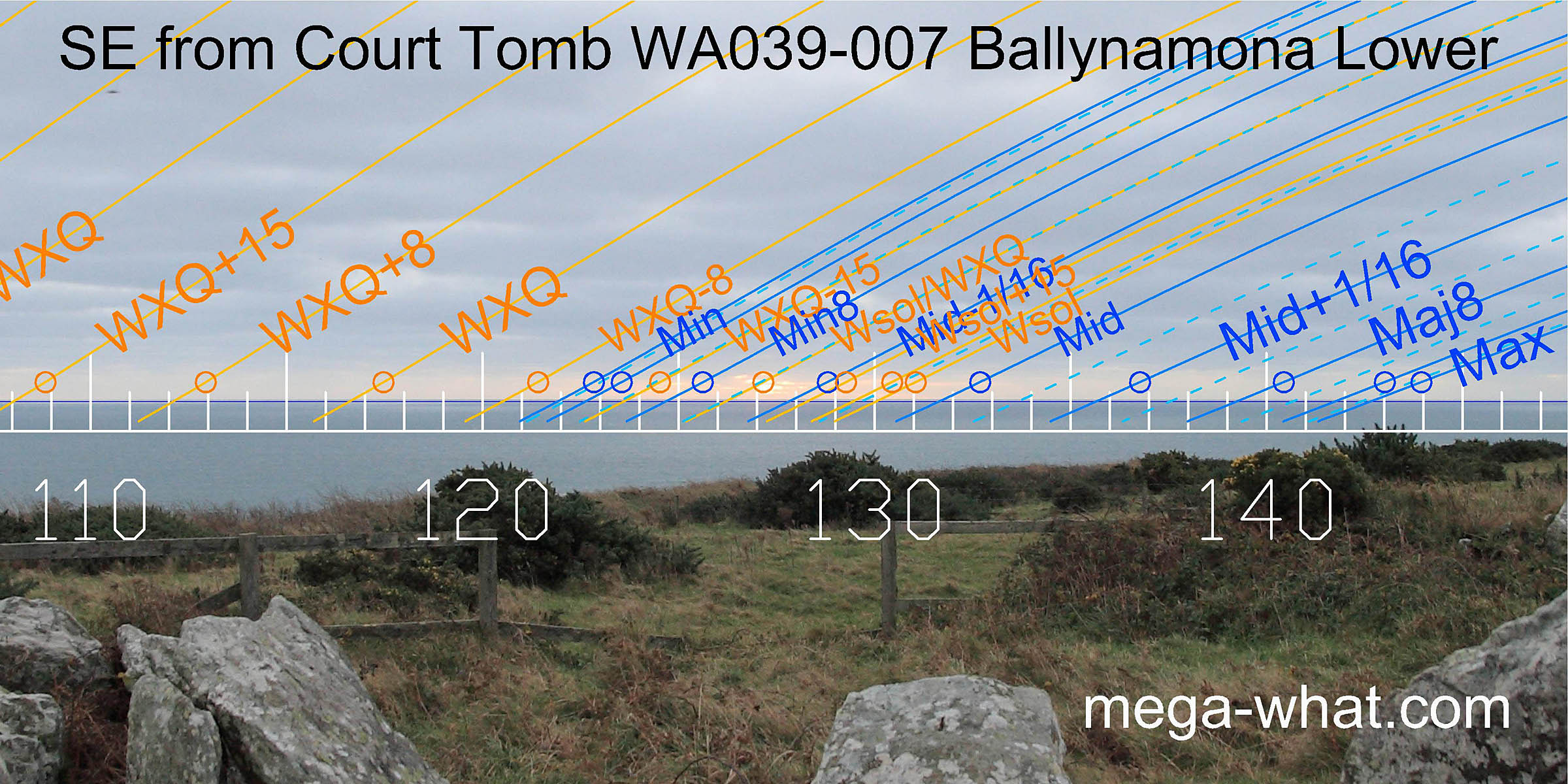 The south-east is all sea horizon. The visible coastal profile is both nearby and relatively featureless.
To the east is more sea horizon, with the equinox at the centre of the apparent dip of the coastal profile. South of the winter cross-quarters by a half-month, the sun rises from some coastal rocks, just off the mainland.
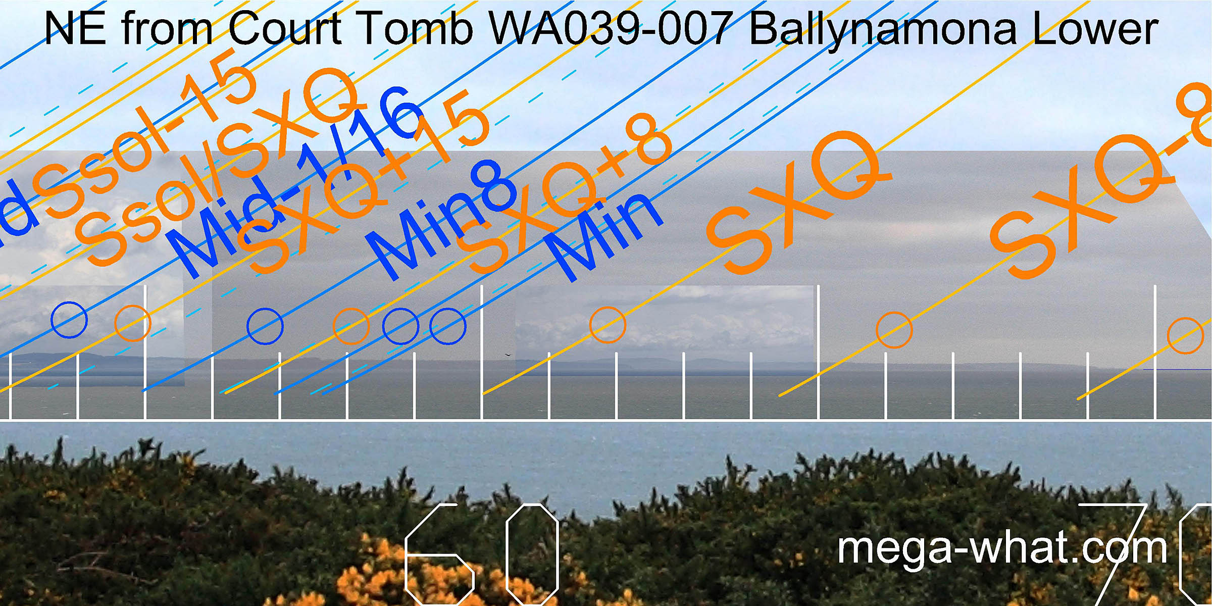 The cross-quarters are in the first major dip/notch. Then the lunistice range begins on the upslope.
Half a month north of the cross-quarter is at the second hill north of the land's end.
The north side of this hill provides a mark for a lunar sixteenth, half-way between the midpoint and the major eighth.
The cross-quarters are in the first major dip/notch. Then the lunistice range begins on the upslope.
Half a month north of the cross-quarter is at the second hill north of the land's end.
The north side of this hill provides a mark for a lunar sixteenth, half-way between the midpoint and the major eighth.
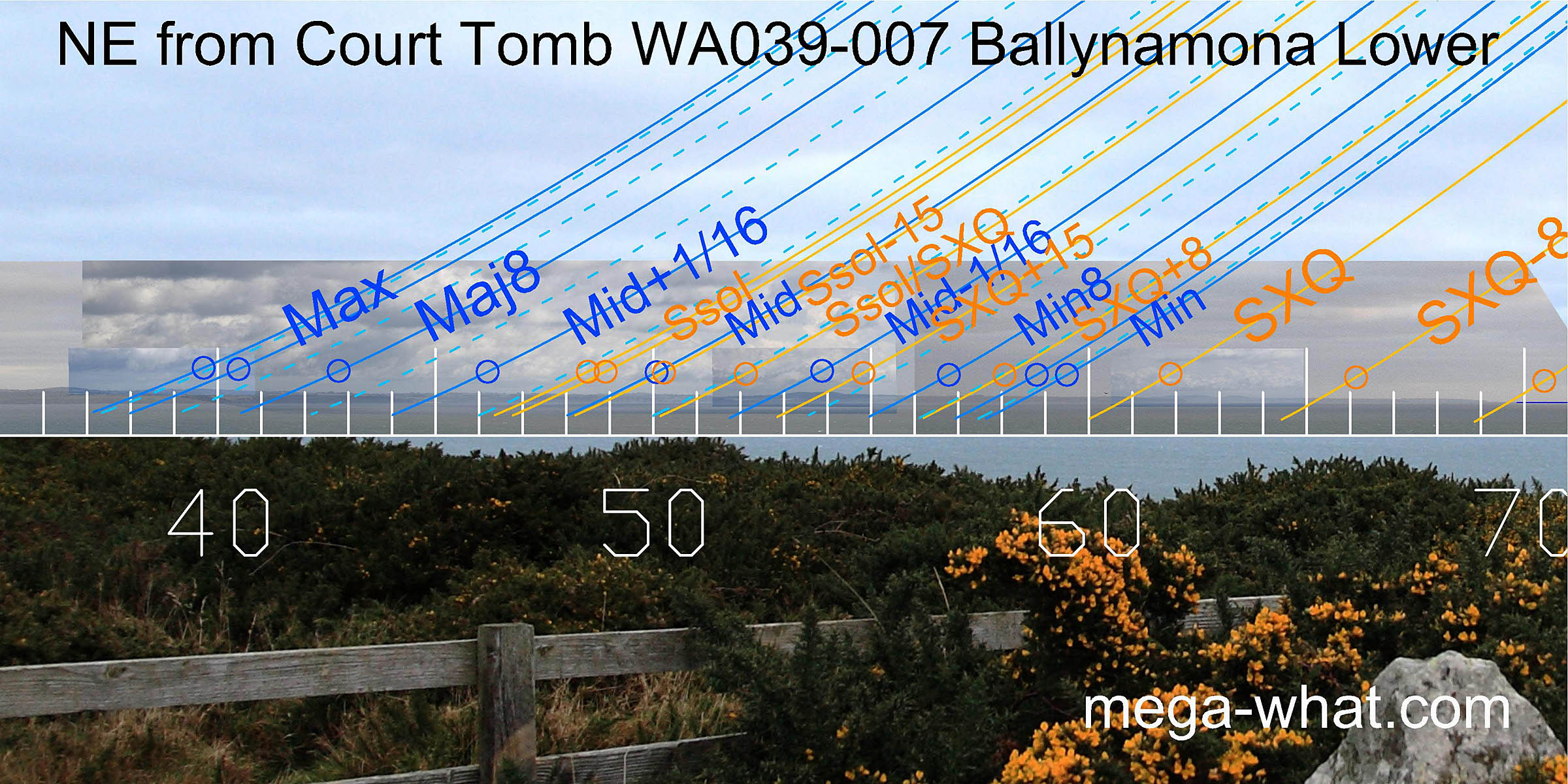 Then the half-way to/from the solstice marker is in the next dip/notch and the solstice is just after some low hills.
The major end of the lunistice cycle occurs across some higher ground with the upper limb at major standstill
first appearing at the slightly raised centre of a wide dip [Enlargement].
Then the half-way to/from the solstice marker is in the next dip/notch and the solstice is just after some low hills.
The major end of the lunistice cycle occurs across some higher ground with the upper limb at major standstill
first appearing at the slightly raised centre of a wide dip [Enlargement].
![[Enlargement].](Ballynamona-NEmax.jpg)
This monument is very close to the coast and may represent a "first attempt", making best use of limited possibilities. Use of a section of fairly local horizon has been seen elsewhere, presumably because it would be easy to control and cuts off views of more distant trees.
Not far away to the west a number of Standing Stones are recorded and it is possible that some of them could be functionally related to this tomb:
- WA039-013 Lagnagoushee mentioned above is a fairly large fallen stone and possible built lunar target.
- WA039-016 Loskeran also mentioned above, is a slab, axis about 23°, hidden behind a garden hedge. Intervisiblity is unlikely but just possible.
- WA039-027 (226428/84282) & WA039-028 (226509/83799) Ballynamona Upper have both now gone but would not be visible from here.
- WA035-012 is on Ahaun hilltop of Gowlaun Mt, further west and WA038-061 (222513/84763) is a bit SW of it.
The nearest megalithic monument more complex than a Standing Stone is WA023-076, an unclassified tomb, almost 20km to the north-north-west. WA029-042005 is a "megalithic structure" marginally further to the west-north-west, both unvisited.
The nearest known Court Tomb is Farnoge 50km away in Kilkenny.
References
- Archaeological Survey of Ireland, record details. www.archaeology.ie/archaeological-survey-ireland
- MOORE, MICHAEL J. 1999 Archaeological inventory of County Waterford. Dublin: Stationery Office. p1, no.4.
- POWELL T.G.E. 1938 Excavation of a Megalithic Tomb at Ballynamona Lower, Co. Waterford. Journal of the Royal Society of Antiquaries of Ireland 68:260-271.