
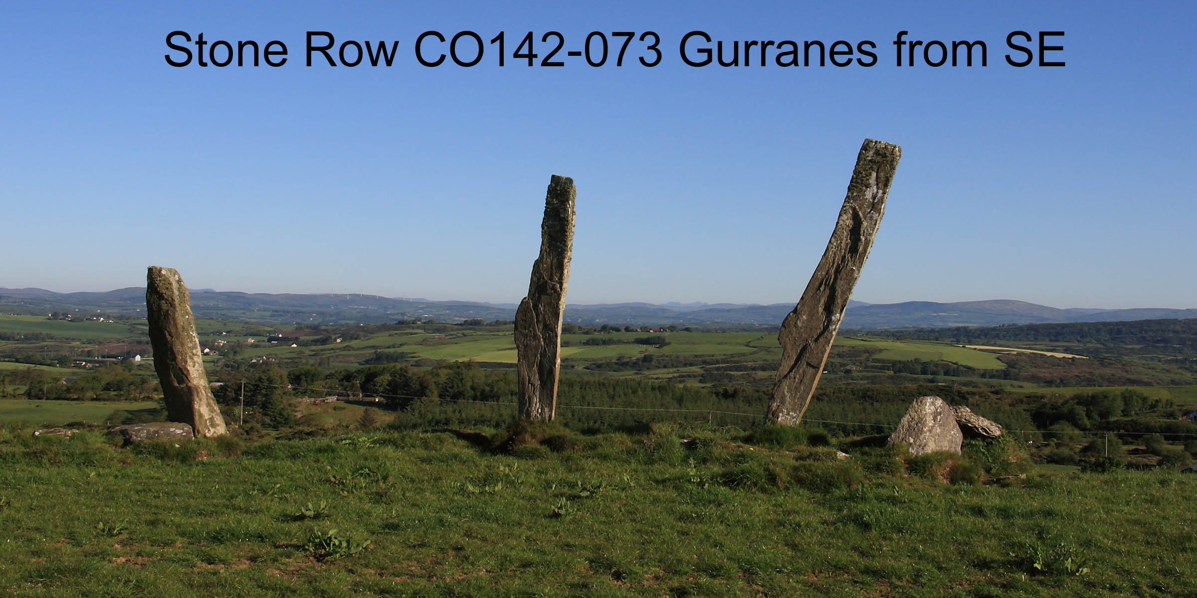
 Gurranes Stone Row is just west of Castletownshend and known locally as the "five fingers" but sometimes called the "three fingers" as there are now only three stones upright.
This striking monument is situated on high ground at the north edge of a level terrace just south of a slightly higher ridge crest.
Gurranes Stone Row is just west of Castletownshend and known locally as the "five fingers" but sometimes called the "three fingers" as there are now only three stones upright.
This striking monument is situated on high ground at the north edge of a level terrace just south of a slightly higher ridge crest.
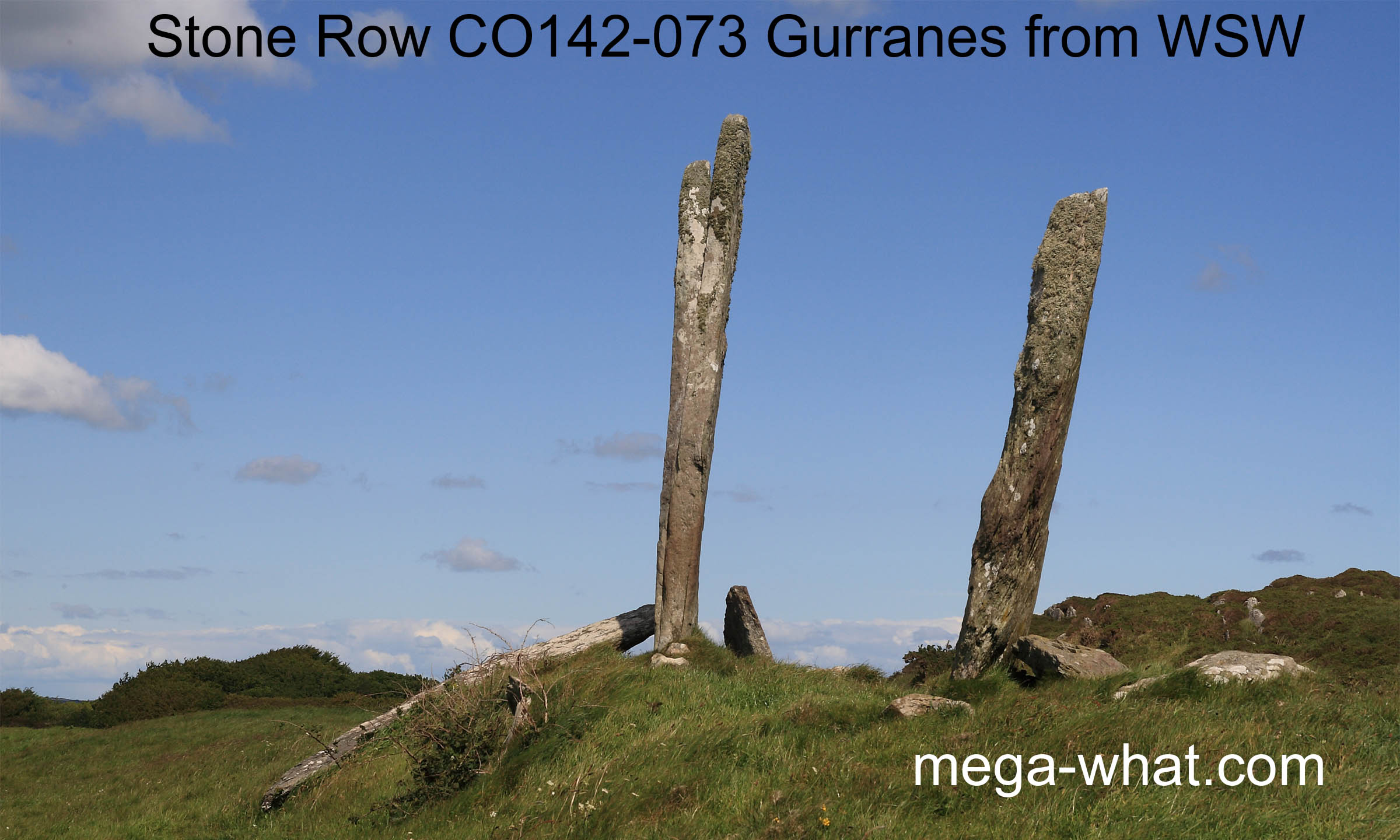 Two tall, thin slabs stand upright and a third "index finger" to the east has fallen.
Just south beside where it fell from is a low slab that probably helped support it. At the west end of the row but offset to the south is the "little finger".
The original east most "thumb" was removed to the grounds of the Castletownshend estate in the 19th century and still lies there,
measuring 5.3m long, 60x15cm at the top and 90x35cm at the base, making it the tallest stone.
Two tall, thin slabs stand upright and a third "index finger" to the east has fallen.
Just south beside where it fell from is a low slab that probably helped support it. At the west end of the row but offset to the south is the "little finger".
The original east most "thumb" was removed to the grounds of the Castletownshend estate in the 19th century and still lies there,
measuring 5.3m long, 60x15cm at the top and 90x35cm at the base, making it the tallest stone.
So what we seem to have had here was a four-stone row of tall slabs with an additional, non-axial, standing stone near its west end.
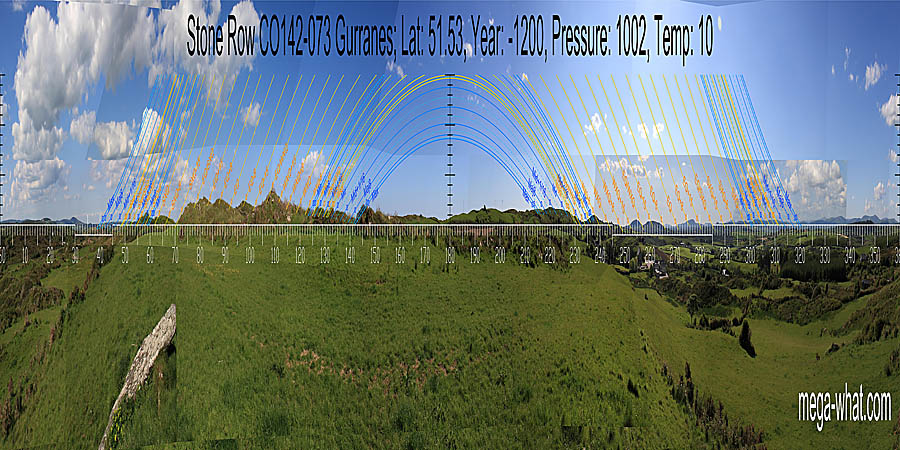 South is indicated by a dip in fairly near ground [Pic].
![[Pic].](Gurranes-S.jpg)
North is indicated by a distant intersect dip [Pic].
![[Pic].](Gurranes-N.jpg)
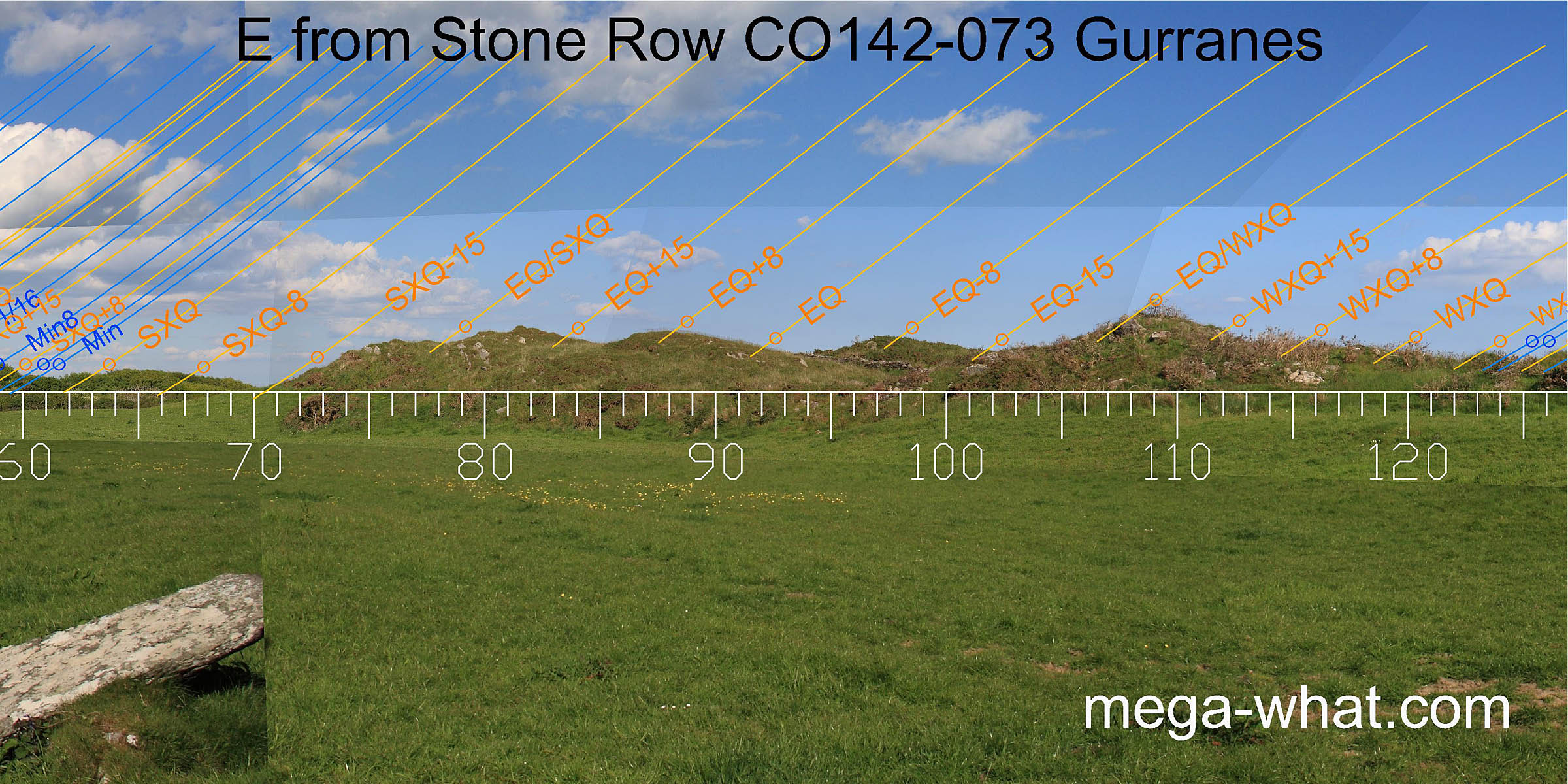
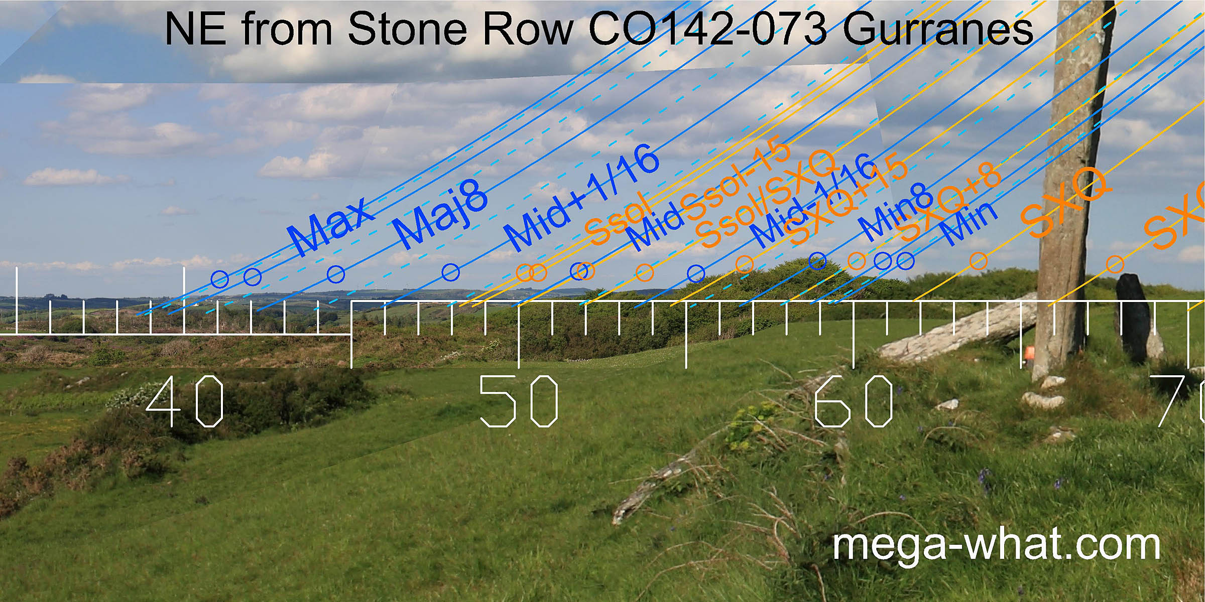 Axially north-eastwards [Pic] is a nearby hill covered with scrub woodland that makes it unsurveyable though the cross-quarter and
minor standstillLunistice positions vary cyclically over an 18.6 year period but are fairly static for more than a year at either end of the range
would occur there.
North of that is a middle distance hill with a lunar sixteenth on its top and the solstice / cross-quarter midpoint at the dip where it intersects with a more distant ridge.
This distant horizon segment is terminated by a small rounded hill at the south edge of a wide dip that is a marker for the major end of the
lunisticeLunistices are the most northerly and southerly moons of the month. The lunar equivalent of solstices - more.
range.
Axially north-eastwards [Pic] is a nearby hill covered with scrub woodland that makes it unsurveyable though the cross-quarter and
minor standstillLunistice positions vary cyclically over an 18.6 year period but are fairly static for more than a year at either end of the range
would occur there.
North of that is a middle distance hill with a lunar sixteenth on its top and the solstice / cross-quarter midpoint at the dip where it intersects with a more distant ridge.
This distant horizon segment is terminated by a small rounded hill at the south edge of a wide dip that is a marker for the major end of the
lunisticeLunistices are the most northerly and southerly moons of the month. The lunar equivalent of solstices - more.
range.
![[Pic]](Gurranes-NEax.jpg)
 The eastern horizon is very local and thus sensitive to exact observer position. Survey was from between the two main uprights.
 The south-eastern lunisticeLunistices are the most northerly and southerly moons of the month. The lunar equivalent of solstices - more.
zone is the closest part, c.35m.
The south-eastern lunisticeLunistices are the most northerly and southerly moons of the month. The lunar equivalent of solstices - more.
zone is the closest part, c.35m.
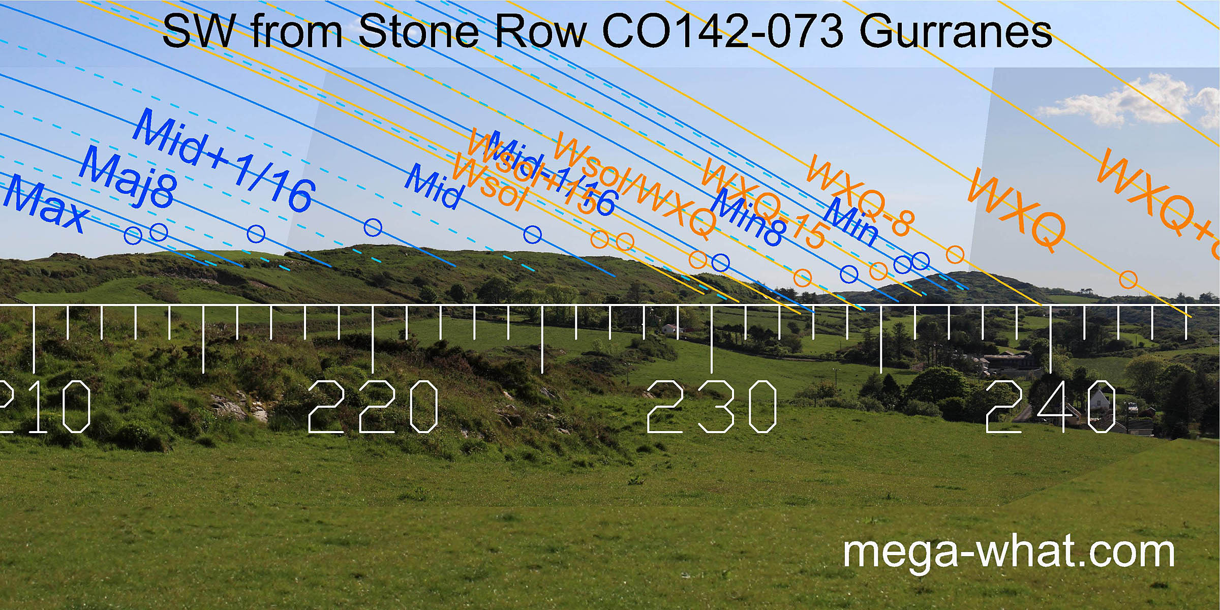 To the south-west, a prominent rounded hill has a quarter-month bracket for the cross-quarter on its top and the lunar minor eighth at its southern foot.
A lunar sixteenth and the solstitial half-month bracket are at the northern basal step of the adjacent long ridge with winter solstice sunset at the top of the slope.
The lunar midpoint and a sixteenth are both at steps, then the major eighth is in a dip before the end of that ridge section marks the major end of the
lunisticeLunistices are the most northerly and southerly moons of the month. The lunar equivalent of solstices - more.
range.
The row axis is just north of the cross-quarters [Pic].
To the south-west, a prominent rounded hill has a quarter-month bracket for the cross-quarter on its top and the lunar minor eighth at its southern foot.
A lunar sixteenth and the solstitial half-month bracket are at the northern basal step of the adjacent long ridge with winter solstice sunset at the top of the slope.
The lunar midpoint and a sixteenth are both at steps, then the major eighth is in a dip before the end of that ridge section marks the major end of the
lunisticeLunistices are the most northerly and southerly moons of the month. The lunar equivalent of solstices - more.
range.
The row axis is just north of the cross-quarters [Pic].
![[Pic]](Gurranes-SWax.jpg)
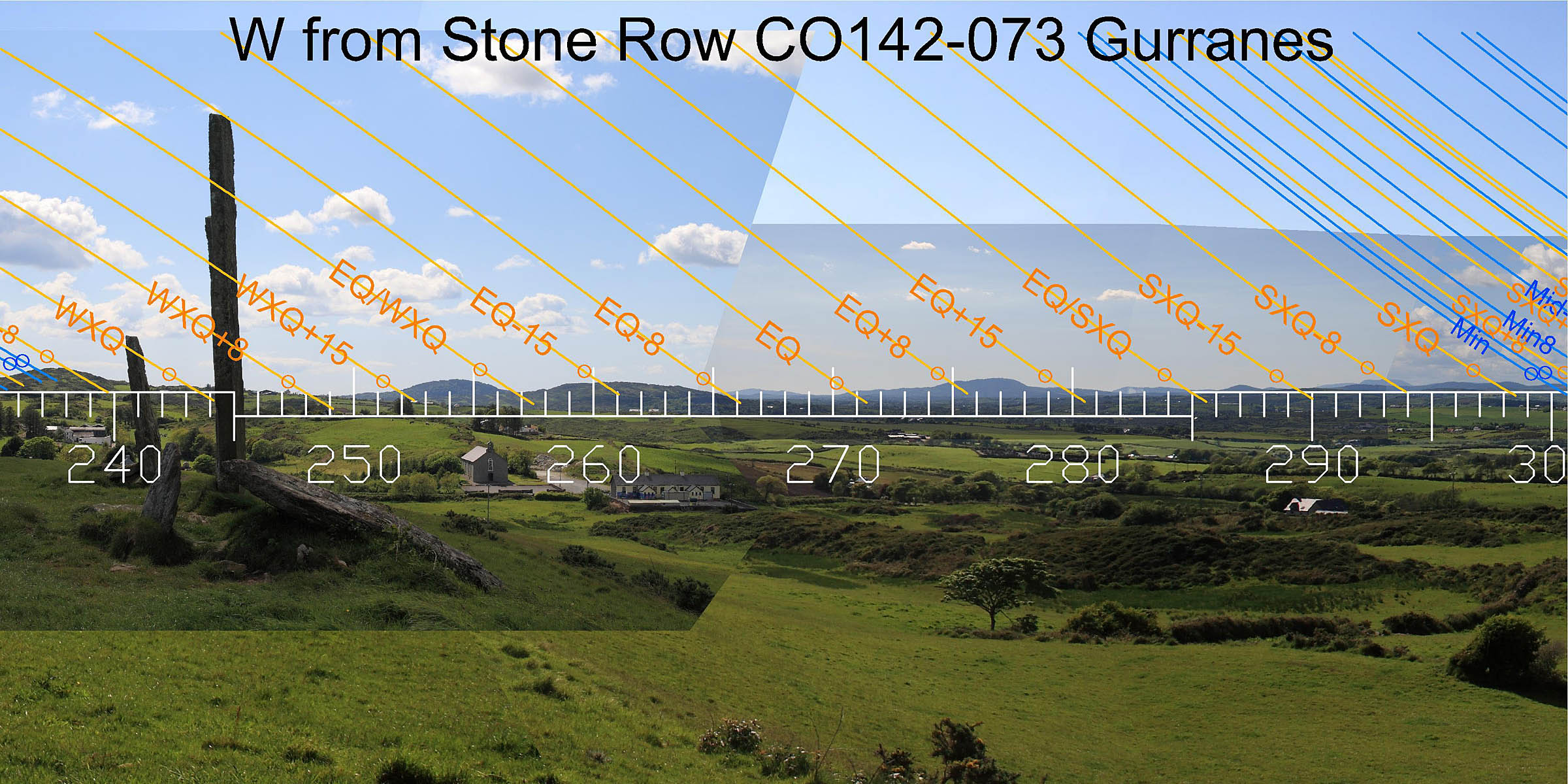 To the west, the cross-quarters are on a bit of a rise between the hilltop and the intersect that mark its quarter-month brackets.
The axis of the extra "little finger" is towards Lick Hill and is a little over two weeks north of the cross-quarters [Pic].
![[Pic]](Gurranes-SWax2.jpg)
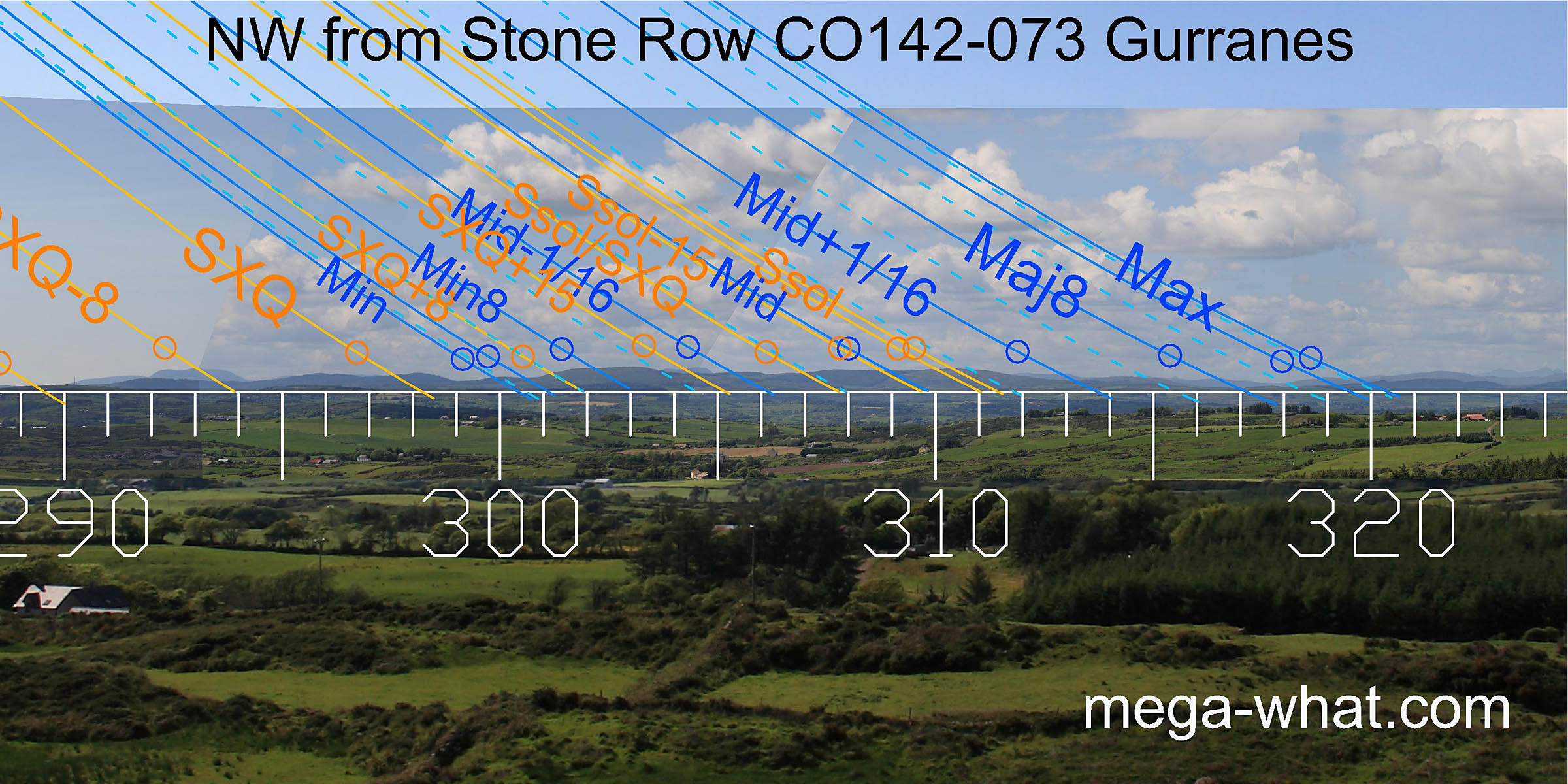 The north-west is a distant horizon. Both ends of the lunisticeLunistices are the most northerly and southerly moons of the month. The lunar equivalent of solstices - more.
range are marked by low rounded hills. the lunar minor eighth and midpoint are both at slight dips in hilltops.
The solstice is on a hilltop at the northern end of a block of high ground that has the cross-quarter at its other end.
The north-west is a distant horizon. Both ends of the lunisticeLunistices are the most northerly and southerly moons of the month. The lunar equivalent of solstices - more.
range are marked by low rounded hills. the lunar minor eighth and midpoint are both at slight dips in hilltops.
The solstice is on a hilltop at the northern end of a block of high ground that has the cross-quarter at its other end.
This splendid stone row is rather isolated, perhaps indicating that it was regarded as good enough to not need supplementing with others in the same territory. The nearest extant Stone Rows are:
- Kilmore 13km to the north-north-west.
- Lissaclarig West 14.4km to the west-north-west.
- Knockawaddra 17.3km to the north-east.
- Gurteenaduige Stone Pair 8.3km north-north-east.
- Barnabah Stone Pair 9.3km west-south-west.
- Keamore Boulder-Burial 7.2km north-north-east.
- Oldcourt Boulder-Burial 8.7km west.
- Drombeg Stone Circle 8.1km east-north-east.
References
- Archaeological Survey of Ireland, record details. www.archaeology.ie/archaeological-survey-ireland
- LYNCH, ANN 1982 Astronomy and Stone Alignments in S.W. Ireland. In Archaeoastronomy in the Old World, edited by D. Heggie, pp.205-213. Cambridge: University Press.
- Ó'NUALLÁIN, SEÁN 1988 Stone Rows in the South of Ireland. Proceedings of the Royal Irish Academy 88c:179-256, p237, no.55.
- POWER, D. et al. 1992 Archaeological Inventory of County Cork, Volume 1: West Cork. Dublin: Stationary Office. p36, no.153.
- RUGGLES, C.L.N. 1999 Astronomy in Prehistoric Britain and Ireland. Newhaven & London: Yale University Press. CKR91.
- RUGGLES, C.L.N. & Burl, H.A.W. 1995 Astronomical Influences on Prehistoric Ritual Architecture in North-Western Europe: The Case of the Stone Rows. Vistas in Astronomy 39:517-528. Oxford: Elsevier Science Ltd.
- RUGGLES, C.L.N. 1994 The Stone Rows of South-West Ireland: A First Reconnaissance. Archaeoastronomy 19 (Journal of the History of Astronomy xxv) S1-S20.