
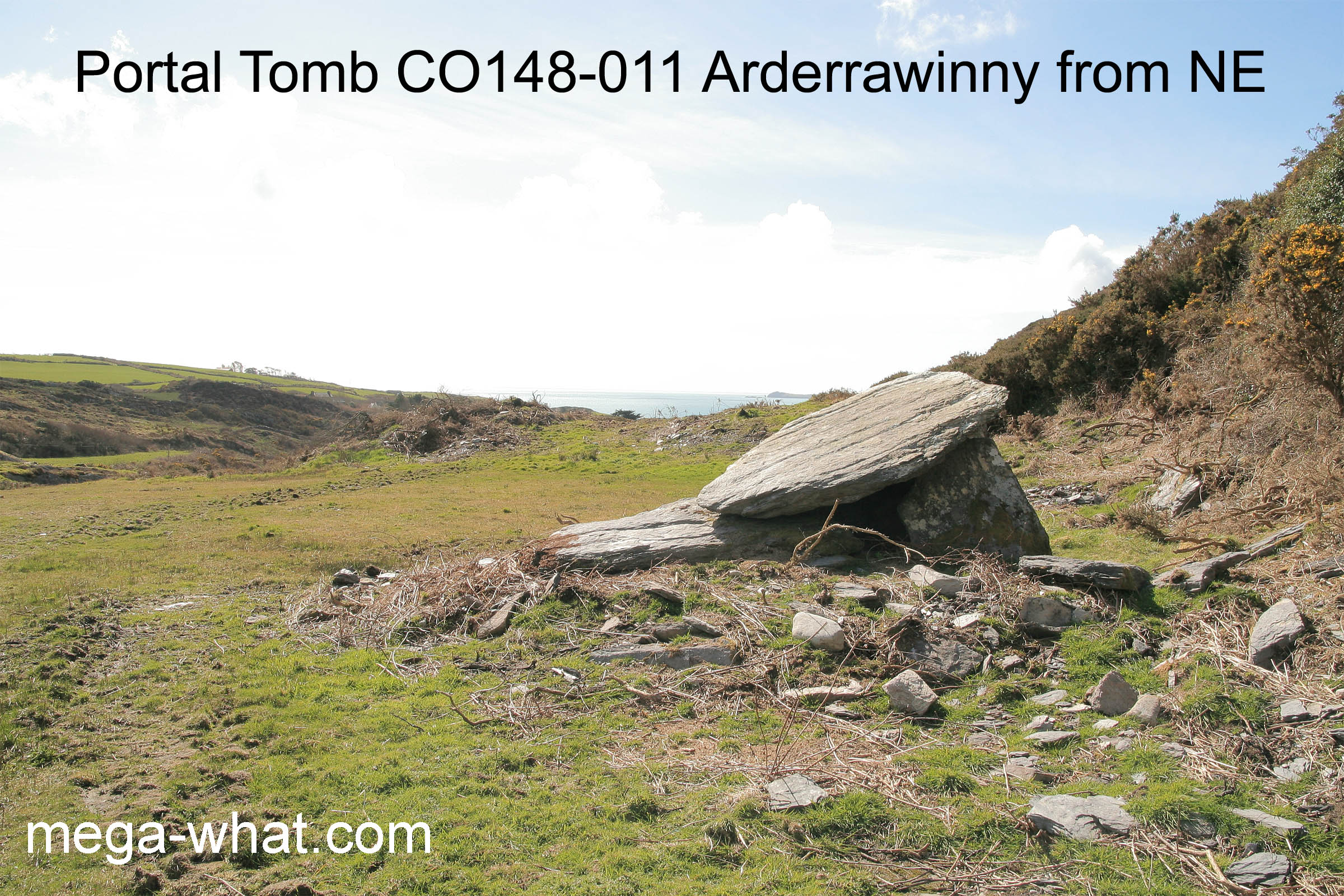
 Arderrawinny Portal Tomb is 5km or so to the west of Schull and a short walk north of the R592.
The site is about 60m above sea level and 1.1km from the coast of Toormore Bay.
There are traces of a mound and the back end of the tomb has collapsed while the front end has skewed to the west.
The land around it has now been cleared but the tomb was very overgrown when the survey was originally done.
Arderrawinny Portal Tomb is 5km or so to the west of Schull and a short walk north of the R592.
The site is about 60m above sea level and 1.1km from the coast of Toormore Bay.
There are traces of a mound and the back end of the tomb has collapsed while the front end has skewed to the west.
The land around it has now been cleared but the tomb was very overgrown when the survey was originally done.
 South is indicated by the right-hand edge of a hill and its intersect with further ground [Pic].
![[Pic].](Arderrawinny-S.jpg)
North is indicated by a highpoint but is on the right-hand side of it [Pic].
![[Pic].](Arderrawinny-N.jpg)
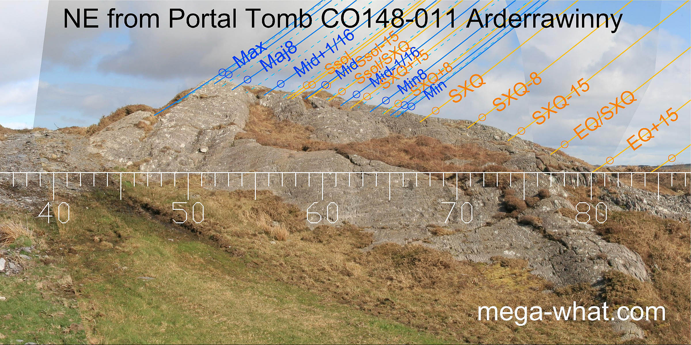 To the north-east, the horizon is very close and formed by a rock outcrop that is the end of a ridge.
Its highest point marks the most extreme northerly moonrise and, because it is so accurate and so close (37m),
there can be little doubt that creation of this alignment was a defining factor in determining the exact position of the tomb.
To the north-east, the horizon is very close and formed by a rock outcrop that is the end of a ridge.
Its highest point marks the most extreme northerly moonrise and, because it is so accurate and so close (37m),
there can be little doubt that creation of this alignment was a defining factor in determining the exact position of the tomb.
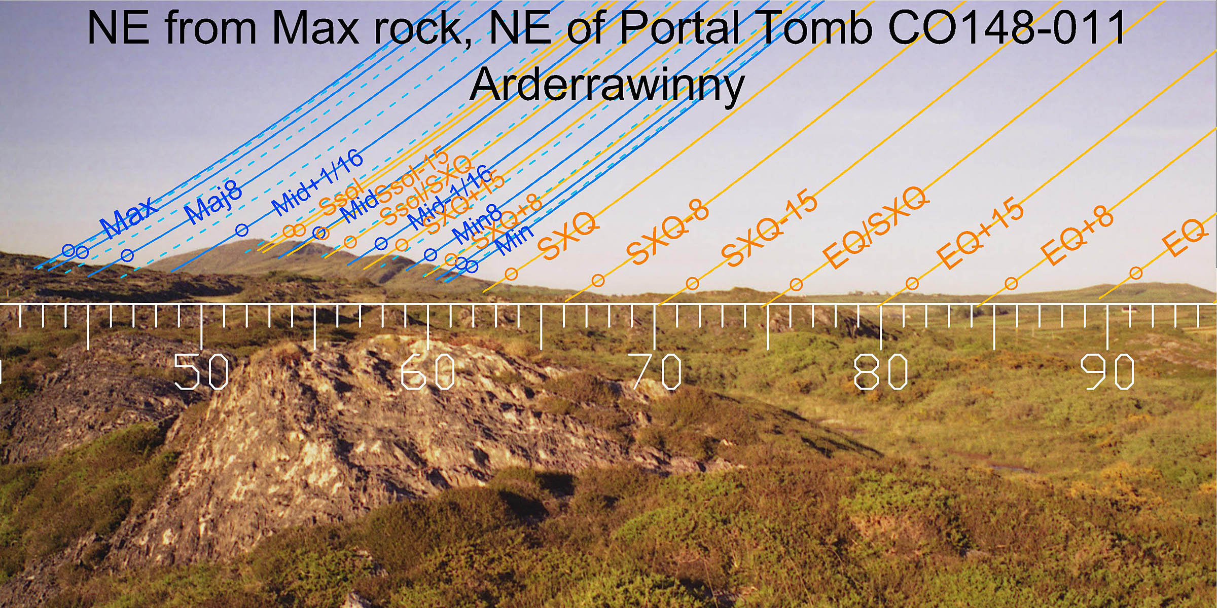 Walking up onto the top of the rock outcrop gives a clear view of the distant horizon and Mt Gabriel.
With the summer cross-quarter at its base and the summer solstice at its top, this mountain also covers more than half of the
lunisticeLunistices are the most northerly and southerly moons of the month. The lunar equivalent of solstices - more. cycle.
The subsidiary summit marking the half-month north of the cross-quarters (SXQ+15) is the site of another megalithic tomb,
at Gubbeen, which was possibly already there when this portal tomb was built.
Walking up onto the top of the rock outcrop gives a clear view of the distant horizon and Mt Gabriel.
With the summer cross-quarter at its base and the summer solstice at its top, this mountain also covers more than half of the
lunisticeLunistices are the most northerly and southerly moons of the month. The lunar equivalent of solstices - more. cycle.
The subsidiary summit marking the half-month north of the cross-quarters (SXQ+15) is the site of another megalithic tomb,
at Gubbeen, which was possibly already there when this portal tomb was built.
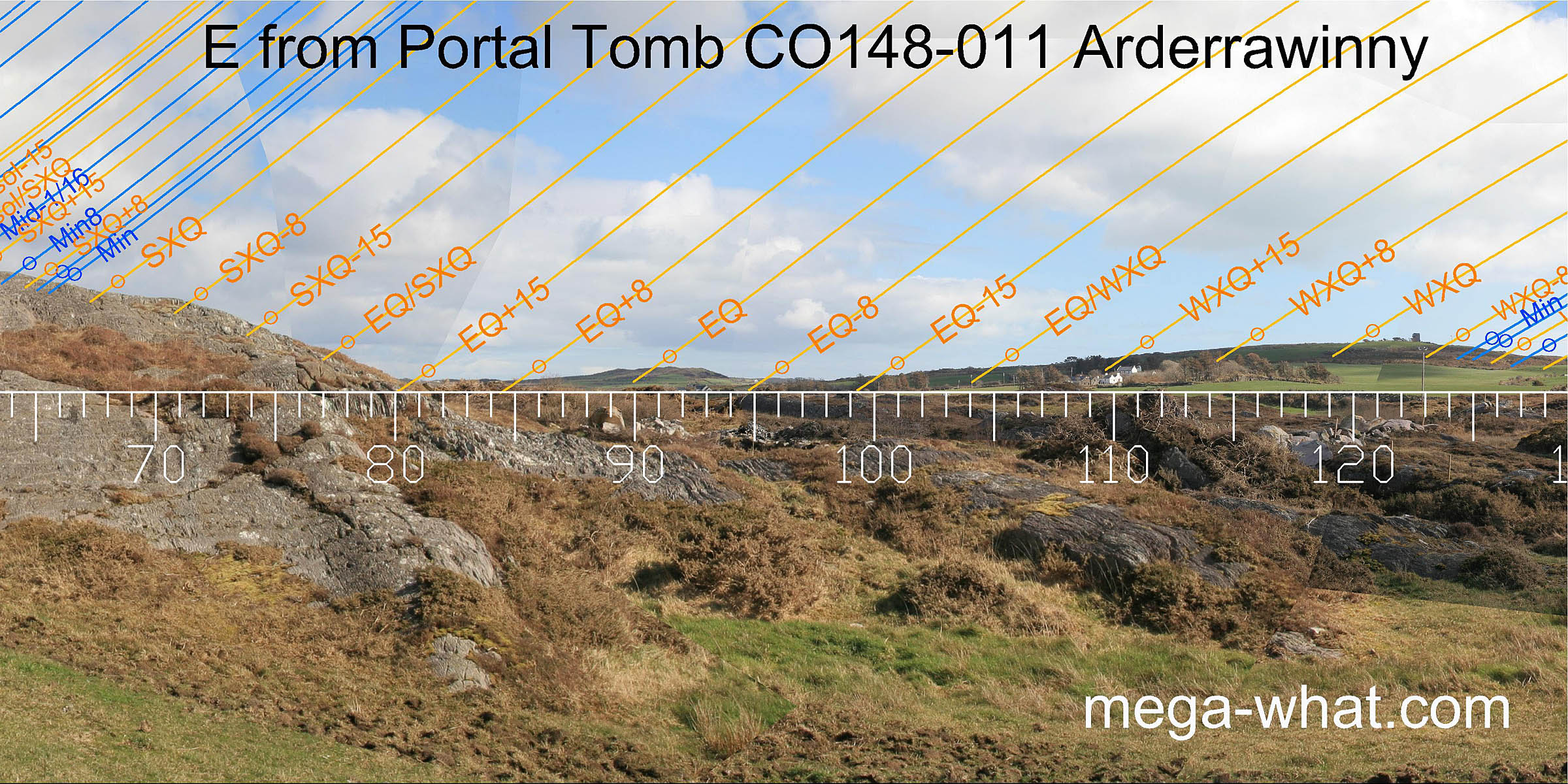 To the east, a distant hill marks the equinox and, from the tomb, the intersection of local and distant horizons is about a half-month north of this.
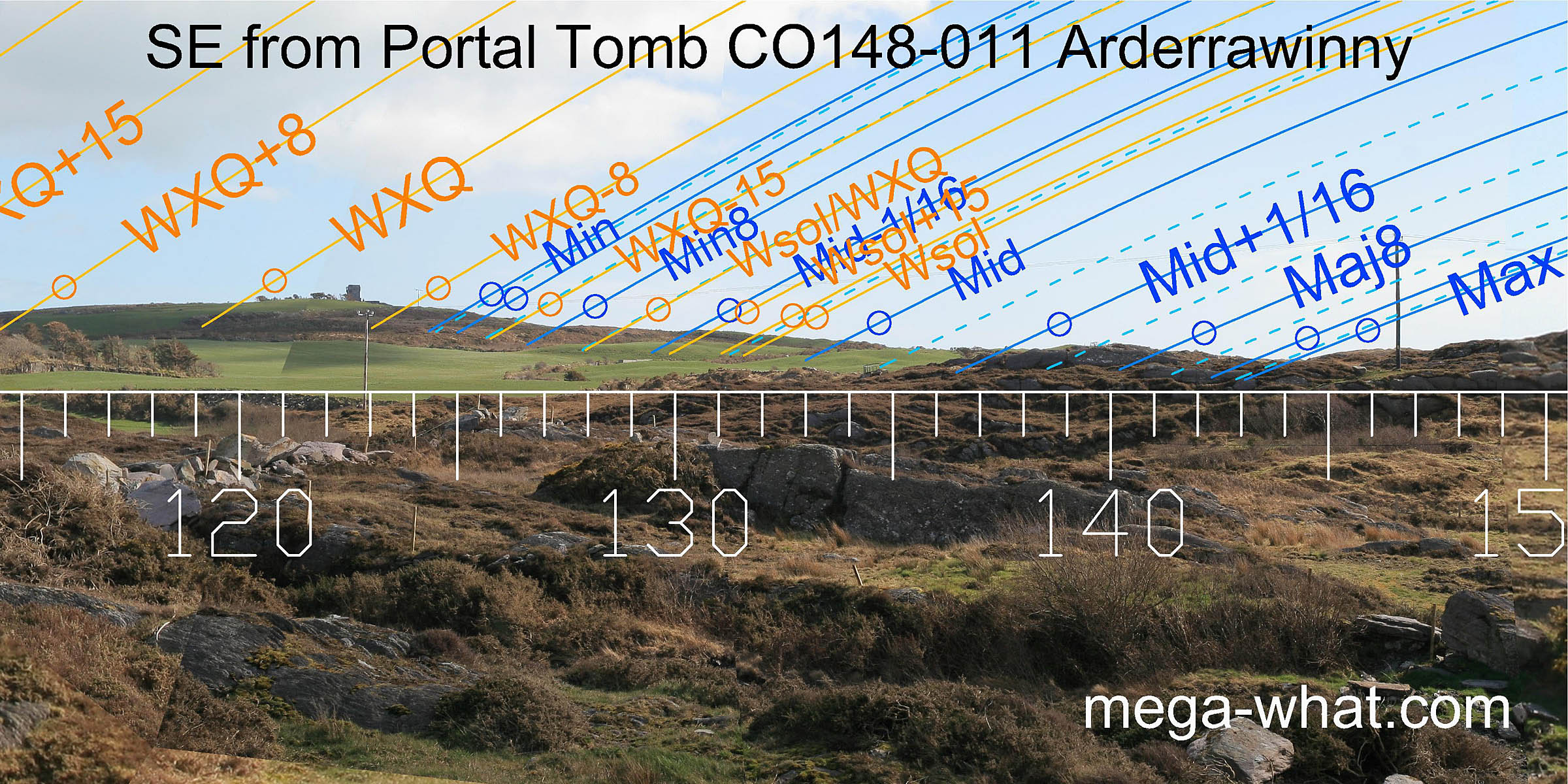 The winter cross-quarters are on a hilltop and indicated by the reverse axis of the tomb [Pic].
Look closely and the cross-quarters are at a slight step to the east of the highest point and the quarter-month to the south is at another step.
The western slope of the south-eastern hill provides various useful solar and lunar markers, with the most extreme southerly moonrise position in the bottom dip.
This hill is nearby (1.4km) so it is likely that it formed part of the territory of the tomb builders and had been cleared of trees for agricultural use.
The winter cross-quarters are on a hilltop and indicated by the reverse axis of the tomb [Pic].
Look closely and the cross-quarters are at a slight step to the east of the highest point and the quarter-month to the south is at another step.
The western slope of the south-eastern hill provides various useful solar and lunar markers, with the most extreme southerly moonrise position in the bottom dip.
This hill is nearby (1.4km) so it is likely that it formed part of the territory of the tomb builders and had been cleared of trees for agricultural use.
![[Pic].](Arderrawinny-SEax.jpg)
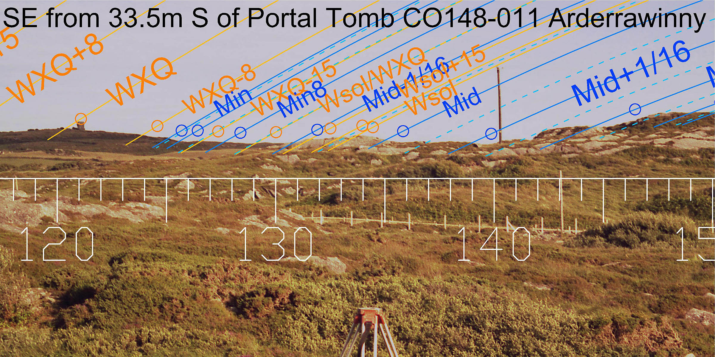 Moving south from the tomb, to the edge of the level terrace on which it stands, changes the south-east view enough to give a new set of useful markers on the same horizon profile.
This complementary utility combined with the accuracy of both sets of markers reinforces the probability that the south-eastern horizon was tree free at time of construction.
Moving south from the tomb, to the edge of the level terrace on which it stands, changes the south-east view enough to give a new set of useful markers on the same horizon profile.
This complementary utility combined with the accuracy of both sets of markers reinforces the probability that the south-eastern horizon was tree free at time of construction.
From this position the eastern horizon is obscured by local ground but Mt Gabriel can be seen to the north-east where it again marks summer solstice sunrise.
 South-west is Toormore Bay, and the moonsets at the major end of the lunistice cycle occur on the sea horizon.
This would not be a problem as position may be judged from the profile of the coastline, especially in conjunction with a beam of reflected moonlight pointing across the bay.
South-west is Toormore Bay, and the moonsets at the major end of the lunistice cycle occur on the sea horizon.
This would not be a problem as position may be judged from the profile of the coastline, especially in conjunction with a beam of reflected moonlight pointing across the bay.
The distant landscape in this direction provides a number of good markers and the intersect between it and the local ground is very sensitive to observer position.
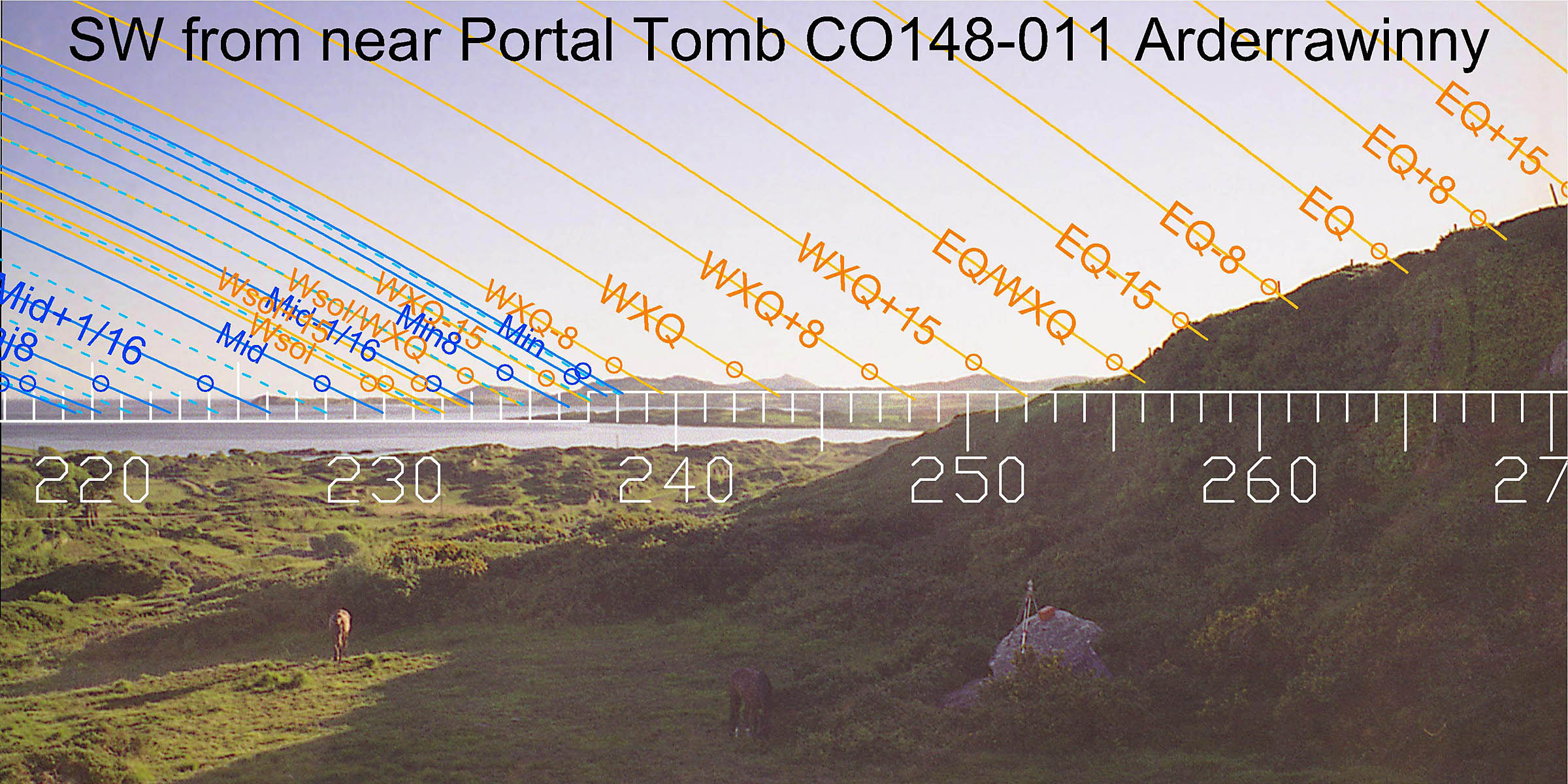 Moving away from the tomb increases the amount that can be seen of this useful south-western horizon.
The distant horizons to both the south-west and north-east axis are far enough away that from anywhere within the general area of the tomb their declination values are essentially the same.
In contrast, the south-east is near enough that its astronomical utility can be significantly altered by varying the exact observing position.
Moving away from the tomb increases the amount that can be seen of this useful south-western horizon.
The distant horizons to both the south-west and north-east axis are far enough away that from anywhere within the general area of the tomb their declination values are essentially the same.
In contrast, the south-east is near enough that its astronomical utility can be significantly altered by varying the exact observing position.
This picture also shows how the tomb used to be surrounded and partly overgrown with gorse and brambles so that the original survey position had to be on top of the front roof slab.
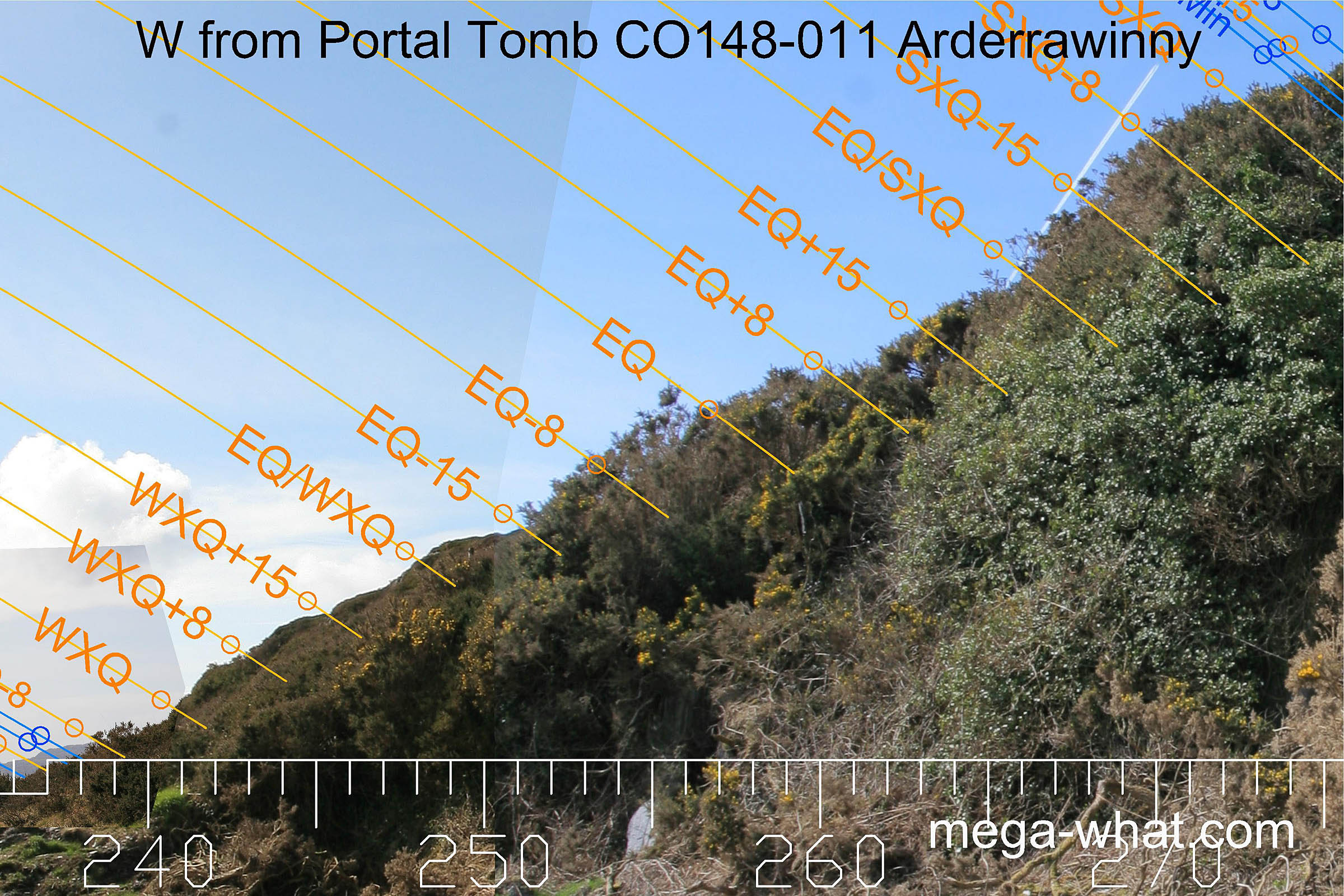 To the west is steeply rising ground. At the bottom it is clear that there is some useful profile but higher up is masked by vegetation.
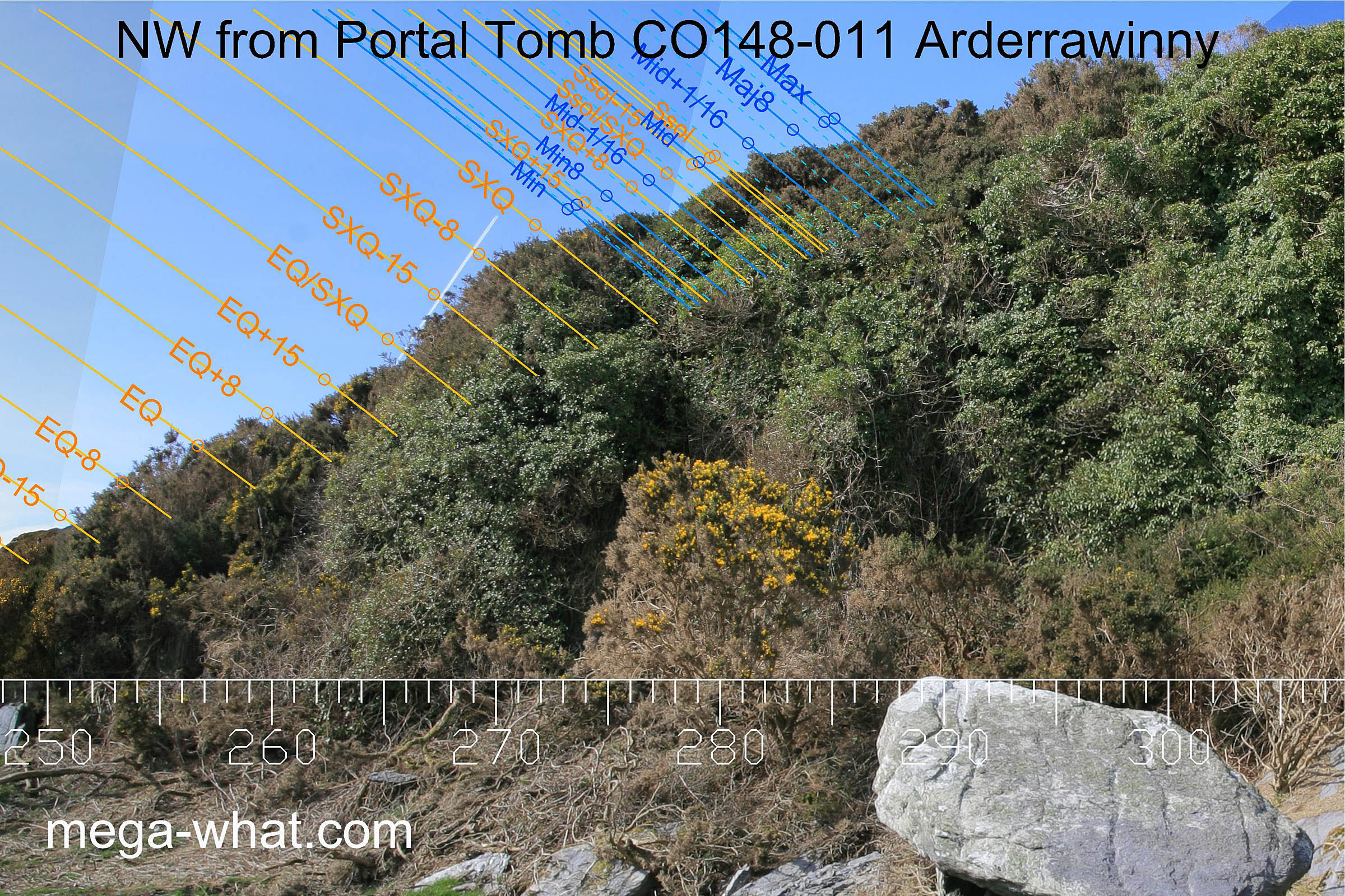 At the top of the cliff above the tomb is another local highpoint which would make a good all-round viewing position.
From it, the barren rocky northern horizon can be seen as well as improved views to the west but no survey has been done from there yet.
Interestingly, this highpoint marks the summer cross-quarter sunset position when viewed from the Max ridgetop.
At the top of the cliff above the tomb is another local highpoint which would make a good all-round viewing position.
From it, the barren rocky northern horizon can be seen as well as improved views to the west but no survey has been done from there yet.
Interestingly, this highpoint marks the summer cross-quarter sunset position when viewed from the Max ridgetop.
To summarise, the tomb has been built within a small area that provides calendrically useful horizons. In determining the exact site and orientation of the tomb, very local horizons have been cleverly manipulated to give markers for the most extreme northerly moon rise and set positions that would not otherwise have been available.
There is only one other Portal Tomb in Co. Cork, 44km (as the crow flies) to the east, at Ahaglaslin. Interestingly that one also has an unusual site and the two form a complementary pair.
References
- Archaeological Survey of Ireland, record details. www.archaeology.ie/archaeological-survey-ireland
- DE VALERA, RUAIDHRÍ & Ó'NUALLÁIN, SEÁN 1982 Survey of the Megalithic Tombs of Ireland, Volume IV: Cork, Kerry, Limerick and Tipperary. Dublin: Stationary Office. p41, no.62.
- POWER, D. et al. 1992 Archaeological Inventory of County Cork, Volume 1: West Cork. Dublin: Stationary Office. p14, no.5.