
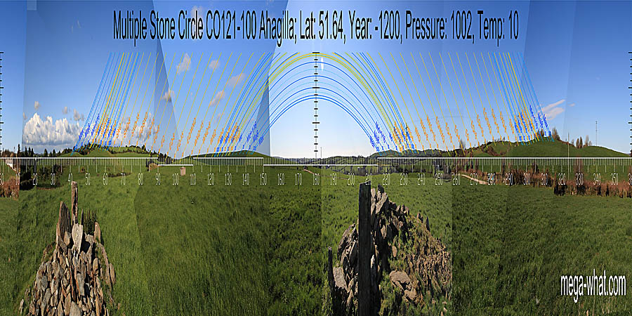
 Ahagilla Stone Circle is 5km or so north-west of Clonakilty and close to the road. Only two stones survive undamaged, fortunately they are the axial and south portal.
The next stone south of this last, though broken, is upright and in situ. A large heap of stones fills the centre of the 7m diameter circle.
Ahagilla Stone Circle is 5km or so north-west of Clonakilty and close to the road. Only two stones survive undamaged, fortunately they are the axial and south portal.
The next stone south of this last, though broken, is upright and in situ. A large heap of stones fills the centre of the 7m diameter circle.
Both South [Pic] and North [Pic] points are in dips and close to the intersect of far and nearer horizons.
![[Pic]](Ahagilla-S.jpg)
![[Pic]](Ahagilla-N.jpg)
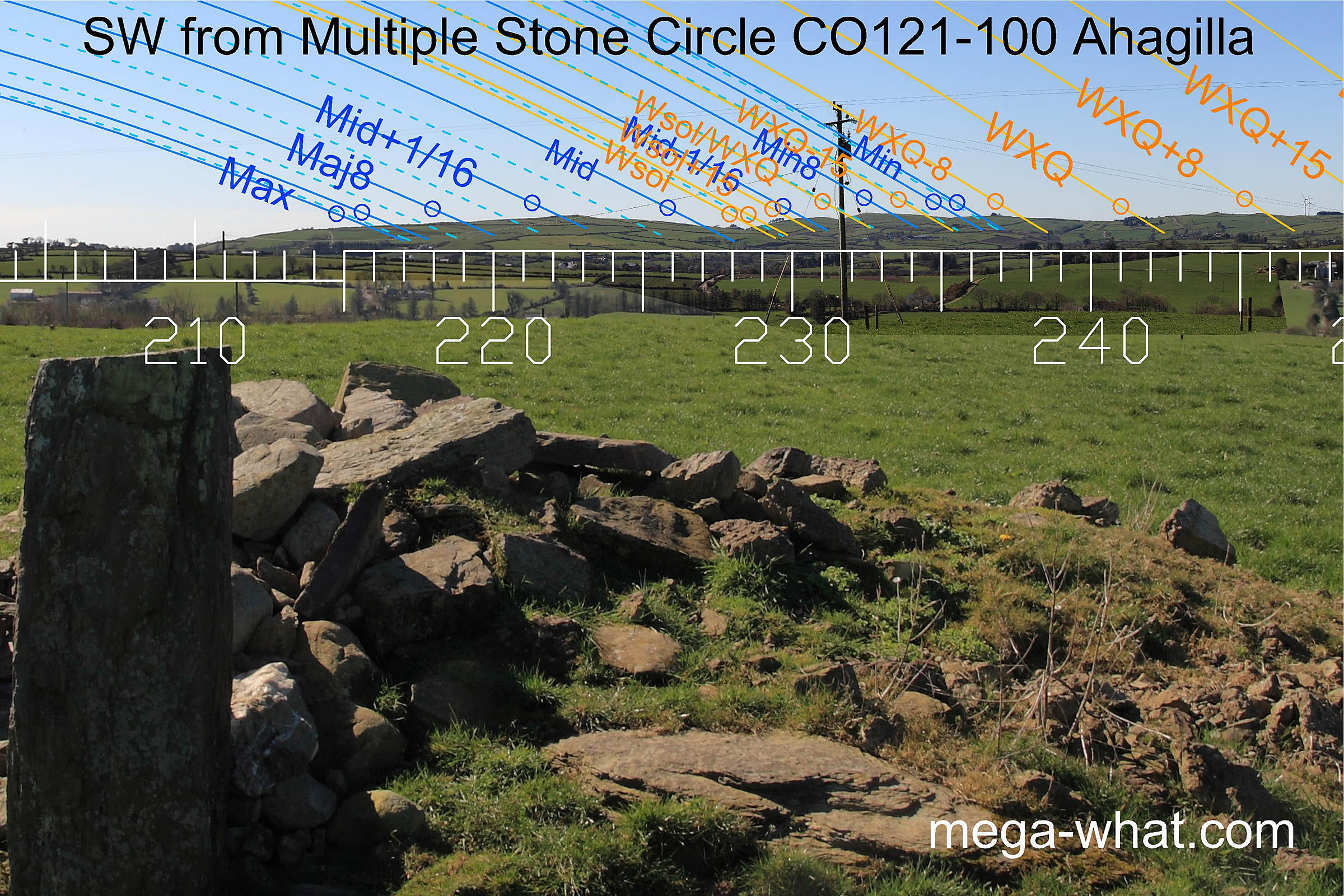 To the south-west is a hill. The prominent notch at its north base marks the winter solstice sunset, the hilltop is a lunar sixteenth and
a break on the south slope is about half a degree beyond the lunar limit. The circle axis indicates this part of the hill.
To the south-west is a hill. The prominent notch at its north base marks the winter solstice sunset, the hilltop is a lunar sixteenth and
a break on the south slope is about half a degree beyond the lunar limit. The circle axis indicates this part of the hill.
A little north of the solstitial notch, a smaller hill is also a lunar sixteenth and then a notch is the solstice / cross-quarter midpoint. The next hilltop is a lunar eighth while the minor end of the lunisticeLunistices are the most northerly and southerly moons of the month. The lunar equivalent of solstices - more. range is at the south end of the next hilltop again.
 West, the intersect of near and distant is half-way between equinox and cross-quarter.
An obvious notch (behind the tree) is a quarter-month south of the equinox, which itself is on the top of the next hump.
West, the intersect of near and distant is half-way between equinox and cross-quarter.
An obvious notch (behind the tree) is a quarter-month south of the equinox, which itself is on the top of the next hump.
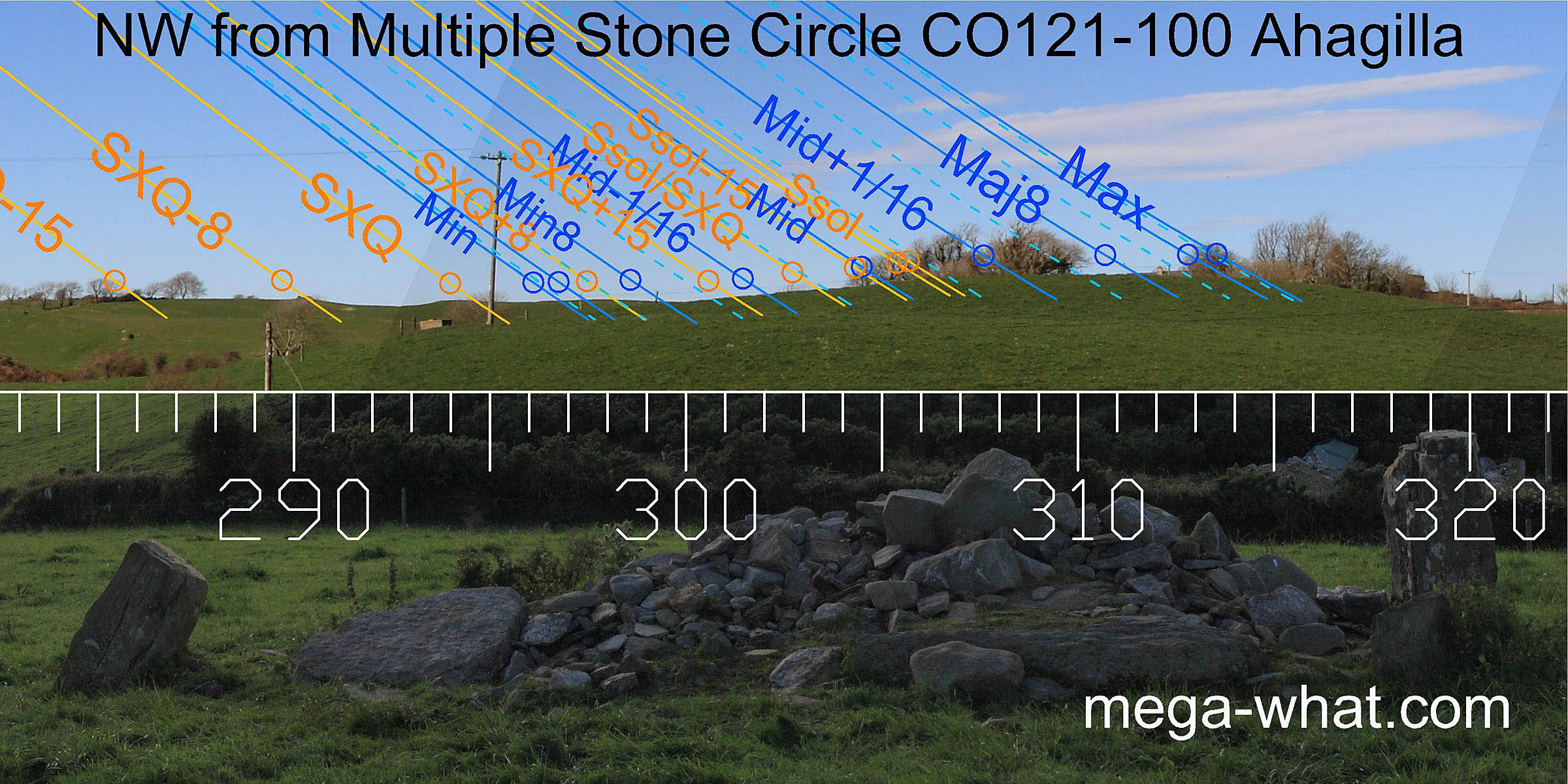 The north-western horizon is the closest one and has helped determine the size of the circle.
Moving from one side to the other changes the azimuth of an observed point in this direction by about two degrees.
The north-western horizon is the closest one and has helped determine the size of the circle.
Moving from one side to the other changes the azimuth of an observed point in this direction by about two degrees.
The basal step of the nearest rise marks the lunar minor eighth when observed from the circle centre. The top of the rise is solstitial when observed from the portals but marks the lunar sixteenth on the major side of the midpoint when observed from the axial stone. Finally, from the portals, the north end of the top marks the major end of the lunistice range.
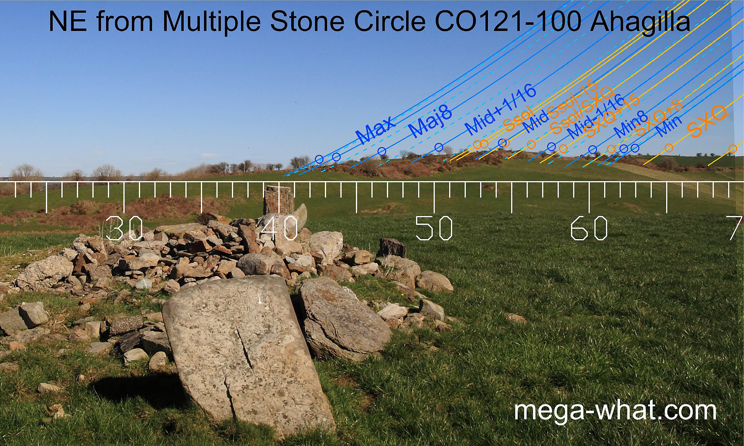 North-eastwards, the axis of the circle points slightly too far north for the most extreme moonrise which occurs at a break in the hillslope.
This indicates that the critical axial orientation is towards the south-west.
North-eastwards, the axis of the circle points slightly too far north for the most extreme moonrise which occurs at a break in the hillslope.
This indicates that the critical axial orientation is towards the south-west.
Lunar midpoint and half-month off the solstice are at the north end of the hilltop and the solstice/cross-quarter halfway marker is the south end of the hilltop. The south basal step of the hill is a minor eighth.
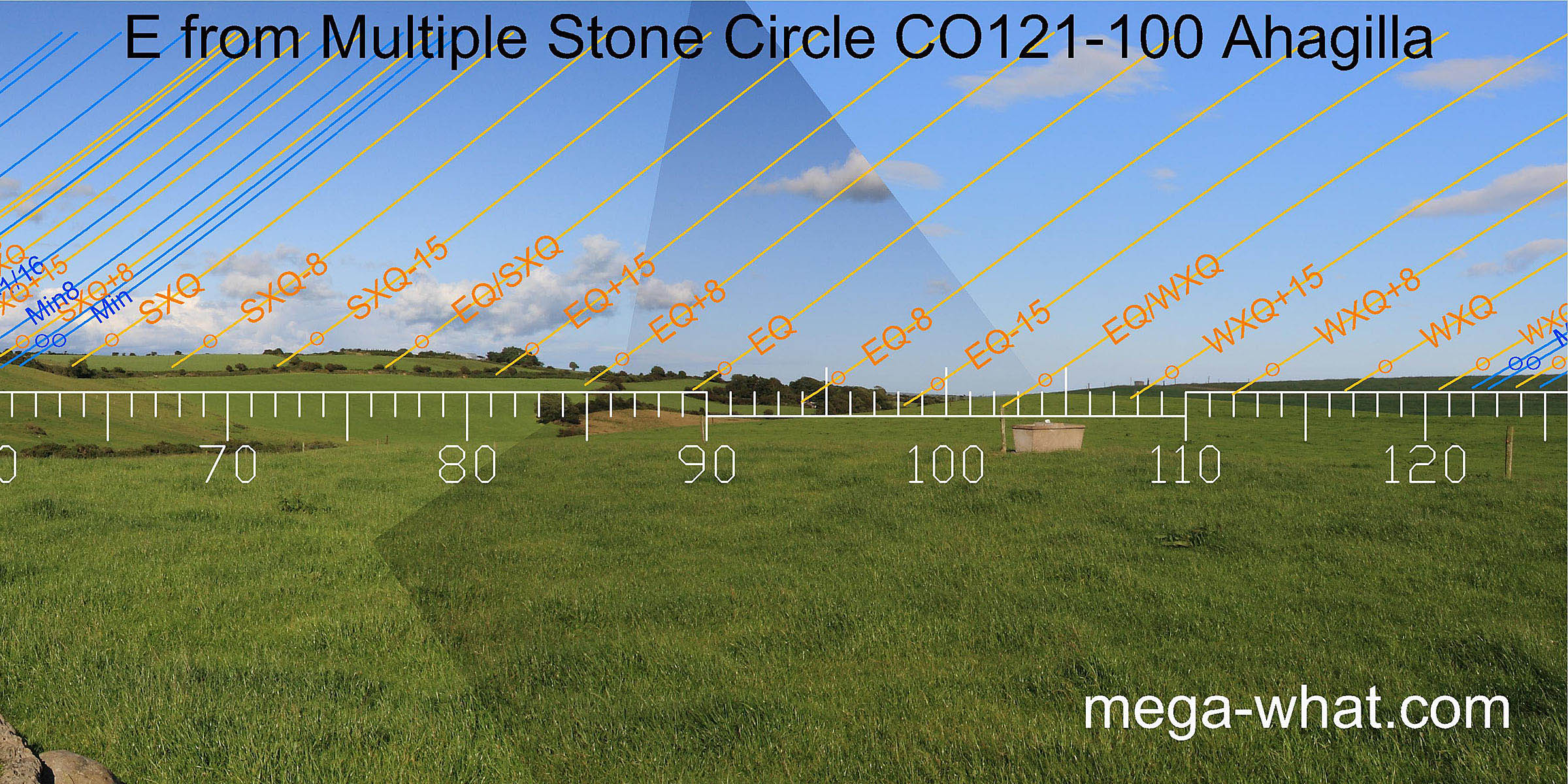 The eastern horizon is the smoothest and least useful but a subtle fit does exist.
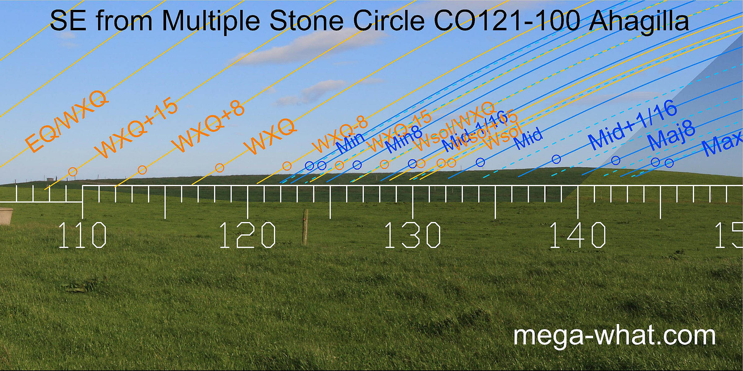 The south-east is highly reclaimed pasture and fairly close. Again, moving from one side of the circle to the other changes the azimuth of an observed point by a couple of degrees.
The highest point is (for the third time) the lunar sixteenth on the major side of the midpoint.
- Ballyvackey Stone Circle is 1.6km south-east (133°) and visible from the local hillcrest.
- Knocks (S) Stone Circle is 3.0km west (278°)
- Knockatlowig Stone Row is 1.3km north-west (294°)
References
- Archaeological Survey of Ireland, record details. www.archaeology.ie/archaeological-survey-ireland
- POWER, D. et al. 1992 Archaeological Inventory of County Cork, Volume 1: West Cork. Dublin: Stationary Office. p395, no.3525.
- RUGGLES, C.L.N. 1999 Astronomy in Prehistoric Britain and Ireland. Newhaven & London: Yale University Press. No.ASC45a.