
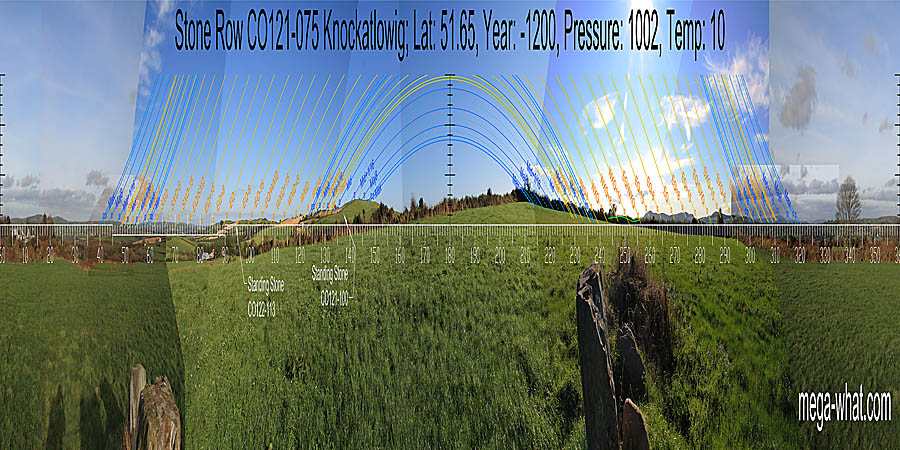
 Knockatlowig Stone Row is between Clonakilty and Ballingurteen. Access is from the east.
South is on the right-hand slope of a dip between major standstillsLunistice positions vary cyclically over an 18.6 year period but are fairly static for more than a year at either end of the range on hilltops [Pic].
![[Pic].](Knockatlowig-S.jpg)
North is marked by a dip in a block of high ground [Pic].
![[Pic].](Knockatlowig-N.jpg)
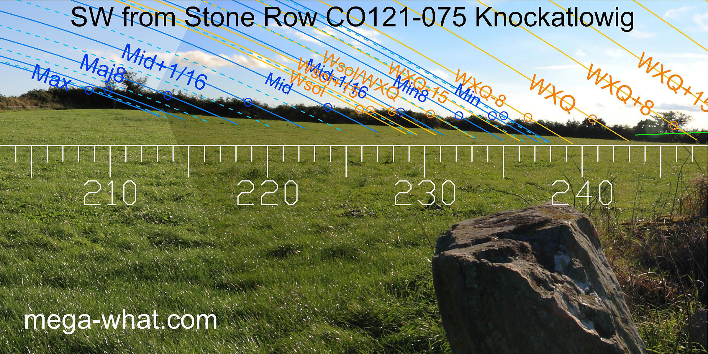 Three stones, largest to the south-west but fallen, point south-westwards uphill towards a field boundary which occupies the local horizon.
This bank may conceal parts of a more distant horizon, namely the ridge south of Carrig Fadda which itself is clearly visible, marking the quarter-month south of the equinox.
Three stones, largest to the south-west but fallen, point south-westwards uphill towards a field boundary which occupies the local horizon.
This bank may conceal parts of a more distant horizon, namely the ridge south of Carrig Fadda which itself is clearly visible, marking the quarter-month south of the equinox.
Axis of the Row seems to be about 236°, consistent with a south-western orientation to the minor end of the lunisticeLunistices are the most northerly and southerly moons of the month. The lunar equivalent of solstices - more. range. South of this, the local hilltop is close to the lunar maximum but accurate survey is not possible.
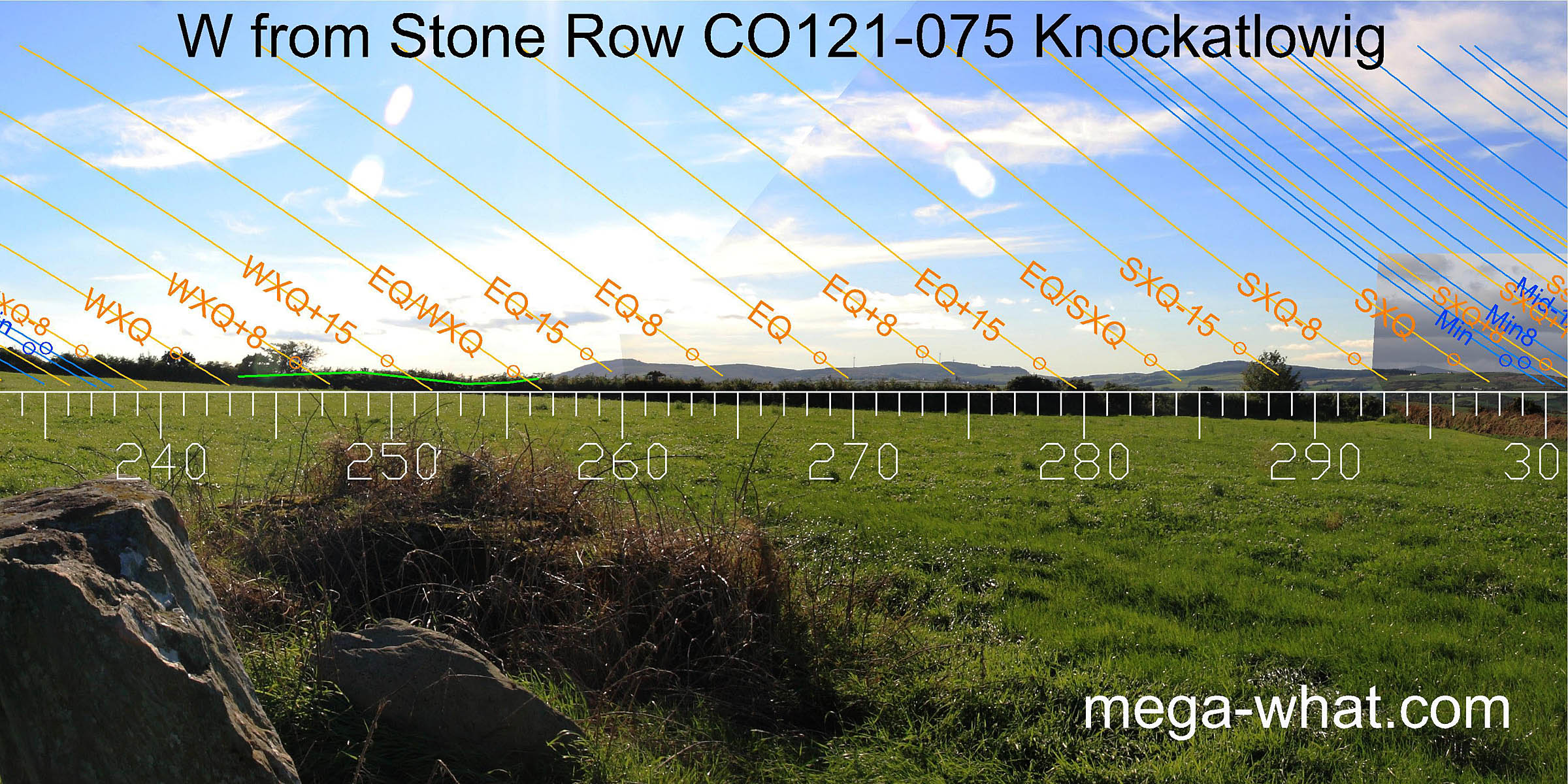 North of Carrig Fadda is an undulating horizon but the next really good point is the half-month north of the equinox, in a large dip.
Further north again, Nowen Hill begins some distant horizon and summer cross-quarters are at its northern intersect with nearer ground.
 North-west from Nowen Hill, the next quarter-month is at the next intersect and the half-month bracket is at the intersect of middle and distant horizons.
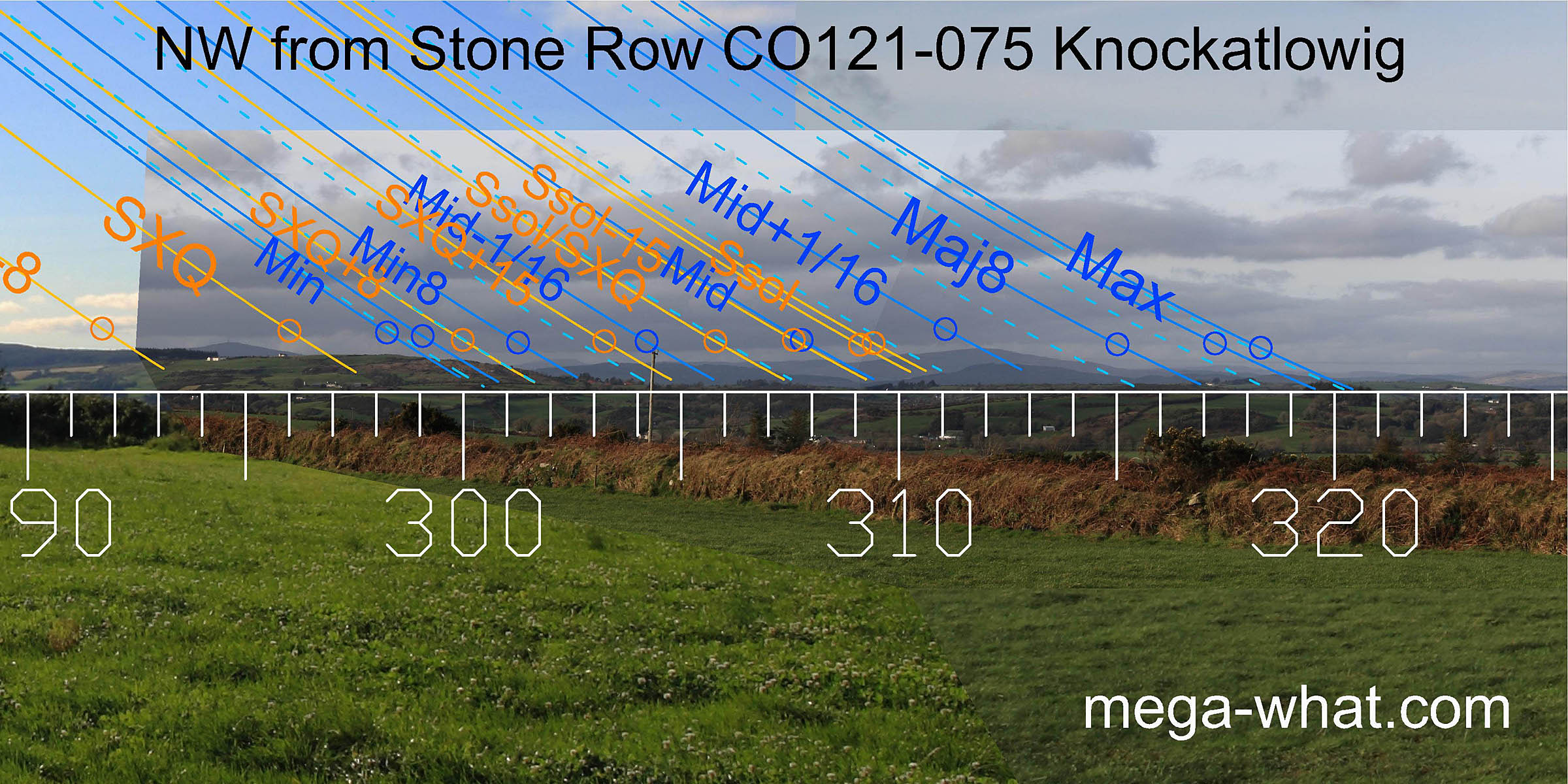
Next comes a prominent hill, Shehy More. The dip at its western base marks the half-month bracket for the summer solstice and also the lunar midpoint.
Its top marks the next lunar sixteenth.
North-west from Nowen Hill, the next quarter-month is at the next intersect and the half-month bracket is at the intersect of middle and distant horizons.
Next comes a prominent hill, Shehy More. The dip at its western base marks the half-month bracket for the summer solstice and also the lunar midpoint.
Its top marks the next lunar sixteenth.
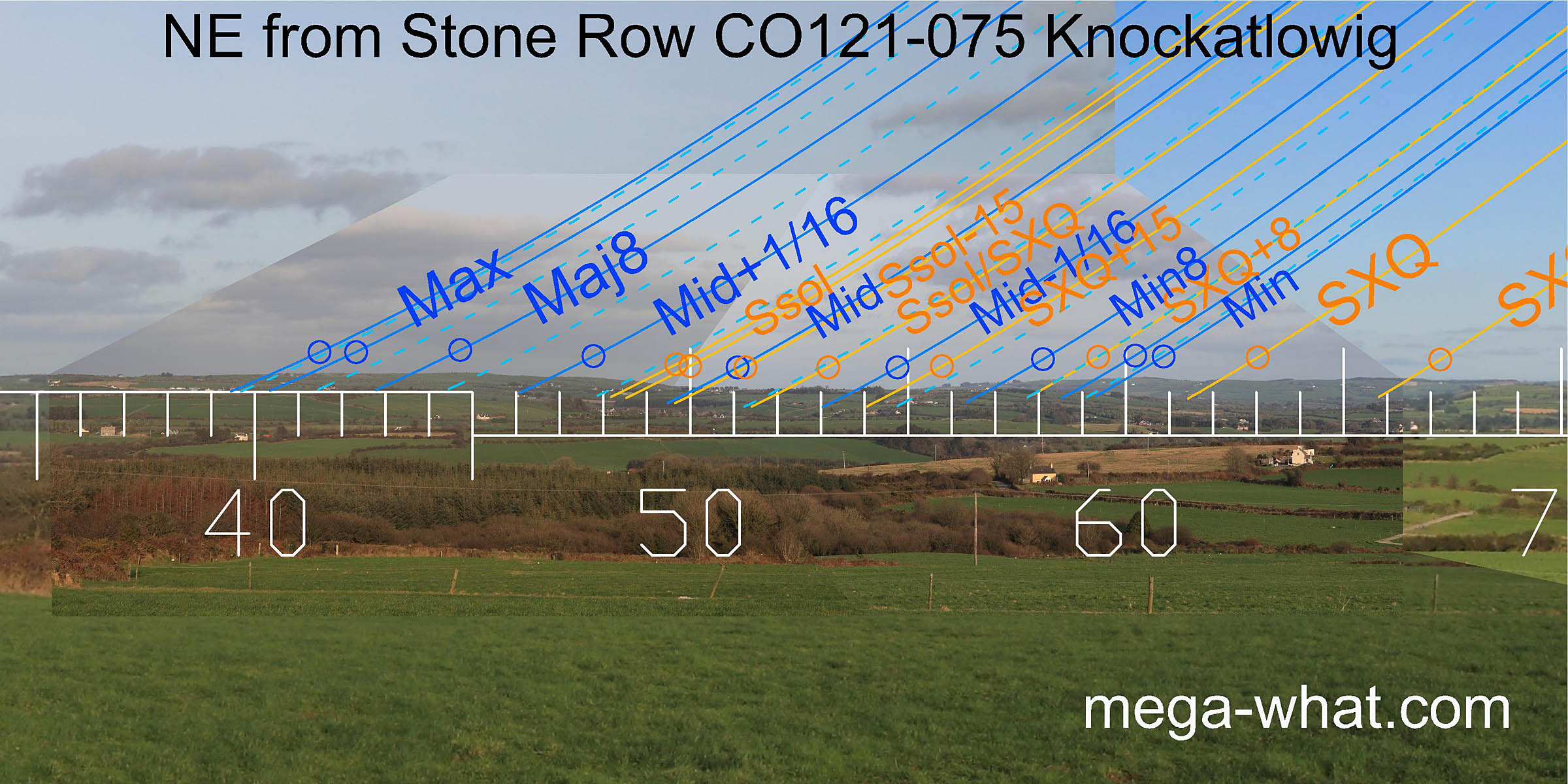 To the north-east is a wide dip and the axis of the row indicates this direction. The centre of the dip is the solstice / cross-quarter midpoint.
At its north end is the lunar midpoint and half-month bracket for the solstice while at its south end is a half-month bracket for the cross-quarter.
To the north-east is a wide dip and the axis of the row indicates this direction. The centre of the dip is the solstice / cross-quarter midpoint.
At its north end is the lunar midpoint and half-month bracket for the solstice while at its south end is a half-month bracket for the cross-quarter.
South of the dip is an obvious small hilltop which marks the minor standstillLunistice positions vary cyclically over an 18.6 year period but are fairly static for more than a year at either end of the range and the cross-quarter is at its south foot. North of the dip is a broad hill which provides some very subtle markers for the major half of the lunisticeLunistices are the most northerly and southerly moons of the month. The lunar equivalent of solstices - more. range.
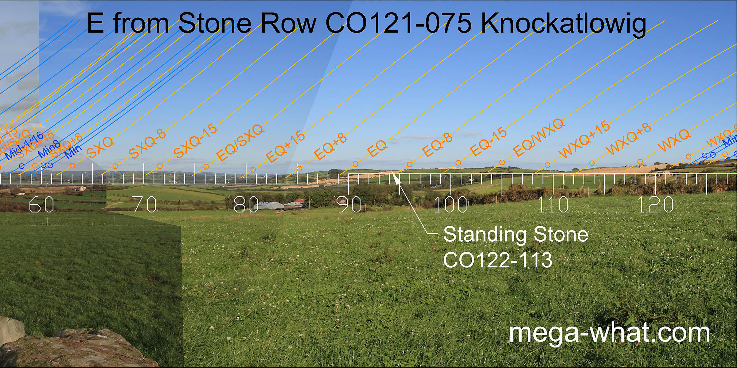 South of summer cross-quarter the distant horizon shows some useful correspondances.
The intersect with nearer ground is a quarter-month north of the equinox which itself occurs at the top of the slope.
In the dip after the equinoctial hill Standing Stone CO122-113 cuts the horizon. The next high point is half-way to the winter cross-quarter.
South of summer cross-quarter the distant horizon shows some useful correspondances.
The intersect with nearer ground is a quarter-month north of the equinox which itself occurs at the top of the slope.
In the dip after the equinoctial hill Standing Stone CO122-113 cuts the horizon. The next high point is half-way to the winter cross-quarter.
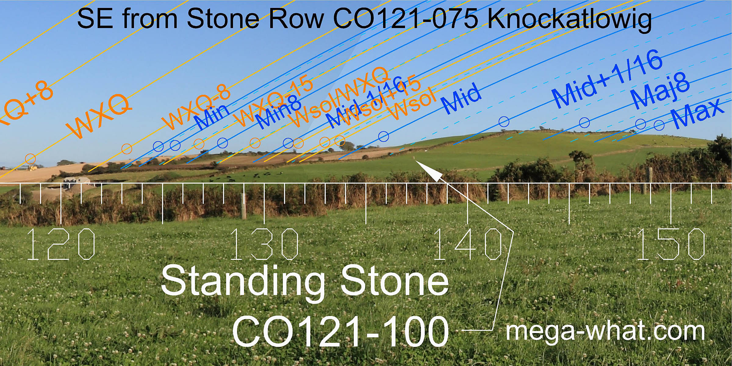 Winter cross-quarter occurs at a slight break in the rising slope.
The break after that is solstitial while the hilltop provides markers for the major eighth and the most extreme southerly moonrise position.
Another Standing Stone (CO121-100) [Pic] is visible on the flank of the hill but no survey has been done from there.
Winter cross-quarter occurs at a slight break in the rising slope.
The break after that is solstitial while the hilltop provides markers for the major eighth and the most extreme southerly moonrise position.
Another Standing Stone (CO121-100) [Pic] is visible on the flank of the hill but no survey has been done from there.
![[Pic]](121100W.jpg)
- Ahagilla Stone Circle is over the hill, 1.3km to the east-south-east.
- The nearest Stone Row is 5.3km to the west-north-west at Knockawaddra and these two form a couple that are a long way from any other rows.
- There is possibly another one between them, currently unsurveyed and classified as Stone Pair CO121-066.
References
- Archaeological Survey of Ireland, record details. www.archaeology.ie/archaeological-survey-ireland
- Ó'NUALLÁIN, SEÁN 1988 Stone Rows in the South of Ireland. Proceedings of the Royal Irish Academy 88c:179-256, p237, no.51.
- POWER, D. et al. 1992 Archaeological Inventory of County Cork, Volume 1: West Cork. Dublin: Stationary Office. p36, no.156.
- RUGGLES, C.L.N. 1999 Astronomy in Prehistoric Britain and Ireland. Newhaven & London: Yale University Press. CKR85.
- RUGGLES, C.L.N. 1996 Stone Rows of Three or More Stones in South-West Ireland. Archaeoastronomy 21 (Journal of the History of Astronomy xxvii) S55-S71.