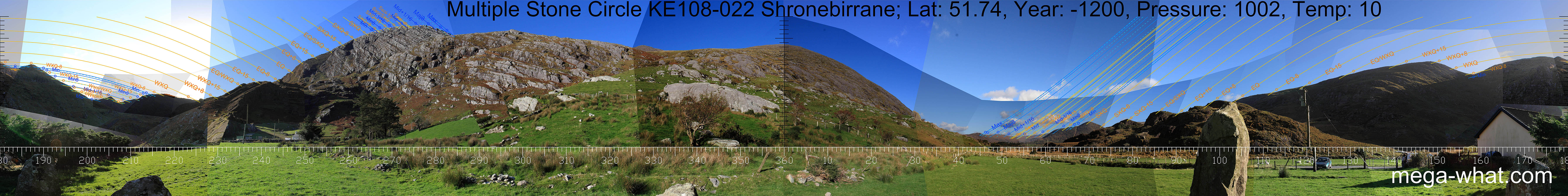
 North is accurately marked by a hilltop.
Northern lunistices span a dip to the east and a hilltop to the west.
South is indicated by a hilltop but is right of it, with high horizons cutting off many southern rises and sets.
Summer solstice sunrise is in the dip at the seaward end of the valley with cross-quarter on the hilltop above it.
Winter solstice sunset is in the lowest dip at the landward end of the valley with winter cross-quarter in a wider
notch at the right-hand intersect with nearer ground.
Lunistice cycle midpoint is at the left hand intersect.
The left intersect of that same ridge with a local hill marks the equinox.
North is accurately marked by a hilltop.
Northern lunistices span a dip to the east and a hilltop to the west.
South is indicated by a hilltop but is right of it, with high horizons cutting off many southern rises and sets.
Summer solstice sunrise is in the dip at the seaward end of the valley with cross-quarter on the hilltop above it.
Winter solstice sunset is in the lowest dip at the landward end of the valley with winter cross-quarter in a wider
notch at the right-hand intersect with nearer ground.
Lunistice cycle midpoint is at the left hand intersect.
The left intersect of that same ridge with a local hill marks the equinox.

Vertical scale x4, maxpic 3200x1600.
Orange lines mark the annual solar round. Lunistice positions over the 18.6 year lunar nodal cycle are blue. More about the Solar Calendar More about the Lunar Calendar More about this placeLook South
Shronebirrane Stone Circle: 360° N centred
North is accurately marked by a hilltop.
Northern lunistices span a dip to the east and a hilltop to the west.
South is indicated by a hilltop but is right of it, with high horizons cutting off many southern rises and sets.
Summer solstice sunrise is in the dip at the seaward end of the valley with cross-quarter on the hilltop above it.
Winter solstice sunset is in the lowest dip at the landward end of the valley with winter cross-quarter in a wider
notch at the right-hand intersect with nearer ground.
Lunistice cycle midpoint is at the left hand intersect.
The left intersect of that same ridge with a local hill marks the equinox.
- Cashelkeelty Stone Circles and Stone Row are just over the ridge, 2.25km to the NNW.
- Drombohilly Stone Circle is c.7km north-north-east.
| Home | Site Lists | Glossary | Survey Data |
Most archaeological monuments are on private property and where not otherwise indicated those wishing to visit a site should seek permission from the landowner.