
 Lettergorman Stone Circle is about 3km south-west of Ballingurteen, as the crow flies.
Situated on a ridge with low, open horizons to the south, It is a very small circle of fairly tall stones and its north portal is fallen.
Lettergorman Stone Circle is about 3km south-west of Ballingurteen, as the crow flies.
Situated on a ridge with low, open horizons to the south, It is a very small circle of fairly tall stones and its north portal is fallen.
South is on the right-hand side of a dip, at the basal step of a hill [Pic]. The eastern luni-solar sequence spans a dip. The western luni-solar sequence spans a double dip, starting and ending on the south slope of a hill. North is in a slight dip of the local ridge [Pic].
![[Pic].](Lettergorman-S.jpg)
![[Pic].](Lettergorman-N.jpg)
 Axially south-west is Carrig Fadda. Its cross surmounted lower top makes a reasonable mark for the major eighth and the lunar extreme is at a step/notch south below it.
The winter solstice occurs at the foot of the northern slope and the next hilltop is a quarter-month beyond the winter cross-quarters which occur at an obvious notch on the slope.
Axially south-west is Carrig Fadda. Its cross surmounted lower top makes a reasonable mark for the major eighth and the lunar extreme is at a step/notch south below it.
The winter solstice occurs at the foot of the northern slope and the next hilltop is a quarter-month beyond the winter cross-quarters which occur at an obvious notch on the slope.
 Westwards, the equinox is marked by the dip of a pass over the local ridge.
 To the north-west is a forested hill. The centre of the lower top is the summer cross-quarter while the centre of the other is beyond the lunar limit.
Thus the whole lunisticeLunistices are the most northerly and southerly moons of the month. The lunar equivalent of solstices - more.
range occurs on the ridge between the two tops. The sidestones both have smooth, wide, curved grooves in their tops indicating this axis.
To the north-west is a forested hill. The centre of the lower top is the summer cross-quarter while the centre of the other is beyond the lunar limit.
Thus the whole lunisticeLunistices are the most northerly and southerly moons of the month. The lunar equivalent of solstices - more.
range occurs on the ridge between the two tops. The sidestones both have smooth, wide, curved grooves in their tops indicating this axis.
 The axial reverse direction north-east along the ridge is obscured by trees but is the rising slope of the local hilltop.
Knockawaddra Stone Row is 900m away in this direction at 64° and its tall stones should perhaps be visible from here.
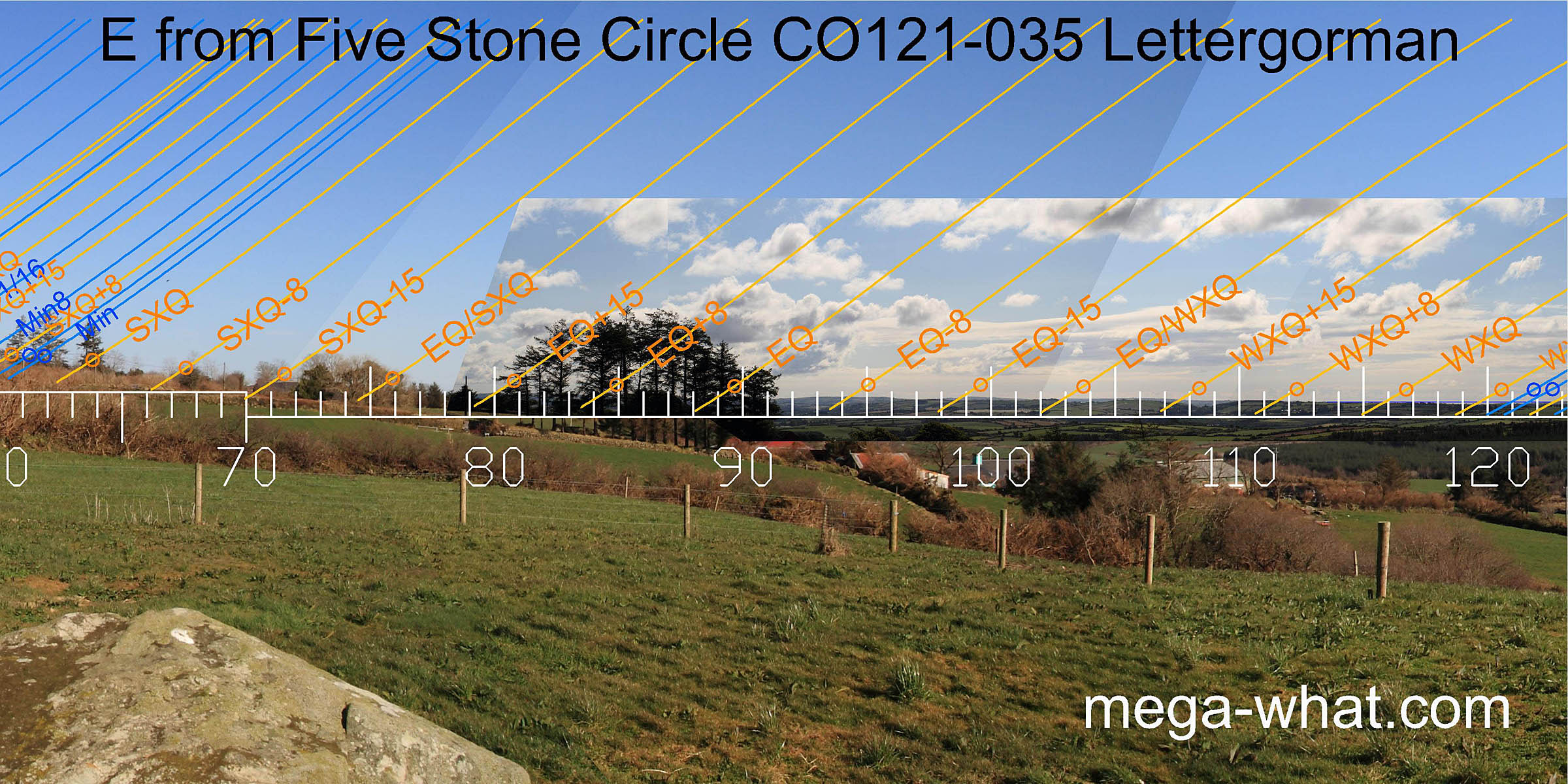 The majority of the eastern horizon is low and gently undulating. It intersect with the slope of the local hill is somewhere close to the equinox / summer cross-quarter midpoint.
 To the south-east is a stretch of sea horizon. Winter cross-quarter sunrise is to its left and the minor end of the
lunisticeLunistices are the most northerly and southerly moons of the month. The lunar equivalent of solstices - more.
range to its right.
The solstice is marked by the intersection of the distant horizon with a nearer hill. The major half of the
lunisticeLunistices are the most northerly and southerly moons of the month. The lunar equivalent of solstices - more.
range runs up the slope but fails to reach the top.
To the south-east is a stretch of sea horizon. Winter cross-quarter sunrise is to its left and the minor end of the
lunisticeLunistices are the most northerly and southerly moons of the month. The lunar equivalent of solstices - more.
range to its right.
The solstice is marked by the intersection of the distant horizon with a nearer hill. The major half of the
lunisticeLunistices are the most northerly and southerly moons of the month. The lunar equivalent of solstices - more.
range runs up the slope but fails to reach the top.
An Anomalous Stone Group is 1.1km to the south and visible from here though almost concealed by a stand of trees.
- Maulatanvally Multiple Stone Circle is 1.8km to the south.
- Carrigagrenane Five Stone Circle is 1.9km to the south.
References
- Archaeological Survey of Ireland, record details. www.archaeology.ie/archaeological-survey-ireland
- Ó'NUALLÁIN, SEÁN 1975 The Stone Circle Complex of Cork and Kerry. Journal of the Royal Society of Antiquaries of Ireland 105:83-131, no.80.
- Ó'NUALLÁIN, SEÁN 1984 A Survey of Stone Circles in Cork and Kerry. Proceedings of the Royal Irish Academy 84c:1-77, p44, no.89.
- POWER, D. et al. 1992 Archaeological Inventory of County Cork, Volume 1: West Cork. Dublin: Stationary Office. p25, no.79.