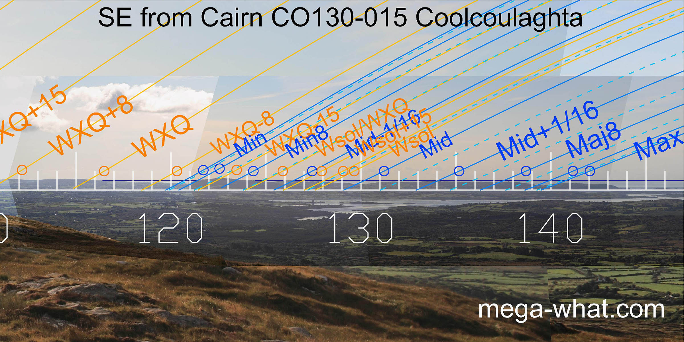
 The south-western lunistice zone spans the dip of the local peninsula end, with both major and minor standstills on hilltops.
Lunar midpoint is on a low hilltop in the middle with winter solstice at a sea / land intersect.
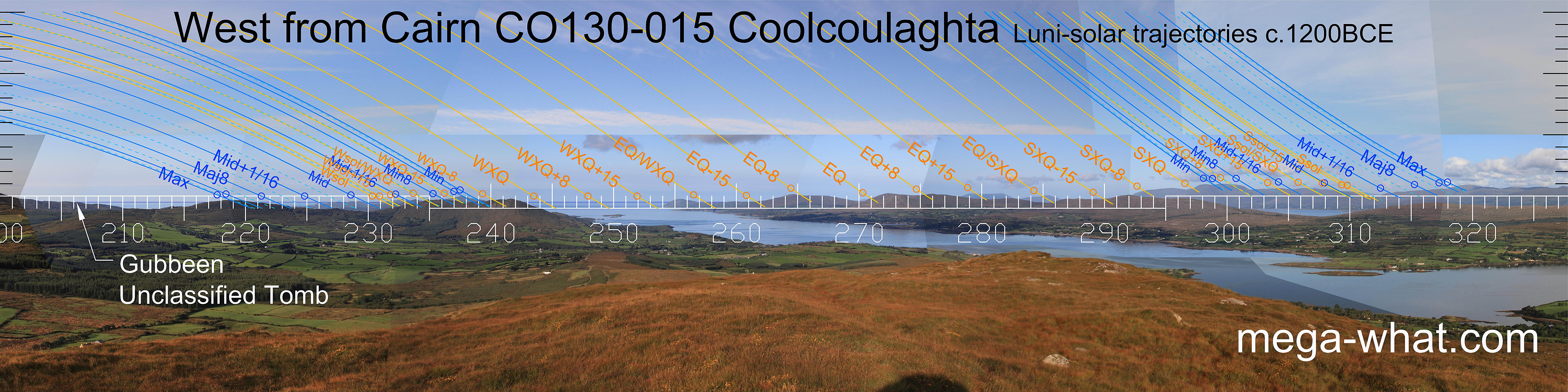
Dunmanus Bay spans a couple of weeks to the north of the winter cross-quarters then a small bight of sea is half-way to the equinox.
The equinox gets good quarter-month brackets. Further north, the equinox / cross-quarter midpoint is on a distant hilltop over a nearer dip.
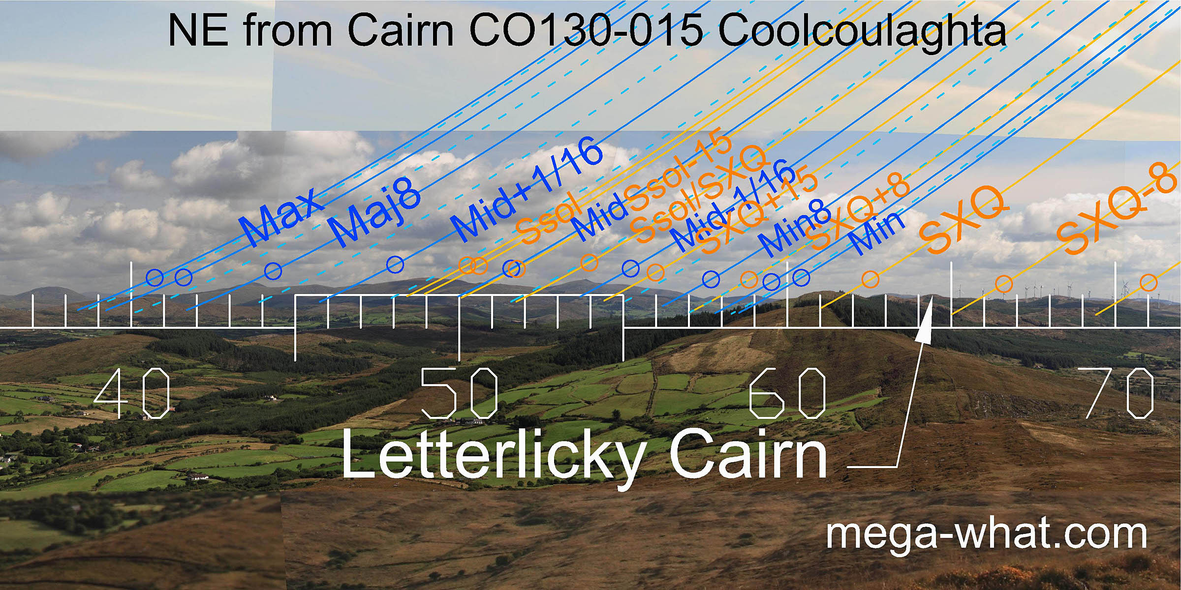
Summer cross-quarters are at the basal step of Hungry Hill which marks the minor end of the lunistice range.
The major end strains to reach the next major hilltop, just as summer solstice sunsets span the ridge end and strain to reach the central dip.
The lunar midpoint and solstitial half-month bracket get a more precise marker.
The south-western lunistice zone spans the dip of the local peninsula end, with both major and minor standstills on hilltops.
Lunar midpoint is on a low hilltop in the middle with winter solstice at a sea / land intersect.
Dunmanus Bay spans a couple of weeks to the north of the winter cross-quarters then a small bight of sea is half-way to the equinox.
The equinox gets good quarter-month brackets. Further north, the equinox / cross-quarter midpoint is on a distant hilltop over a nearer dip.
Summer cross-quarters are at the basal step of Hungry Hill which marks the minor end of the lunistice range.
The major end strains to reach the next major hilltop, just as summer solstice sunsets span the ridge end and strain to reach the central dip.
The lunar midpoint and solstitial half-month bracket get a more precise marker.

Vertical scale x2, maxpic 3200x1600.
Orange lines mark the annual solar round. Lunistice positions over the 18.6 year lunar nodal cycle are blue. More about the Solar Calendar More about the Lunar Calendar More about This PlaceLook East
Coolcoulaghta Cairn: Luni-solar sets
The south-western lunistice zone spans the dip of the local peninsula end, with both major and minor standstills on hilltops.
Lunar midpoint is on a low hilltop in the middle with winter solstice at a sea / land intersect.
Dunmanus Bay spans a couple of weeks to the north of the winter cross-quarters then a small bight of sea is half-way to the equinox.
The equinox gets good quarter-month brackets. Further north, the equinox / cross-quarter midpoint is on a distant hilltop over a nearer dip.
Summer cross-quarters are at the basal step of Hungry Hill which marks the minor end of the lunistice range.
The major end strains to reach the next major hilltop, just as summer solstice sunsets span the ridge end and strain to reach the central dip.
The lunar midpoint and solstitial half-month bracket get a more precise marker.
- Coolcoulaghta Boulder-Burial is 1.7km east-east (36°)
- Coolcoulaghta Standing Stone Pair is 1.1km west (284°)
- Dunbeacon Stone Circle is 1.5km west (276°)
- Letterlicky Cairn is 8km east-east (64°)
| Home | Site Lists | Glossary | Survey Data |
Most archaeological monuments are on private property and where not otherwise indicated those wishing to visit a site should seek permission from the landowner.