
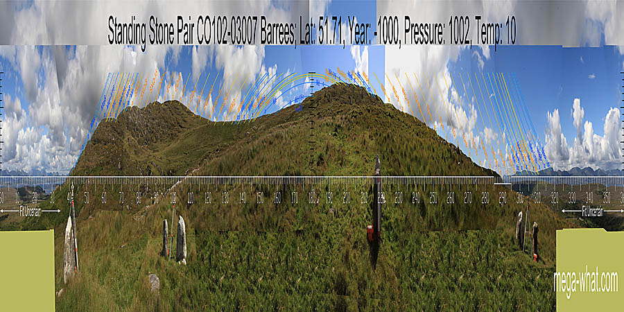
 Barrees Standing Stone Pair is on the north side of the Beara peninsula in West Cork, between Eyeries and Ardgroom.
South of the R571 and a good walk up the mountain side. It was excavated in 2003.
Barrees Standing Stone Pair is on the north side of the Beara peninsula in West Cork, between Eyeries and Ardgroom.
South of the R571 and a good walk up the mountain side. It was excavated in 2003.
South coincides with lunistice sets at a sixteenth on the major side of the midpoint [Pic].
![[Pic].](Barrees-S.jpg)
North is on a distant mountain in the middle of the lowest part of the horizon [Pic].
![[Pic].](Barrees-N.jpg)
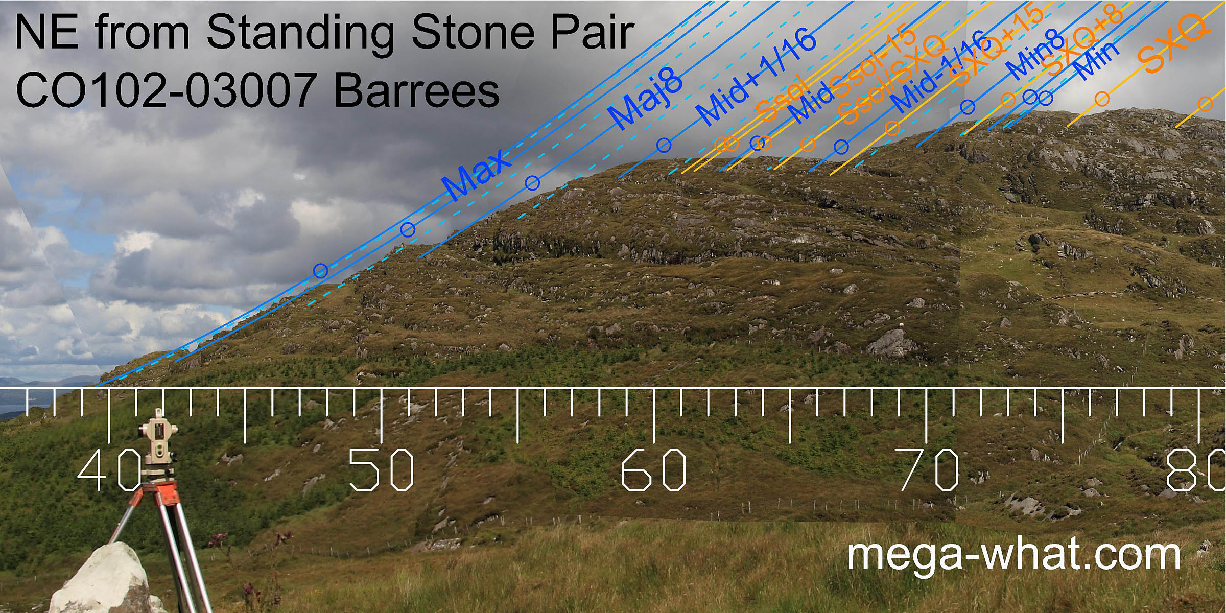 The reverse axis of the pair indicates most extreme northerly moonrise, at the intersect of distant and nearer horizons, with the entire range of the
lunisticeLunistices are the most northerly and southerly moons of the month. The lunar equivalent of solstices - more.
cycle falling on the hill slope.
Summer cross-quarters are in the notch at the top, and summer solstice on the flat section above the lower slope.
The reverse axis of the pair indicates most extreme northerly moonrise, at the intersect of distant and nearer horizons, with the entire range of the
lunisticeLunistices are the most northerly and southerly moons of the month. The lunar equivalent of solstices - more.
cycle falling on the hill slope.
Summer cross-quarters are in the notch at the top, and summer solstice on the flat section above the lower slope.
This is a good example of how a north facing slope may be used to increase accuracy by stretching the amount of azimuth occupied by a degree of declination. Here, the azimuthal difference between summer cross-quarters and the lunar extreme is half as much again as it would be on a flat horizon.
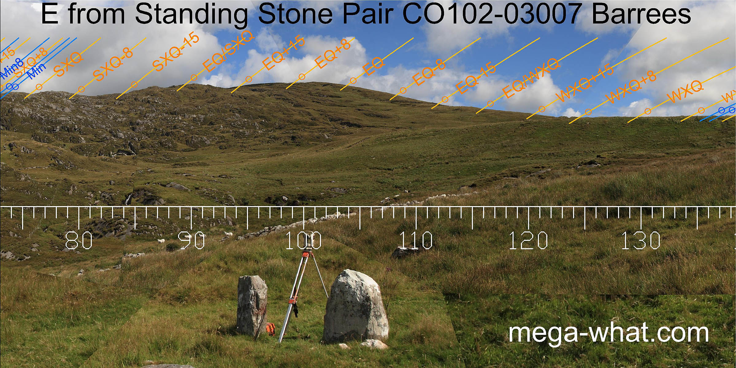 The remainder of the ridge has enough rocky humps and bumps to make a useful measuring device almost as far as the equinox but then the profile becomes rather smooth.
A saddle to the south-east offers some small but nonetheless useful markers.
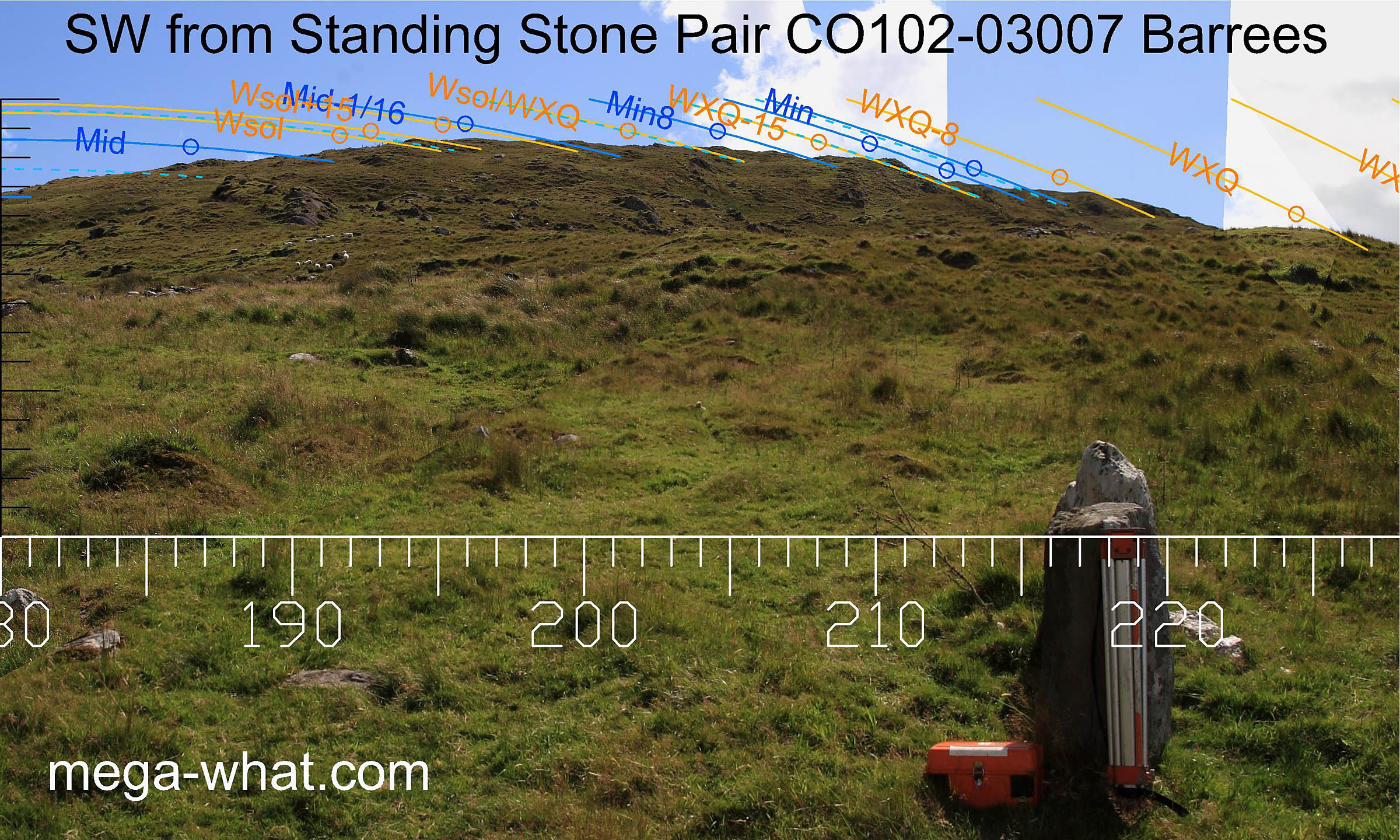
 This southern horizon is so high that everything rises and sets much further south than usual.
So high that for almost half a cycle, about seven years, the most southerly moons of the month never rise at all.
The sixteenth beyond mid-cycle is curious in that having risen and barely cleared the horizon, the moon sets again while still rising, having failed to reach its upper transit (due south).
Similarly, this horizon sector is an extremely sensitive indicator for the adjacent 32ndth.
This southern horizon is so high that everything rises and sets much further south than usual.
So high that for almost half a cycle, about seven years, the most southerly moons of the month never rise at all.
The sixteenth beyond mid-cycle is curious in that having risen and barely cleared the horizon, the moon sets again while still rising, having failed to reach its upper transit (due south).
Similarly, this horizon sector is an extremely sensitive indicator for the adjacent 32ndth.
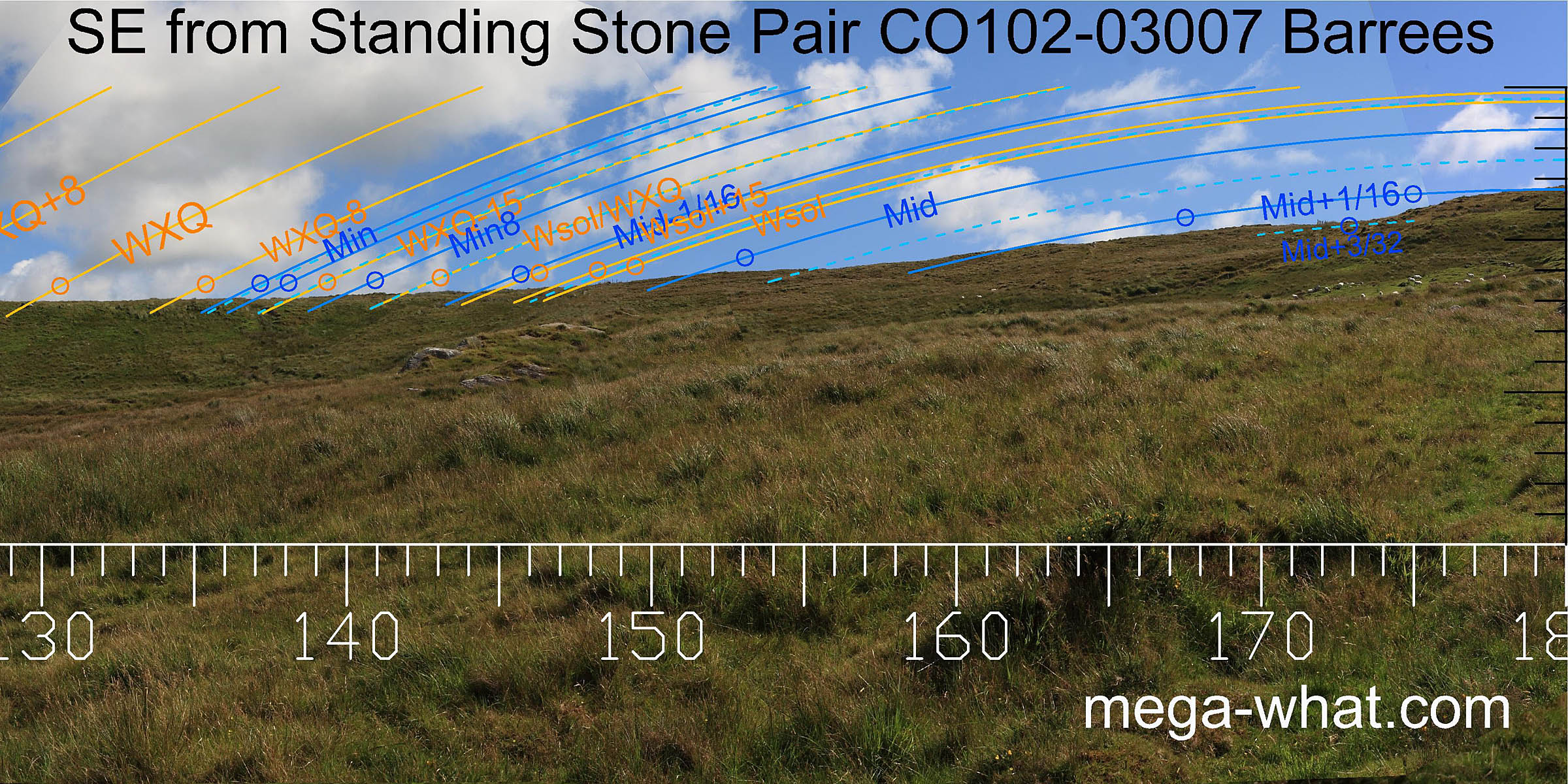
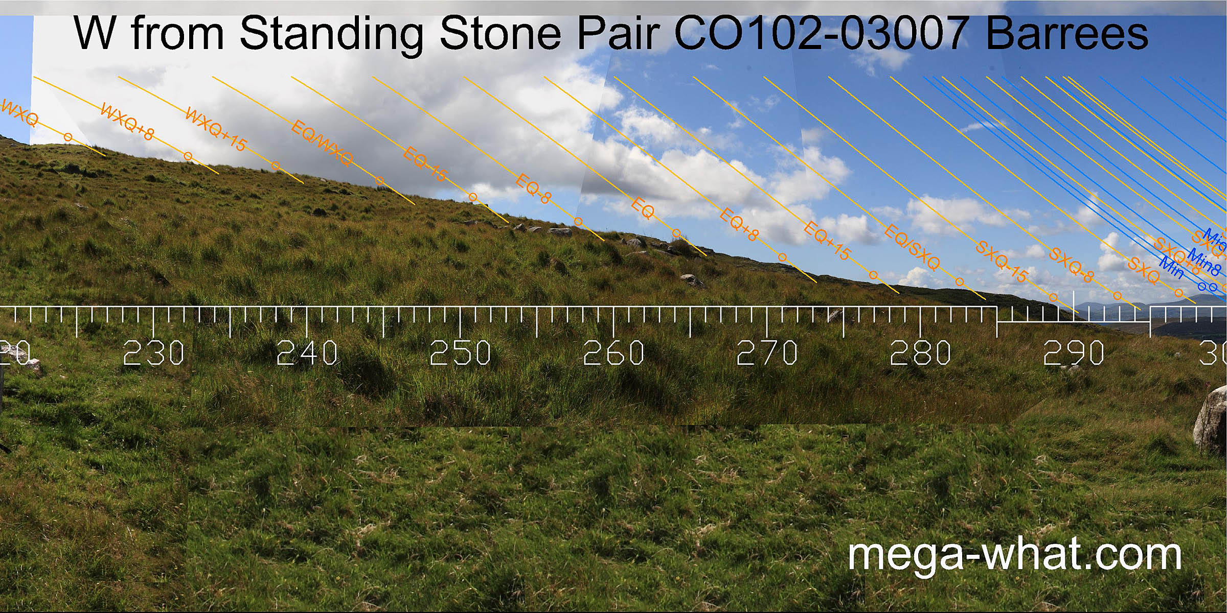
 To the south-west, the pair axis indicates the direction of a half-month off the cross quarter and the minor end of the lunistice cycle.
The southern hill makes a nice humpy-bumpy skyline and a useful measure for the winter part of the year and half the lunistice range.
The minor end of the cycle is particularly good as it coincides with a sloping and varied profile that stretches it out and gives the potential for considerable accuracy.
To the south-west, the pair axis indicates the direction of a half-month off the cross quarter and the minor end of the lunistice cycle.
The southern hill makes a nice humpy-bumpy skyline and a useful measure for the winter part of the year and half the lunistice range.
The minor end of the cycle is particularly good as it coincides with a sloping and varied profile that stretches it out and gives the potential for considerable accuracy.
 The western horizon is again a north facing slope but this time rather smooth and quite close but it does make up for some lack of utility to the east.
Notably, there is a good equinoctial mark and a serviceable winter cross-quarter one.
The western horizon is again a north facing slope but this time rather smooth and quite close but it does make up for some lack of utility to the east.
Notably, there is a good equinoctial mark and a serviceable winter cross-quarter one.
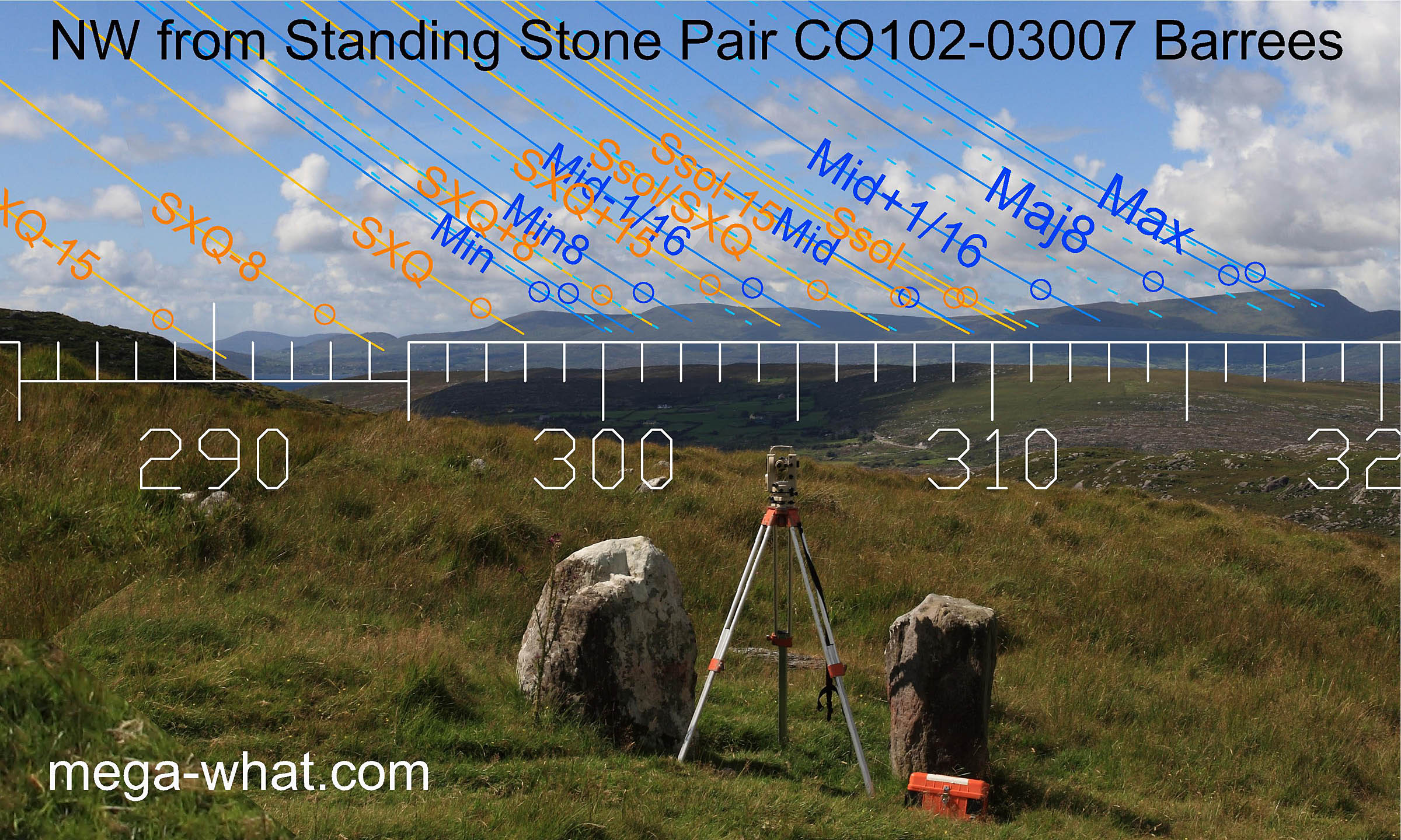 To the north-west, a distant horizon provides useful markers for the summer part of the year and also the northerly moonsets -
with the midpoint of the lunistice cycle falling predictably in the central dip.
To the north-west, a distant horizon provides useful markers for the summer part of the year and also the northerly moonsets -
with the midpoint of the lunistice cycle falling predictably in the central dip.
Excavation in 2003 found three small white quartz boulders beside the western stone and charcoal indicative of at least one fire was 14C dated to 2830±30 BP (GrN-28306). Beside the stone-lined socket of the fallen eastern stone, a small pit containing cremated bone and charcoal was sealed by some white quartz pebbles topped with a small slab. A second deposit of cremated bone and charcoal was also found beside this socket. A number of nearby hutsites were examined and one, found to be a substantial building (6.7m x 5.2m), had charcoal from its hearth dated to 2465±20 BP (GrN-28302).
For similar use of a high southern horizon see Cashelkeelty, about 8km to the east.
References
- Archaeological Survey of Ireland, record details. www.archaeology.ie/archaeological-survey-ireland
- POWER, D. et al. 1992 Archaeological Inventory of County Cork, Volume 1: West Cork. Dublin: Stationary Office. p401, no.3575c.
- O'BRIEN, WILLIAM 2003 Cork 2003:0174 Barrees. www.excavations.ie