 This stone circle at Uragh is beside the river Ameen and visible across it from the public road.
Badly damaged with only two upright stones and a broken stump remaining in situ. These are almost certainly the east portal, east sidestone and axial stone of a five stone circle.
South is on the left slope of a hill [Pic].
North is at the right end of the highest hilltop [Pic].

 The north-eastern horizon is very local and the circle axis indicates the major end of the lunisticeLunistices are the most northerly and southerly moons of the month. The lunar equivalent of solstices - more.
range. Major standstillsLunistice positions vary cyclically over an 18.6 year period but are fairly static for more than a year at either end of the range
are marked by a top/dip, solstices by a dip/top.
Minor standstillsLunistice positions vary cyclically over an 18.6 year period but are fairly static for more than a year at either end of the range
are half-way up a slope that is a quarter-month south of summer cross-quarters at the bottom and lunar minor eighth at the top.
 The east is also local and position sensitive. Winter cross-quarters and the equinox are on tops. Summer cross-quarters are half-way up a slope that is about a half-month long. Everything fits nicely.
 To the south-east, winter cross-quarters rise from a top, the north base of which is a half-month on the summer side. The south base is a critical lunar marker with a swell of the slope indicating the solstice and the solstice / cross-quarter midpoint at a step
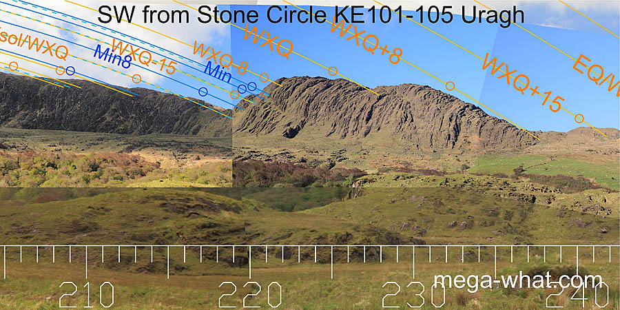
 The south-western slopes offer considerable precision for many events, with winter cross-quarters being the most obvious.
 The west is obscured but the equinox is close to the intersect of near and far. Summer cross-quarters are in the last dip of the far horizon, winter ones in a hilltop dip.
Many other events are indicated by changes of slope.
The circle axis indicates the winter cross-quarter / equinox midpoint [Pic].
 The north-west is a rising slope. Minor standstillsLunistice positions vary cyclically over an 18.6 year period but are fairly static for more than a year at either end of the range
are at the last distant top/step, major ones at a nearer one. What happens in between is uncertain.
This is probably the most recent sacred site in the area. The five stone circle people would have built their first monument beside an existing standing stone on arrival and then, after further clearance, created this one to be uniquely their own.
- Cooryeen Boulder-Burials are c.260m east (99°) across the river
- Uragh Five Stone Circle is c.500m south-west (237°)
- Uragh Multiple Stone Circle & Boulder-Burials are c.1.2km south-west (236°)
References
- Archaeological Survey of Ireland, record details. www.archaeology.ie/archaeological-survey-ireland
- BYRNE, ELIZABETH et al. 2009 Archaeological Inventory of County Kerry, Volume I: South-West Kerry. Dublin: Stationary Office. p20, no.77.
