
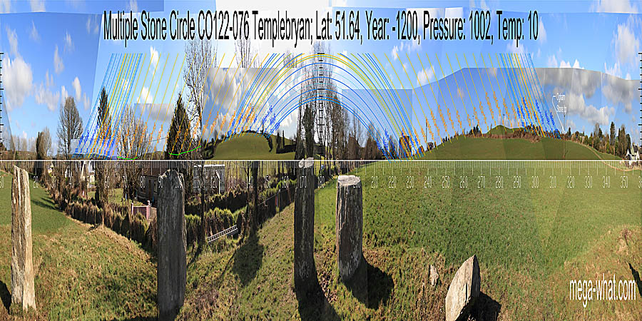
 The Stone Circle at Templebryan North is about 2.5km north of Clonakilty and is the eastmost circle of a local group.
Six stones remain. Two have been regarded as possibly being the axial and a portal. If they are then the circle axis is substantially more extreme than usual.
This may have been a convention for indicating superiority of the SE/NW horizons to the normally preferred NE/SW ones. Green lines approximate hidden horizons.
The Stone Circle at Templebryan North is about 2.5km north of Clonakilty and is the eastmost circle of a local group.
Six stones remain. Two have been regarded as possibly being the axial and a portal. If they are then the circle axis is substantially more extreme than usual.
This may have been a convention for indicating superiority of the SE/NW horizons to the normally preferred NE/SW ones. Green lines approximate hidden horizons.
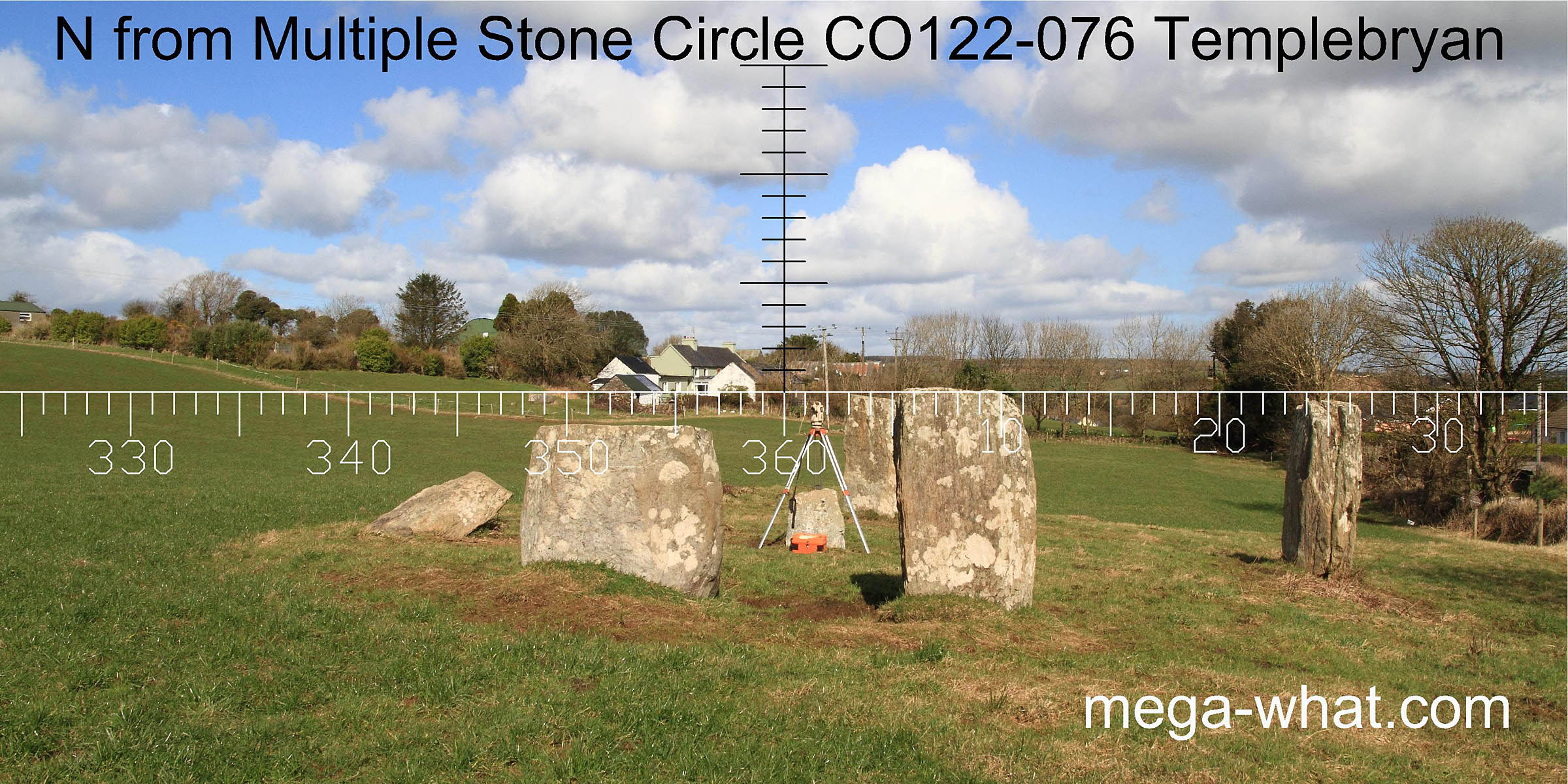 The internal monolith indicates north/south. North is at or near the intersect of near and far horizons but obscured.
The circle axis is perhaps 10° clockwise of it [Pic]
The internal monolith indicates north/south. North is at or near the intersect of near and far horizons but obscured.
The circle axis is perhaps 10° clockwise of it [Pic]
![[Pic]](Templebryan-NEax.jpg)
South is on a slope on the left side of a dip [Pic] The circle axis is perhaps 10° clockwise of it [Pic]
![[Pic]](Templebryan-S.jpg)
![[Pic]](Templebryan-SWax.jpg)
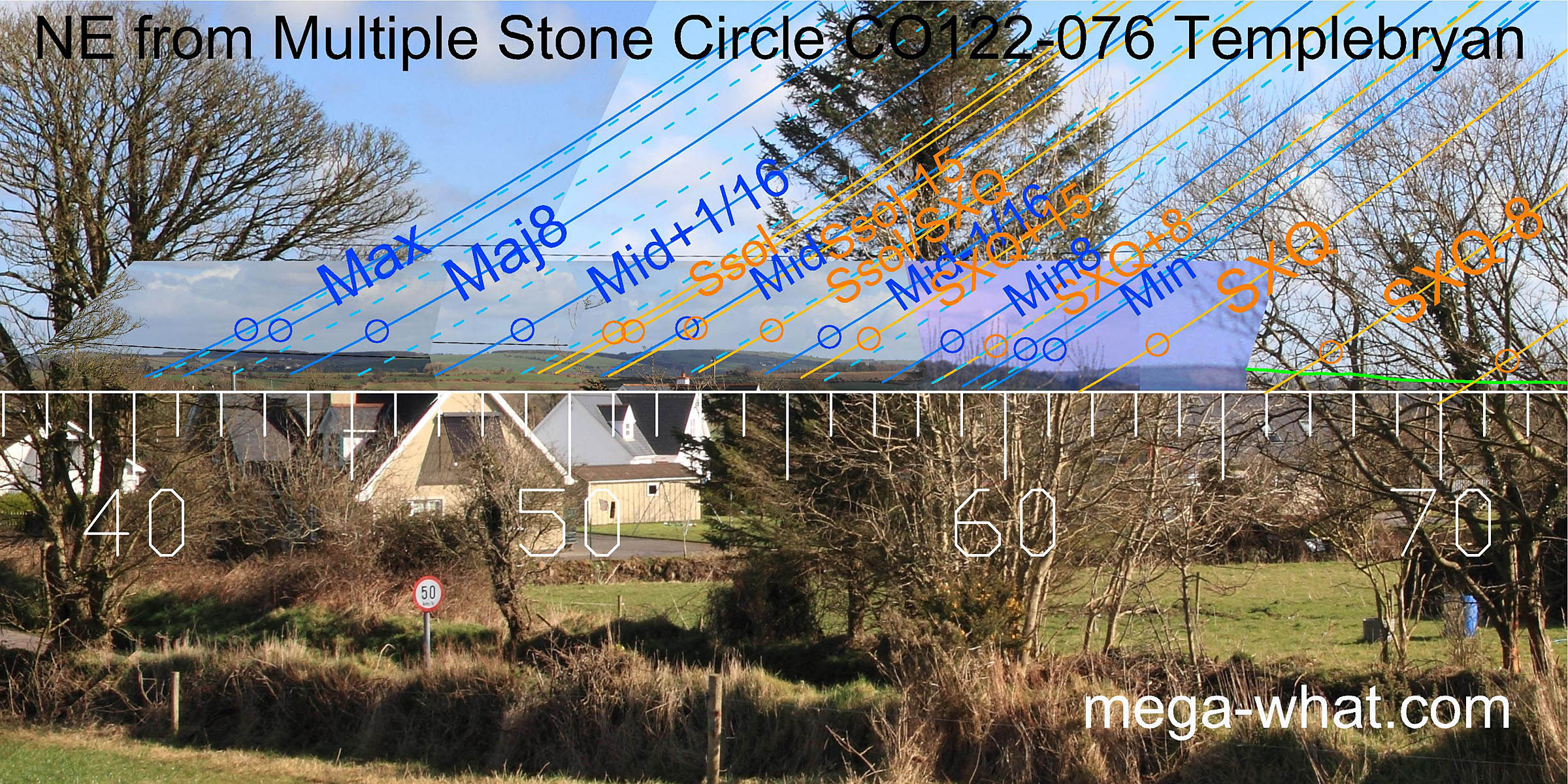 To the north-east, the major standstillLunistice positions vary cyclically over an 18.6 year period but are fairly static for more than a year at either end of the range
of the moon is marked by a slight dip while the minor standstillLunistice positions vary cyclically over an 18.6 year period but are fairly static for more than a year at either end of the range
is at a fairly significant intersect.
Between them, most of the important points fall at dips or breaks but the solstice and the solstice/ cross-quarter midpoint are marked by hilltops.
To the north-east, the major standstillLunistice positions vary cyclically over an 18.6 year period but are fairly static for more than a year at either end of the range
of the moon is marked by a slight dip while the minor standstillLunistice positions vary cyclically over an 18.6 year period but are fairly static for more than a year at either end of the range
is at a fairly significant intersect.
Between them, most of the important points fall at dips or breaks but the solstice and the solstice/ cross-quarter midpoint are marked by hilltops.
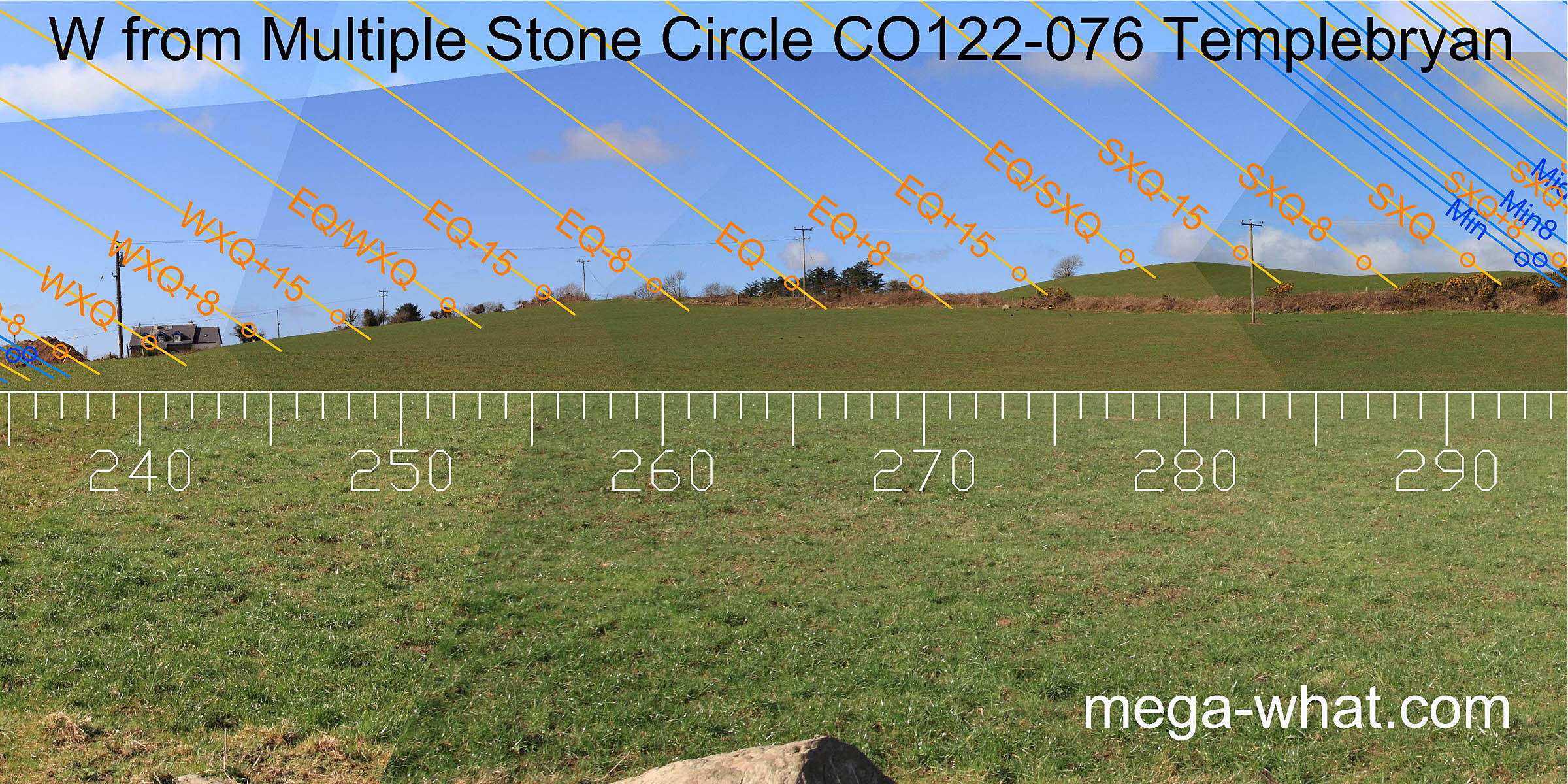
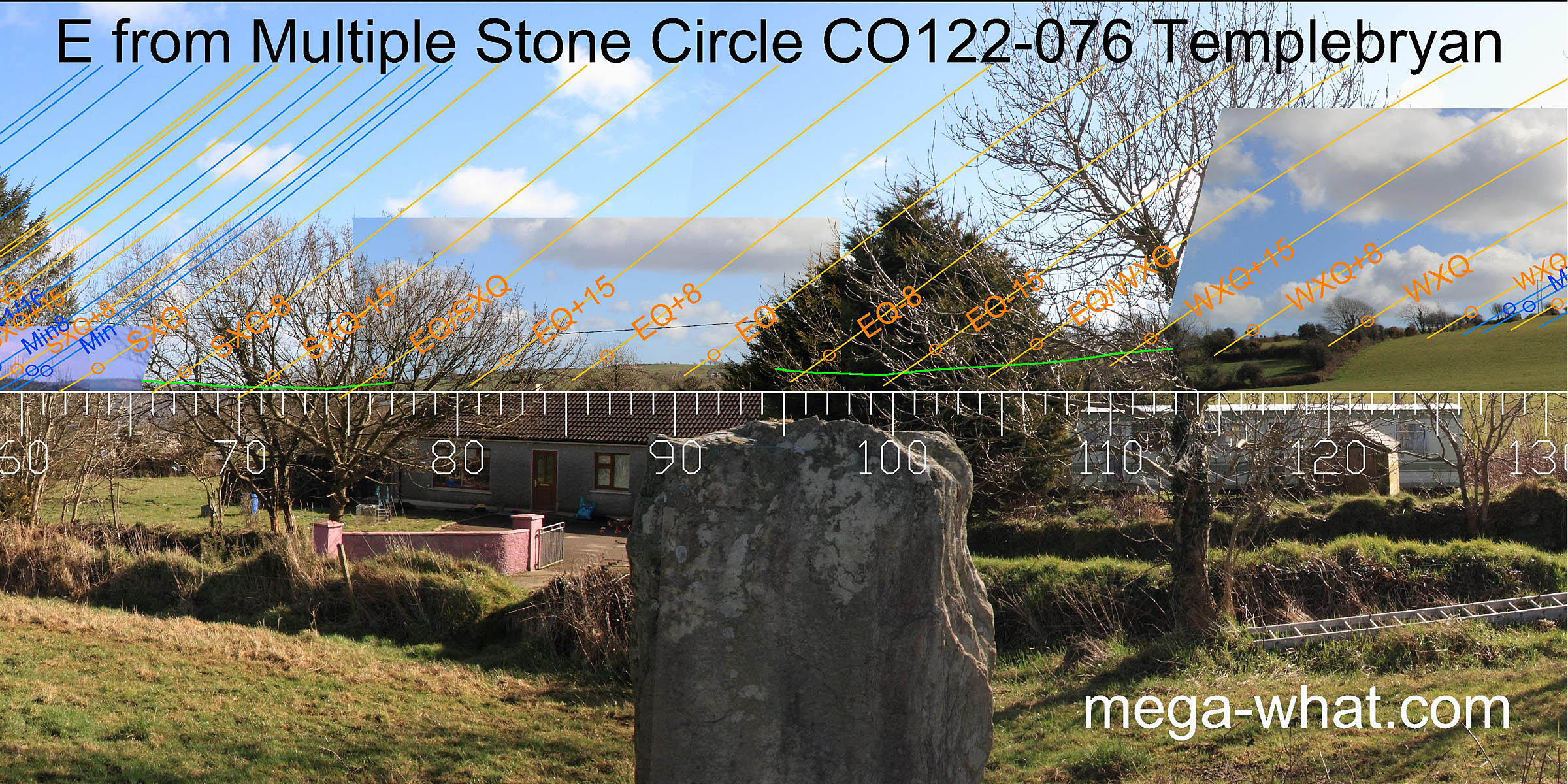 The eastern horizon is rather obscured by vegetation, both local and distant. A rounded hilltop is equinoctial.
Its north-east intersect, slightly obscured by vegetation, is close to being the equinox/ summer cross-quarter midpoint.
The south-east intersect, also obscured, looks to be about two weeks before spring equinox.
The eastern horizon is rather obscured by vegetation, both local and distant. A rounded hilltop is equinoctial.
Its north-east intersect, slightly obscured by vegetation, is close to being the equinox/ summer cross-quarter midpoint.
The south-east intersect, also obscured, looks to be about two weeks before spring equinox.
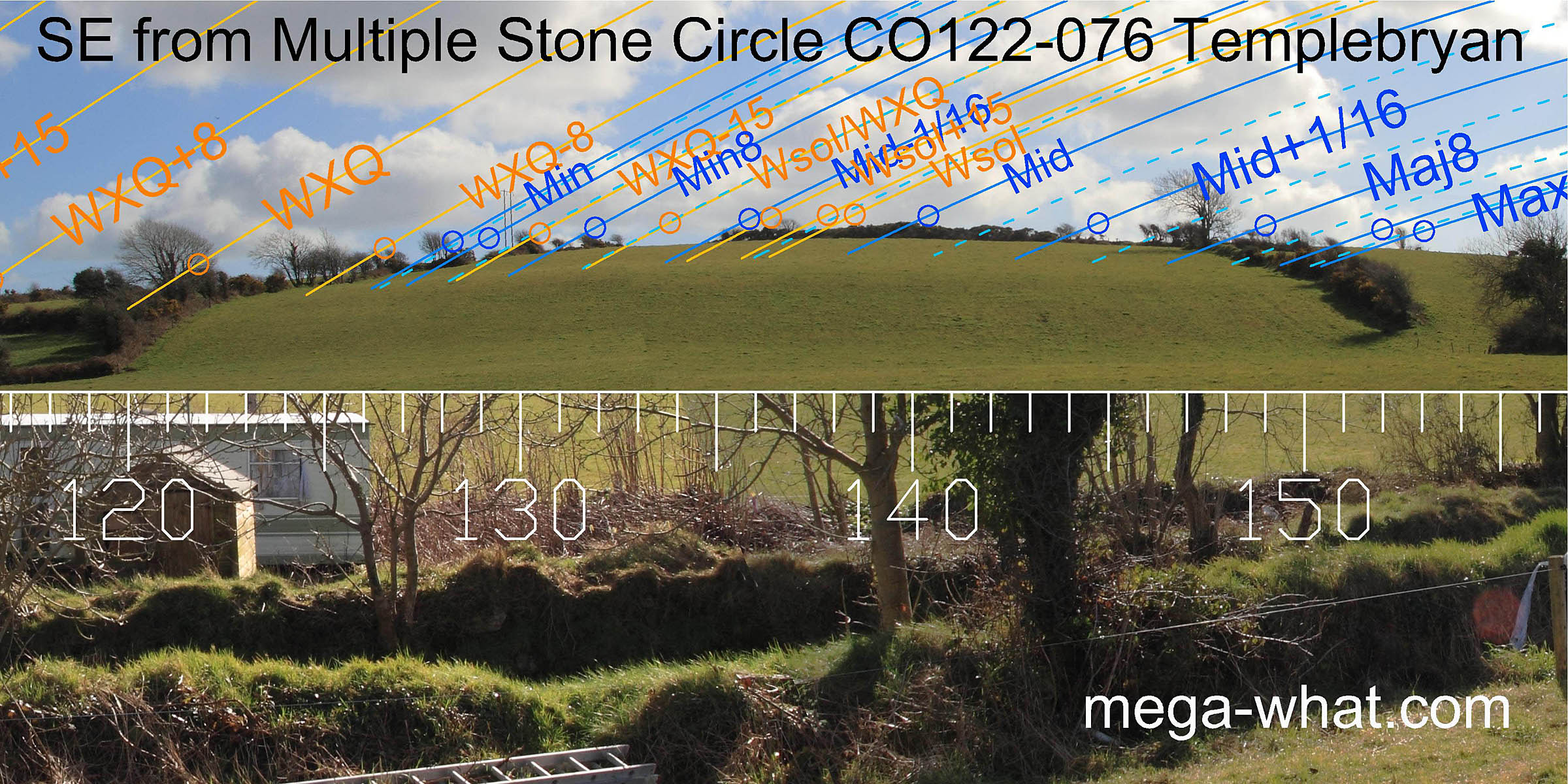 A nearby hill dominates the south-eastern horizon. The lunisticeLunistices are the most northerly and southerly moons of the month. The lunar equivalent of solstices - more.
range straddles the rather broad hilltop which is also effectively the winter solstice sunrise point.
A nearby hill dominates the south-eastern horizon. The lunisticeLunistices are the most northerly and southerly moons of the month. The lunar equivalent of solstices - more.
range straddles the rather broad hilltop which is also effectively the winter solstice sunrise point.
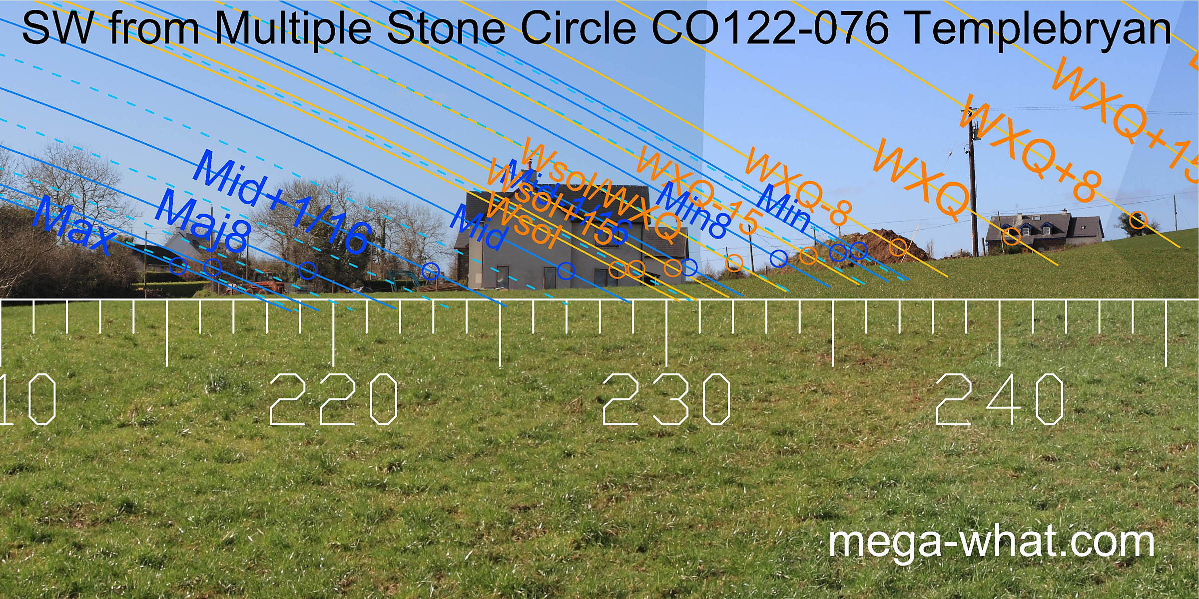 North of the supposed axial stone, the intersection of nearer south-facing slope and more distant north-facing one is now irretrievably obscured by houses and a road.
It seems likely that it once marked major standstillLunistice positions vary cyclically over an 18.6 year period but are fairly static for more than a year at either end of the range
moonsets.
North of the supposed axial stone, the intersection of nearer south-facing slope and more distant north-facing one is now irretrievably obscured by houses and a road.
It seems likely that it once marked major standstillLunistice positions vary cyclically over an 18.6 year period but are fairly static for more than a year at either end of the range
moonsets.
 Winter cross-quarters are at a break in the upslope. The equinox is in the middle of a flat section that is about three weeks wide.
A break just before the hilltop is midway to / from the summer cross-quarter, which itself is at another break.
Winter cross-quarters are at a break in the upslope. The equinox is in the middle of a flat section that is about three weeks wide.
A break just before the hilltop is midway to / from the summer cross-quarter, which itself is at another break.
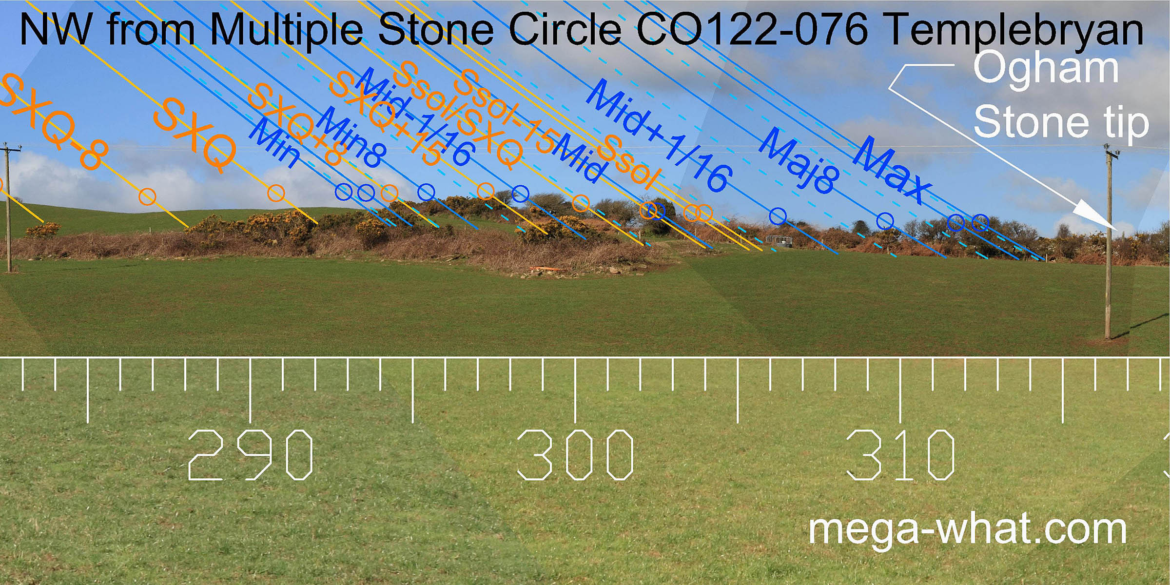 North-westwards, the summer cross-quarter and lunar minor standstil are either side of a minor high point that marks the top of a slope.
Vegetation obscures detail of horizon but the tip of a nearby Ogham Stone (CO122-075004) is just visible.
North-westwards, the summer cross-quarter and lunar minor standstil are either side of a minor high point that marks the top of a slope.
Vegetation obscures detail of horizon but the tip of a nearby Ogham Stone (CO122-075004) is just visible.
- Ballyvackey Stone Circle is 4.6km west (256°)
- Knocks Boulder-Burials are about 6.4km to the north-west.
References
- Archaeological Survey of Ireland, record details. www.archaeology.ie/archaeological-survey-ireland
- BARBER, JOHN 1973 The Orientation of the recumbent-stone circles of the South-West of Ireland. Journal of the Kerry Historical and Archaeological Society 6:26-39, no.C19.
- Ó'NUALLÁIN, SEÁN 1975 The Stone Circle Complex of Cork and Kerry. Journal of the Royal Society of Antiquaries of Ireland 105:83-131, no.45.
- Ó'NUALLÁIN, SEÁN 1984 A Survey of Stone Circles in Cork and Kerry. Proceedings of the Royal Irish Academy 84c:1-77, p22, no.31.
- POWER, D. et al. 1992 Archaeological Inventory of County Cork, Volume 1: West Cork. Dublin: Stationary Office. p23, no.62.
- RUGGLES, C.L.N. 1999 Astronomy in Prehistoric Britain and Ireland. Newhaven & London: Yale University Press. No.ASC45.