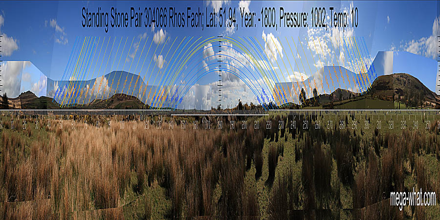
 Overall form is approximate symmetry around south which is in a wide dip.
To both sides: The south lunistice zone runs up a slope.
The central solar sequence spans a block of high ground
and then the northern lunistice zone runs up a slope to terminate at the top of a slope at the edge of a hill.
More specifically, south is at the left side of a dip, on the last hill of the south-eastern ridge
before its intersect with the western slope and is indicated by the axis of the smaller stone.
North is at the left side of a dip, at the foot of the tallest hill.

Vertical scale x4, maxpic 3200x1600.
Orange lines mark the annual solar round. Lunistice positions over the 18.6 year lunar nodal cycle are blue. More about the Solar Calendar More about the Lunar Calendar More about this placeLook North
Rhos Fach Stone Pair: 360° S centred
 Overall form is approximate symmetry around south which is in a wide dip.
To both sides: The south lunistice zone runs up a slope.
The central solar sequence spans a block of high ground
and then the northern lunistice zone runs up a slope to terminate at the top of a slope at the edge of a hill.
More specifically, south is at the left side of a dip, on the last hill of the south-eastern ridge
before its intersect with the western slope and is indicated by the axis of the smaller stone.
North is at the left side of a dip, at the foot of the tallest hill.
- Gors Fawr Standing Stone Pair is 1km south.
- Cwm Garw Standing Stone Pair is 1.6km to the west-north-west.
| Home | Site Lists | Glossary | Survey Data |
Most archaeological monuments are on private property and where not otherwise indicated those wishing to visit a site should seek permission from the landowner.