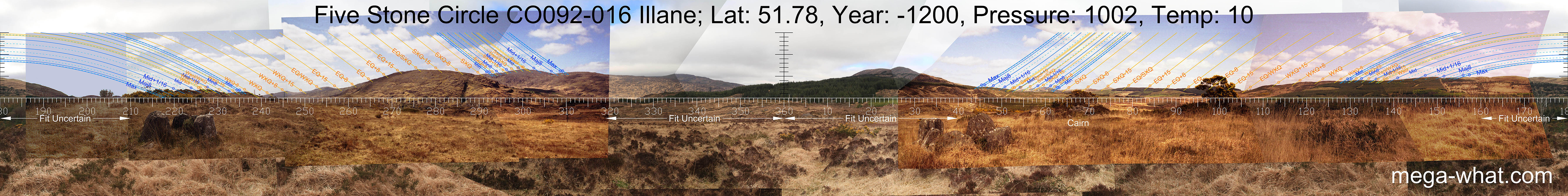
 North is on a slope, a bit to the right of a dip bottom. South is on a hump at the end of a ridge and to the left of a dip. The lunistice ranges span particularly useful segments of the horizon.
To the west, summer solstice sunset is on the highest top and summer cross-quarter / solstice midpoint is on the second highest top.
To the east, winter cross-quarter / solstice midpoint is in a significant dip and winter solstice sunrise is also in a dip.
North is on a slope, a bit to the right of a dip bottom. South is on a hump at the end of a ridge and to the left of a dip. The lunistice ranges span particularly useful segments of the horizon.
To the west, summer solstice sunset is on the highest top and summer cross-quarter / solstice midpoint is on the second highest top.
To the east, winter cross-quarter / solstice midpoint is in a significant dip and winter solstice sunrise is also in a dip.

Vertical scale x4, maxpic 3200x1600.
Orange lines mark the annual solar round. Lunistice positions over the 18.6 year lunar nodal cycle are blue. More about the Solar Calendar More about the Lunar Calendar More about this placeLook South
Illane Stone Circle: 360° N centred
North is on a slope, a bit to the right of a dip bottom. South is on a hump at the end of a ridge and to the left of a dip. The lunistice ranges span particularly useful segments of the horizon.
To the west, summer solstice sunset is on the highest top and summer cross-quarter / solstice midpoint is on the second highest top.
To the east, winter cross-quarter / solstice midpoint is in a significant dip and winter solstice sunrise is also in a dip.
- Maughanasilly Stone Row is 1km south (190°)
- Kealkill Five Stone Circle, Stone Pair & Cairn are 4km south (167°)
- Mill Little Five Stone Circle, Boulder-Burials & Stone Pair are 6.5km west (278°)
| Home | Site Lists | Glossary | Survey Data |
Most archaeological monuments are on private property and where not otherwise indicated those wishing to visit a site should seek permission from the landowner.