
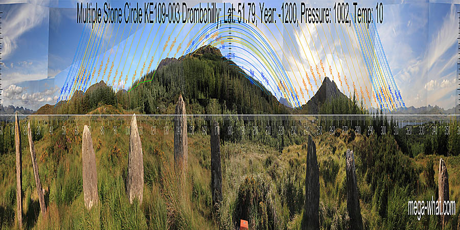
 Drombohilly Stone Circle is about 2km south of Tuosist, 2.5km north of Lauragh. A few hundred metres from the road, without a path and surrounded by recent forestry.
Nine upright stones remain of a probable eleven.
Drombohilly Stone Circle is about 2km south of Tuosist, 2.5km north of Lauragh. A few hundred metres from the road, without a path and surrounded by recent forestry.
Nine upright stones remain of a probable eleven.
South is on a slope to the right of a hilltop. Perhaps on a slight rise but detail is obscured by forestry [Pic].
![[Pic]](DrombohillyMSC-S.jpg)
North is on a distant hilltop, at the left side of a block of high ground [Pic].
![[Pic]](DrombohillyMSC-N.jpg)
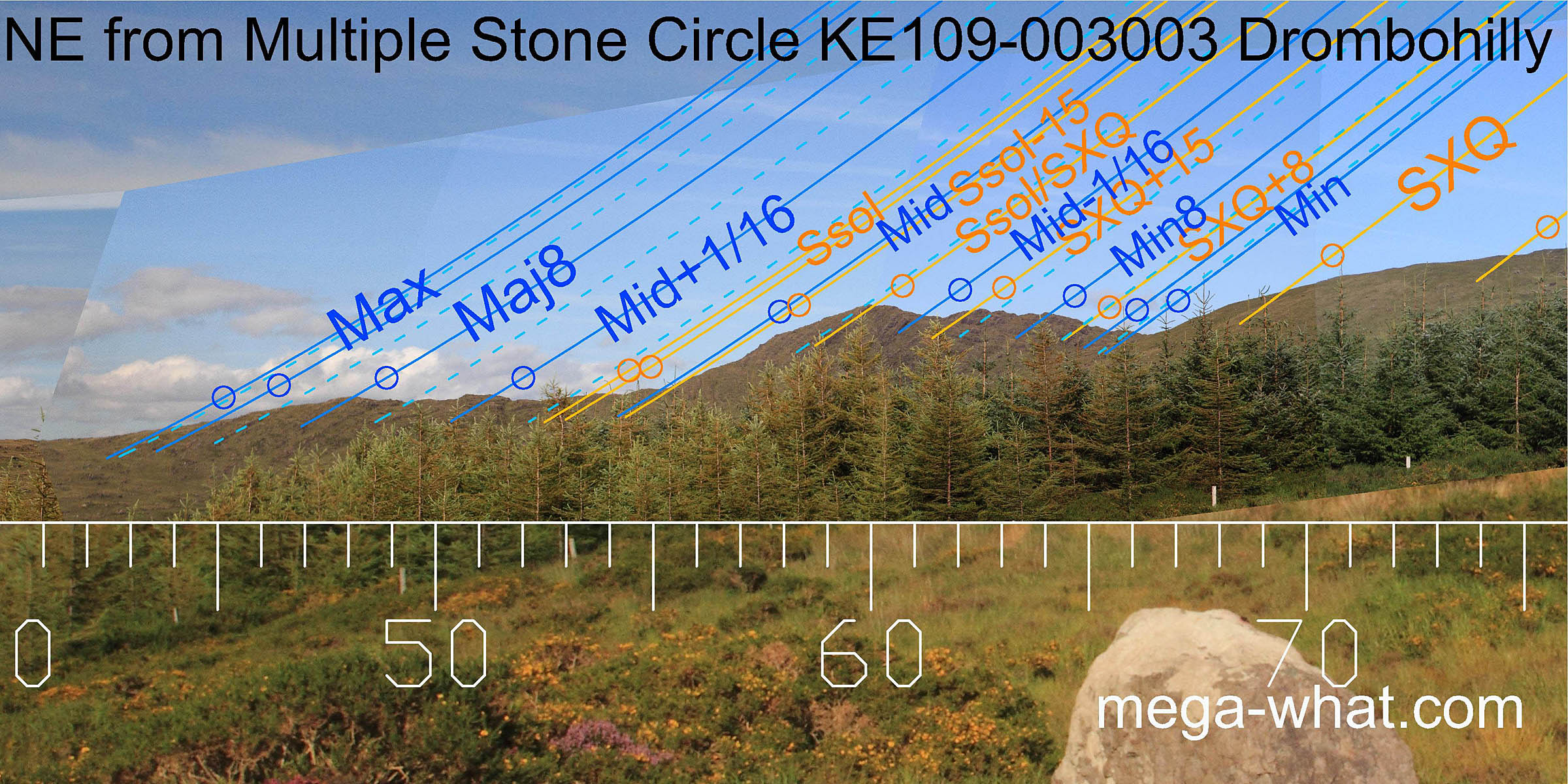 The north-eastern lunisticeLunistices are the most northerly and southerly moons of the month. The lunar equivalent of solstices - more.
range starts with minor standstillLunistice positions vary cyclically over an 18.6 year period but are fairly static for more than a year at either end of the range
in a dip and ends with major standstillLunistice positions vary cyclically over an 18.6 year period but are fairly static for more than a year at either end of the range
in another though not quite at the bottom.
The north-eastern lunisticeLunistices are the most northerly and southerly moons of the month. The lunar equivalent of solstices - more.
range starts with minor standstillLunistice positions vary cyclically over an 18.6 year period but are fairly static for more than a year at either end of the range
in a dip and ends with major standstillLunistice positions vary cyclically over an 18.6 year period but are fairly static for more than a year at either end of the range
in another though not quite at the bottom.
The hilltop in the middle is half-way between summer cross-quarters and the solstice.
The circle axis is well beyond all of it [Pic]
![[Pic]](DrombohillyMSC-NEax.jpg)
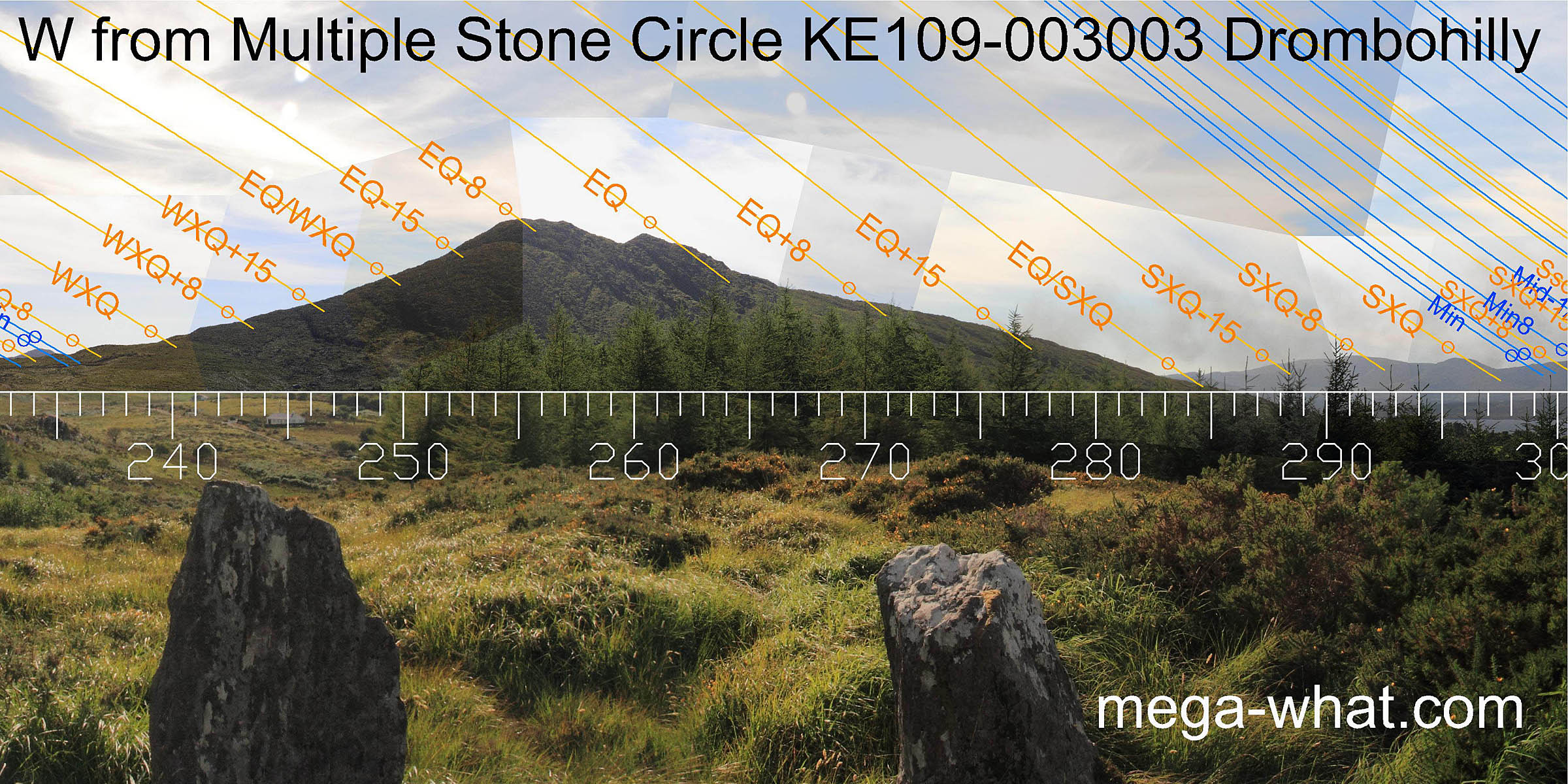
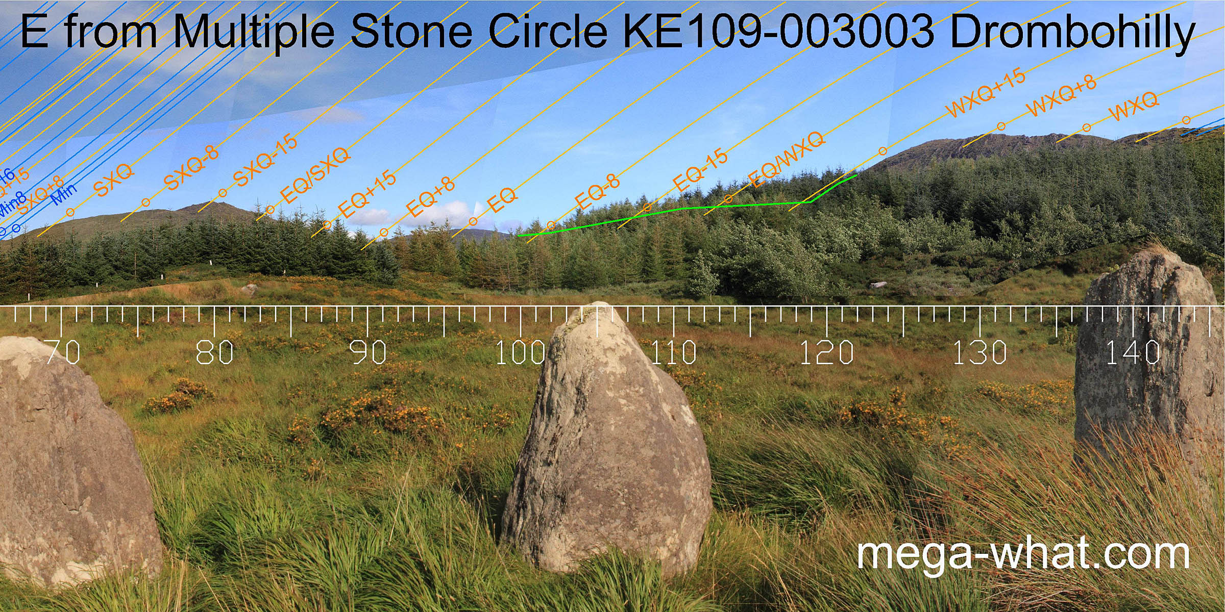 The east is rapidly disappearing behind the growing trees but the equinox is on a hilltop.
Eight & fifteen day markers for the cross-quarters are also well marked.
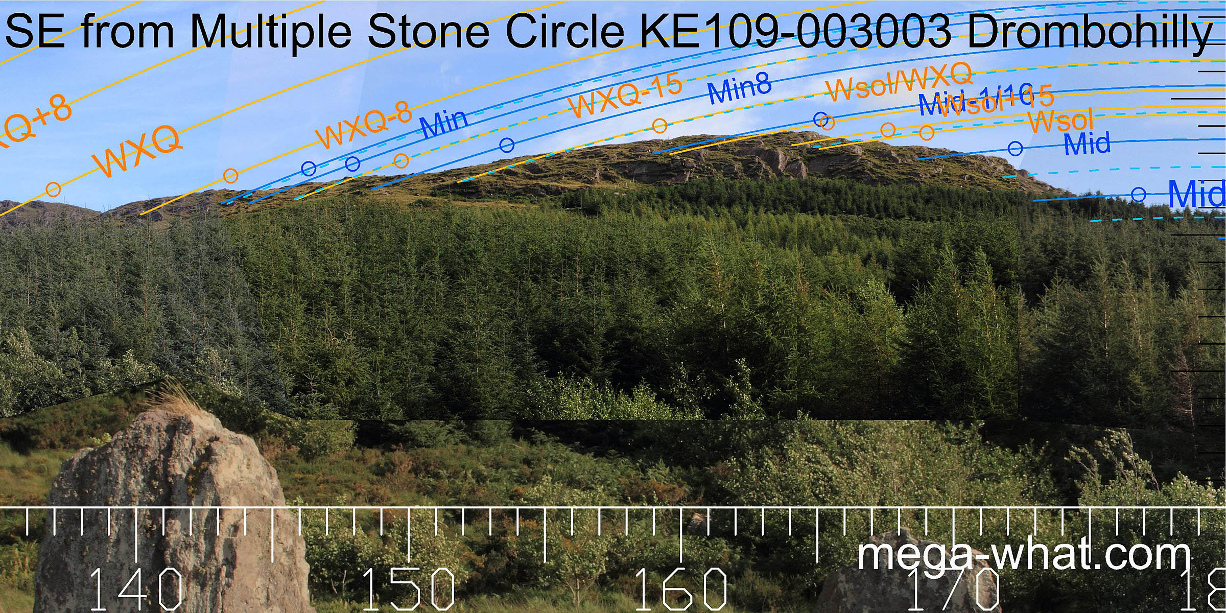 A local rocky hill to the south-east makes useful markers for winter sunrises and the minor half of the lunisticeLunistices are the most northerly and southerly moons of the month. The lunar equivalent of solstices - more.
range.
A local rocky hill to the south-east makes useful markers for winter sunrises and the minor half of the lunisticeLunistices are the most northerly and southerly moons of the month. The lunar equivalent of solstices - more.
range.
The top marks the limits of a month centred on winter solstice.
South is on the western slope but forestry has obscured the profile [Pic].
 The circle axis indicates the major end of the lunisticeLunistices are the most northerly and southerly moons of the month. The lunar equivalent of solstices - more.
range and there was probably considerable precision to be had there when the ridge was bare.
The circle axis indicates the major end of the lunisticeLunistices are the most northerly and southerly moons of the month. The lunar equivalent of solstices - more.
range and there was probably considerable precision to be had there when the ridge was bare.
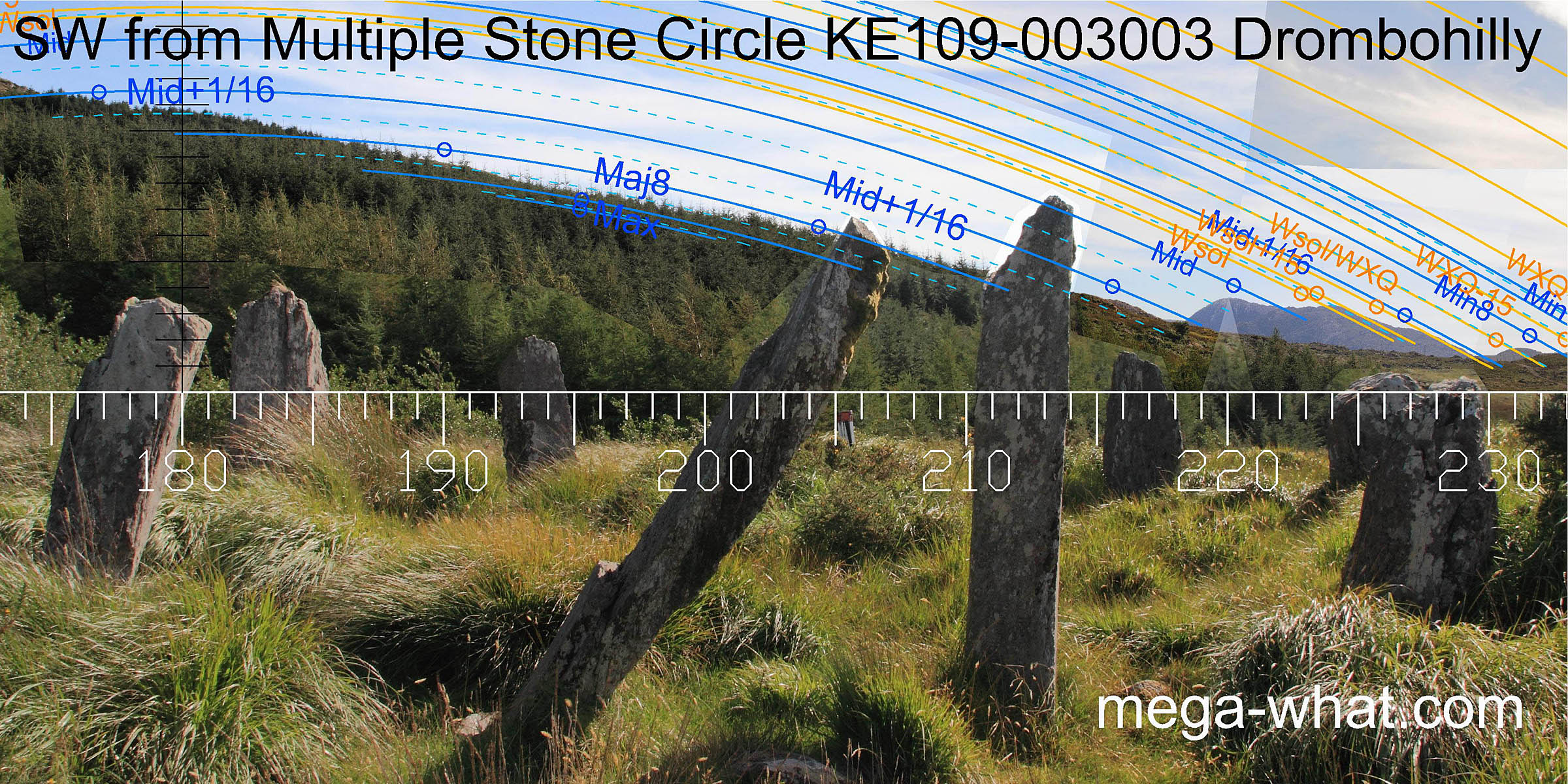
The far south-west provides many good markers, with the lunar points all in dips and winter solstice on a hilltop.
 A large hill to the west has the one week early warning for spring equinox on its main peak and the equinox on the other.
Winter cross-quarters are at the southern basal step.
The northern basal dip is half-way to the summer cross-quarters which are themselves marked by a distant low hilltop.
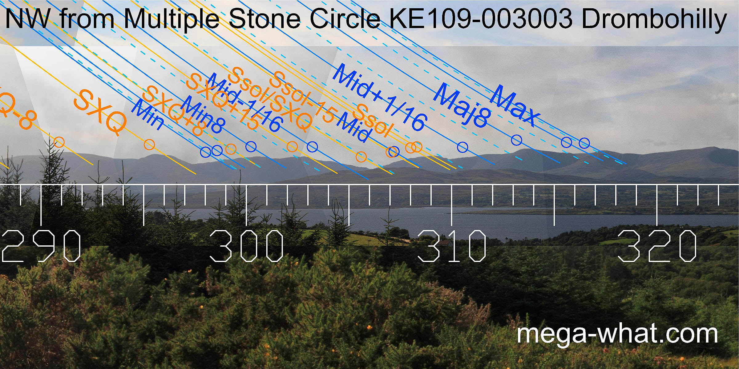 After the summer cross-quarters hillop, summer solstice sunset is on another top with the half-way point betwen them in a dip.
The lunar eighths and major standstillLunistice positions vary cyclically over an 18.6 year period but are fairly static for more than a year at either end of the range are marked by hilltops.
Within the local monument group (but not surveyed):
- Wedge Tomb KE109-022, c.300m up the hill would have been earlier but is now unsurveyably inside the forestry plantation.
- Lehid Boulder-burials c.600m to the SW and close to the road are almost certainly a bit later.
- Lehid Standing Stone c.600m to the SW and close to the road is possibly the latest ritual monument of this local group.
- In the general same area there are also the remains of a number of hut sites, enclosures and field systems.
- Cashelkeelty Stone Circles & Stone Row are c.6km south-west.
- Shronebirrane Stone Circle is c.7km south-south-west.
- Uragh Five Stone Circle is one of a local group of monuments c.5km north-east (56°)
References
- Archaeological Survey of Ireland, record details. www.archaeology.ie/archaeological-survey-ireland
- BYRNE, ELIZABETH, et.al. 2009 Archaeological Inventory of County Kerry. Volume I: South-West Kerry. Dublin: Stationery Office. p15, no.61.
- Ó'NUALLÁIN, SEÁN 1984 A Survey of Stone Circles in Cork and Kerry. Proceedings of the Royal Irish Academy 84c:1-77, p30, no.48.
- RUGGLES, C.L.N. 1999 Astronomy in Prehistoric Britain and Ireland. Newhaven & London: Yale University Press. No.ASC28.