
 Derreennaclogh Rock Art is between Bantry and Ballydehob but is on private property and not open to the public.
It is at the top of the Bawnaknockane River, only 5km from its outlet into Ballydehob Bay. There is an excellent view down the valley towards Mount Gabriel.
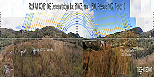 South is on the right hand top of a hill that is on the left side of the lowest dip [Pic].
To both sides of the southern hill/dip sequence the land rises to a highpoint, falls to a dip and rises to another top.
There follows one more dip before a hilltop that is just right of due North [Pic].
South is on the right hand top of a hill that is on the left side of the lowest dip [Pic].
To both sides of the southern hill/dip sequence the land rises to a highpoint, falls to a dip and rises to another top.
There follows one more dip before a hilltop that is just right of due North [Pic].
![[Pic].](Derreennaclogh-S.jpg)
![[Pic].](Derreennaclogh-N.jpg)
Default date for trajectories is the early bronze age one of 1800BCE but earlier and later alternatives are given for comparative purposes [1]
| SW c.3000BC | SW c.800BC |

Winter solstice sunset is at the south basal notch. Its half-month bracket is at the next notch and the top of the south slope is half-way to the cross-quarters. The summit is a half-month from the cross-quarters, which are at the next hilltop with the quarter-month at the bottom of the dip between them.
The lunisticeLunistices are the most northerly and southerly moons of the month. The lunar equivalent of solstices - more. cycle is also easily measurable on this horizon sector, with the minor end gaining extra precision by falling on a north facing slope.
Mt Gabriel is about 9km away so this is the only horizon sector where date could have a bigger impact than observer position.
| W c.3000BC | W c.800BC |

The western horizon is much more local and the profile disguised by forestry. Differences due to changes in obliquity are small in this central zone.
A prehistoric copper mine (CO131-020 Derrycarhoon) is just the other side of the western ridge. It was worked in medieval and more recent times but finds of Mt. Gabriel type stone mauls imply an early bronze age date for the original workings (O'Brien, 1989).
| NW c.3000BC | NW c.800BC |

Much of the north-west is obscured by forestry but the part that can be seen does seem to offer some utility.
| NE c.3000BC | NE c.800BC |

The north-east is also compromised by trees but summer cross-quarters are at the foot of the slope and the major standstillLunistice positions vary cyclically over an 18.6 year period but are fairly static for more than a year at either end of the range of the moon is at the top of it.
| E c.3000BC | E c.800BC |

Eastwards, a hilltop dip is accurately half-way between equinox and winter cross-quarter. Differences due to changes in obliquity are smallest in this central zone.
On the other side of this ridge (2.3km, 130°) are two more rock art sites of similar type at Ballybane West. CO131-039 is a National Monument but a smaller slab c.80m from it, known as the Rock of the Rings [CO131-040] is not.
| SE c.3000BC | SE c.800BC |

Rock outcrops help give some useful texture to the part of the south-eastern slope occupied by the lunisticeLunistices are the most northerly and southerly moons of the month. The lunar equivalent of solstices - more. range and winter sunrises.
Bear in mind that all of the horizon except the south-west is fairly local and thus easily influenced by changes in observer position. For more on the rock art itself see: Pictures by Robert Harris.
The nearest megalithic monuments are:
- Standing stones CO131-051 Cappagh More (3.7km, 115°)
- Short stone row CO140-019 Murrahin North (4.7km, 140°)
- Standing stone CO140-004 Rathruane Beg (4.8km, 232°)
- Boulder-burial CO140-057 Rathruane More (5.2km, 224°)
- Cairn CO131-048 Letterlicky is closer (2.5km, 31°) but not visible from here.
Notes
- This was the first rock art site to be surveyed and, because dates for rock art are both uncertain and debated, three alternative sets of trajectories were calculated. They are given here for illustrative purposes, even though the early bronze age default value of c.1800BCE is a reasonable fit and the differences are not great. It is more likely that this rock art is earlier rather than later than that but 800BCE marks the end of the bronze age while 3000BCE is neolithic. Please do remember Hawkins' (1973,288) Criteria 1: "Construction Dates Should Not Be Determined from Astronomical Alignments". The biggest changes occur at the major standstillLunistice positions vary cyclically over an 18.6 year period but are fairly static for more than a year at either end of the range positions and, over the given 2,200 year period, amount to about 1/2 degree of azimuth. A shift of this magnitude may also be obtained by moving about 9m sideways relative to a 1km horizon, 27m would do the same for a 3km horizon. Most of these horizons are in the 1-3km ballpark and so changes due to date are generally less significant than exact observer position.
References
- Archaeological Survey of Ireland, record details. www.archaeology.ie/archaeological-survey-ireland
- Archaeological Survey of Ireland, feature. monument-of-the-month/archive/derreennaclogh
- HAWKINS, GERALD S. 1973 Beyond Stonehenge. London: Hutchinson.
- O'BRIEN, W.F. 1989 A primitive mining complex at Derrycarhoon, Co. Cork. Journal of the Cork Historical and Archaeological Society 94:1-17.
- FINLAY, F. & HARRIS, R. 2017 Rock Art at Derreennaclogh, Co Cork. Journal of the Skibbereen and District Historical Society 13 171-184. Available at www.academia.edu/34110074