
 Cappagh More Standing Stones are south of Mt Kid, between Bantry and Ballydehob.
They are officially listed as a Standing Stone and Possible Standing Stone, with the latter lying flat on the ground.
In 2002 a retired farmer, who had lived there all his life, told me that in his youth there were people who could remember both stones standing.
They are about 30m apart and of similar size and shape. Being tall, wide and thin, each would have been a good pointer in its own right.
Thus they may be seen as an Anomalous Standing Stone Pair.
Cappagh More Standing Stones are south of Mt Kid, between Bantry and Ballydehob.
They are officially listed as a Standing Stone and Possible Standing Stone, with the latter lying flat on the ground.
In 2002 a retired farmer, who had lived there all his life, told me that in his youth there were people who could remember both stones standing.
They are about 30m apart and of similar size and shape. Being tall, wide and thin, each would have been a good pointer in its own right.
Thus they may be seen as an Anomalous Standing Stone Pair.

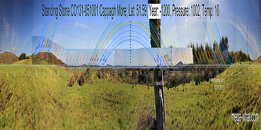
 The north-east axis of the upright stone is a bit beyond major standstillLunistice positions vary cyclically over an 18.6 year period but are fairly static for more than a year at either end of the range.
The lunisticeLunistices are the most northerly and southerly moons of the month. The lunar equivalent of solstices - more.
zone spans the top of the ridge with minor standstillLunistice positions vary cyclically over an 18.6 year period but are fairly static for more than a year at either end of the range
marked by a prominent V notch and summer solstice on the level top.
The north-east axis of the upright stone is a bit beyond major standstillLunistice positions vary cyclically over an 18.6 year period but are fairly static for more than a year at either end of the range.
The lunisticeLunistices are the most northerly and southerly moons of the month. The lunar equivalent of solstices - more.
zone spans the top of the ridge with minor standstillLunistice positions vary cyclically over an 18.6 year period but are fairly static for more than a year at either end of the range
marked by a prominent V notch and summer solstice on the level top.
 Eastwards, the equinox is in a V dip close to the intersect of near and far. Summer cross-quarters are in a notch at the top of the slope.
South of the equinox, the first non-distant hilltop is half-way to winter cross-quarter which is on the next one.
Eastwards, the equinox is in a V dip close to the intersect of near and far. Summer cross-quarters are in a notch at the top of the slope.
South of the equinox, the first non-distant hilltop is half-way to winter cross-quarter which is on the next one.

 To the south-east there is no significant difference between the two positions.
The lunisticeLunistices are the most northerly and southerly moons of the month. The lunar equivalent of solstices - more. zone is marked by a dip at the minor end and the major end is indicated by the sea and the stone's alignment. Knockonna hilltop is at the solstice / cross-quarter midpoint and the solstice is in a dip.

 There is no significant difference to the south-west either.
Summer solstice is at the sea / land intersect and the basal dip of Mt Gabriel is a quarter-month from the cross-quarter which is on the first hump.
The long axis of the upright stone is towards sea horizon and the major eighth. The fallen stone may have indicated the minor standstill
Lunistice positions vary cyclically over an 18.6 year period but are fairly static for more than a year at either end of the range hilltop.
There is no significant difference to the south-west either.
Summer solstice is at the sea / land intersect and the basal dip of Mt Gabriel is a quarter-month from the cross-quarter which is on the first hump.
The long axis of the upright stone is towards sea horizon and the major eighth. The fallen stone may have indicated the minor standstill
Lunistice positions vary cyclically over an 18.6 year period but are fairly static for more than a year at either end of the range hilltop.

 North of Mt Gabriel's south basal dip, the quarter-monthly divisions of the solar cycle are all well marked for as far as the original survey from the upper stone extended.
From the lower stone, the horizon is obscured beyond the equinox / cross-quarter midpoint.
North of Mt Gabriel's south basal dip, the quarter-monthly divisions of the solar cycle are all well marked for as far as the original survey from the upper stone extended.
From the lower stone, the horizon is obscured beyond the equinox / cross-quarter midpoint.
 From the lower stone, the north-west horizon is very local and the other stone would be silhouetted against the sky if upright.
From the upper stone the skyline is the often-used ridge that runs eastwards from Mt. Corrin but it has not been surveyed.
From the lower stone, the north-west horizon is very local and the other stone would be silhouetted against the sky if upright.
From the upper stone the skyline is the often-used ridge that runs eastwards from Mt. Corrin but it has not been surveyed.
This site is inter-visible with Foherlagh Stone Pair 4.1km to the south-east but neither site is on the horizon from the other.
Much closer at only 2km to the south is Murrahin Stone Row.
More anomalous Standing Stone Pairs of similar type may be found at Colomane East and at Glanbrack.
References
- Archaeological Survey of Ireland, record details. www.archaeology.ie/archaeological-survey-ireland
- POWER, D. et al. 1992 Archaeological Inventory of County Cork, Volume 1: West Cork. Dublin: Stationary Office. p48:no.267 & p67:no.510.