
 Drombeg stone circle is open to the public with some parking provided. It is also a National Monument (no.381).
Sometimes called the "Druid's Altar" and possibly the site of a sacrifice, it is near Glandore, the mythological home of "Cleena's Wave" (Tonn Cliodhna).
Cleena was a Danaan (fairy) maiden who had escaped from the land of youth (Tir na nÓg), with her mortal lover.
They came to shore in Glandore bay but while he went off hunting she, waiting on the beach, was lulled to sleep by fairy music and swept back to Tir na nÓg
on a magic wave sent by Mananan, the sea god. Thus Glandore becomes the "Strand of Cleena's Wave".
Drombeg stone circle is open to the public with some parking provided. It is also a National Monument (no.381).
Sometimes called the "Druid's Altar" and possibly the site of a sacrifice, it is near Glandore, the mythological home of "Cleena's Wave" (Tonn Cliodhna).
Cleena was a Danaan (fairy) maiden who had escaped from the land of youth (Tir na nÓg), with her mortal lover.
They came to shore in Glandore bay but while he went off hunting she, waiting on the beach, was lulled to sleep by fairy music and swept back to Tir na nÓg
on a magic wave sent by Mananan, the sea god. Thus Glandore becomes the "Strand of Cleena's Wave".
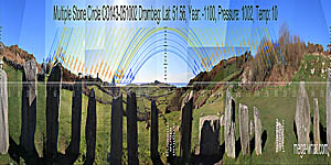 From the circle itself, due south is at a land / sea intersect on the eastern side of the lowest dip of the land.
This direction is indicated by the three stones to the left of the axial stone [Pic].
The tops of the outer two stones slope towards the middle one which was missing and has been replaced by a small boulder.
This particular arrangement is in strong contrast to that of the three stones to the right of the axial stone.
From the circle itself, due south is at a land / sea intersect on the eastern side of the lowest dip of the land.
This direction is indicated by the three stones to the left of the axial stone [Pic].
The tops of the outer two stones slope towards the middle one which was missing and has been replaced by a small boulder.
This particular arrangement is in strong contrast to that of the three stones to the right of the axial stone.
![[Pic].](Drombeg-S.jpg)
North is near a local high point but detail is obscured by vegetation [Pic].
![[Pic].](Drombeg-N.jpg)
 Drombeg stone circle is well known for its apparent winter solstice sunset alignment.
Those wishing to see it should be there by 3:45pm at the latest. This is a popular gathering and parking is likely to be difficult.
Drombeg stone circle is well known for its apparent winter solstice sunset alignment.
Those wishing to see it should be there by 3:45pm at the latest. This is a popular gathering and parking is likely to be difficult.
The prominent notch indicated by the circle's axis supposedly marks winter solstice sunset but this is not true. Not now, nor in the past, but it will be true in a couple of thousand years. This belief, perhaps started in1909SOMERVILLE, BOYLE T. 1909 Notes on a Stone Circle in County Cork. Journal of the Cork Historical and Archaeological Society 15:105-108. demonstrates the danger of having pre-conceived ideas about what the monument builders might find important and the level of accuracy they would be capable of.
 At construction time, from within the circle, the axial notch accurately marked the limits of a month centred on the solstice.
Thus the alignment actually defined the period within which the solstitial full moon must occur.
This solar date is doubly useful because its position is effectively the same as that of one of the lunar sixteenths.
Currently the sun sets in the notch about 10 days either side of the solstice.
At construction time, from within the circle, the axial notch accurately marked the limits of a month centred on the solstice.
Thus the alignment actually defined the period within which the solstitial full moon must occur.
This solar date is doubly useful because its position is effectively the same as that of one of the lunar sixteenths.
Currently the sun sets in the notch about 10 days either side of the solstice.
The south-western skyline has been fitted to both the lunisticeLunistices are the most northerly and southerly moons of the month. The lunar equivalent of solstices - more. cycle and the winter half of the solar cycle. Equinoctial sunset falls in a dip at the top of the slope.
 The axial reverse points to most extreme northerly moonrise or major standstill.
Lunistice positions vary cyclically over an 18.6 year period but are fairly static for more than a year at either end of the range
A prominent hump to the south of the axis marks an eighth part of the lunisticeLunistices are the most northerly and southerly moons of the month. The lunar equivalent of solstices - more.
cycle but buildings and hedges obscure the critical area.
The axial reverse points to most extreme northerly moonrise or major standstill.
Lunistice positions vary cyclically over an 18.6 year period but are fairly static for more than a year at either end of the range
A prominent hump to the south of the axis marks an eighth part of the lunisticeLunistices are the most northerly and southerly moons of the month. The lunar equivalent of solstices - more.
cycle but buildings and hedges obscure the critical area.
 This picture of the winter solstice full moon at its most recent major standstillLunistice positions vary cyclically over an 18.6 year period but are fairly static for more than a year at either end of the range
shows that:
This picture of the winter solstice full moon at its most recent major standstillLunistice positions vary cyclically over an 18.6 year period but are fairly static for more than a year at either end of the range
shows that:
- With an apparent declination of 27.5° and a real one more like 28.3°, it was about 0.75° south of the Bronze Age maximum declination.
- It should have been visible lower and further to the left but now has to climb above a roof before it can be seen.
- There can be little doubt that this is an intentional alignment to an event which happens at eighteen/nineteen year intervals.
 The remainder of the eastern horizon is less obviously useful but does provide some markers.
Notably, the winter cross-quarters are at the first rise after the sea horizon.
The remainder of the eastern horizon is less obviously useful but does provide some markers.
Notably, the winter cross-quarters are at the first rise after the sea horizon.
Sun rises during the winter period all occur over the sea as do the southern lunisticeLunistices are the most northerly and southerly moons of the month. The lunar equivalent of solstices - more. rises.
 Drombeg stone circle has seventeen stones and was excavated & restored in 1957 (Fahy 1959).
The interior had been levelled. The stones for sockets 7 & 13 were missing and their positions are now marked by small boulders.
The original radiocarbon determination gave an anomalous result but charcoal scraped from cremation pot-sherds has since given a date of 1124-1115 or 1102-794 cal B.C. 2-sigma (O'Brien 1992:33).
There were a number of pits containing stones and broken rock as well as a central cremation deposit.
These cremated remains of a young adolescent were regarded by Fahy as a dedicatory ritual deposit. Some people like to think of them as a sacrifice.
Drombeg stone circle has seventeen stones and was excavated & restored in 1957 (Fahy 1959).
The interior had been levelled. The stones for sockets 7 & 13 were missing and their positions are now marked by small boulders.
The original radiocarbon determination gave an anomalous result but charcoal scraped from cremation pot-sherds has since given a date of 1124-1115 or 1102-794 cal B.C. 2-sigma (O'Brien 1992:33).
There were a number of pits containing stones and broken rock as well as a central cremation deposit.
These cremated remains of a young adolescent were regarded by Fahy as a dedicatory ritual deposit. Some people like to think of them as a sacrifice.
The top of the axial stone bears two cup-marks with an "axe-shaped" carving around one of them.
 Stones 4 & 5 in the south-eastern quadrant form a matched pair.
From the large lozenge shaped stone 14 on the other side, this pair indicates a low hill and the intersection of the sea horizon with the eastern side of this hill marks the position
of most extreme southerly moonrise [Enlargement].
Stones 4 & 5 in the south-eastern quadrant form a matched pair.
From the large lozenge shaped stone 14 on the other side, this pair indicates a low hill and the intersection of the sea horizon with the eastern side of this hill marks the position
of most extreme southerly moonrise [Enlargement].
![[Enlargement].](Drombeg-SEax.jpg)
The lozenge shaped stone has been interpreted as female, with the thin stone 15 beside it as correspondingly male. My own interpretation would be that stone 14 required emphasis and thus stone 15 had to be thin so as to fit the remaining narrow gap.
 This next photograph is looking over stone 13, through the gap between paired stones 4 & 5, and the sun's disc is just about to clear the sea horizon.
When the monument was in use the sun would have been in this position eleven days either side of the winter solstice.
On the solstice itself the sun would have been further to the right by slightly more than its own diameter.
It seems that the stones were deliberately arranged for this purpose forming what is, in effect, a secondary axis.
Another example of a secondary axis may be seen at Dunbeacon.
This next photograph is looking over stone 13, through the gap between paired stones 4 & 5, and the sun's disc is just about to clear the sea horizon.
When the monument was in use the sun would have been in this position eleven days either side of the winter solstice.
On the solstice itself the sun would have been further to the right by slightly more than its own diameter.
It seems that the stones were deliberately arranged for this purpose forming what is, in effect, a secondary axis.
Another example of a secondary axis may be seen at Dunbeacon.
 Back in the west, the half-way point between equinox and winter cross-quarters are at a step in the slope.
The half-way point between equinox and summer cross-quarters are in a nearer notch that is now full of scrub.
From there on, the north-west skyline is very close indeed and currently obscured.
Back in the west, the half-way point between equinox and winter cross-quarters are at a step in the slope.
The half-way point between equinox and summer cross-quarters are in a nearer notch that is now full of scrub.
From there on, the north-west skyline is very close indeed and currently obscured.
 This last pic looks back through the gap between paired stones 4 & 5 towards stone 13.
For the third time it appears that the lunar major standstillLunistice positions vary cyclically over an 18.6 year period but are fairly static for more than a year at either end of the range
has been deliberately indicated.
This last pic looks back through the gap between paired stones 4 & 5 towards stone 13.
For the third time it appears that the lunar major standstillLunistice positions vary cyclically over an 18.6 year period but are fairly static for more than a year at either end of the range
has been deliberately indicated.
On close inspection of the plan it looks as if the circle was designed and built as two opposing arcs: The axial stone with three stones on either side and the portal pair with two stones on either side. That leaves two odd stones on each side (4 & 5, 13 & 14) that are clearly different in their spacing and shape. Now we can see why.
This is one of three Cork-Kerry Stone Circles excavated by Fahy. The other two are nearby at Bohonagh and Reenascreena.
References
- Archaeological Survey of Ireland, record details. www.archaeology.ie/archaeological-survey-ireland
- BARBER, JOHN 1973 The Orientation of the recumbent-stone circles of the South-West of Ireland. Journal of the Kerry Historical and Archaeological Society 6:26-39, no.C18.
- FAHY, E.M. 1959 A Recumbent-stone Circle at Drombeg, Co. Cork. Journal of the Cork Historical and Archaeological Society 64:1-27.
- O'BRIEN, WILLIAM 1992 Boulder-Burials: A Later Bronze Age Megalith Tradition in South-West Ireland. Journal of the Cork Historical and Archaeological Society 9:11-35.
- Ó'NUALLÁIN, SEÁN 1975 The Stone Circle Complex of Cork and Kerry. Journal of the Royal Society of Antiquaries of Ireland 105:83-131, no.18.
- Ó'NUALLÁIN, SEÁN 1984 A Survey of Stone Circles in Cork and Kerry. Proceedings of the Royal Irish Academy 84c:1-77, p24, no.37.
- POWER, D. et al. 1992 Archaeological Inventory of County Cork, Volume 1: West Cork. Dublin: Stationary Office. p22, no.52.
- RUGGLES, C.L.N. 1999 Astronomy in Prehistoric Britain and Ireland. Newhaven & London: Yale University Press. No.ASC52.
- RUGGLES, C.L.N. & PRENDERGAST, F. 1996 A New Archaeoastronomical Investigation of the Irish Axial-Stone Circles. Proceedings of the 2nd SEAC [European Society for Astronomy in Culture] Conference, Bochum, 1994. Bochum: Astronomisches Institut der Ruhr-Universität. pp5-13.
- SOMERVILLE, BOYLE T. 1930 Five Stone Circles of West Cork. Journal of the Cork Historical and Archaeological Society 35:70-85.
- SOMERVILLE, BOYLE T. 1909 Notes on a Stone Circle in County Cork. Journal of the Cork Historical and Archaeological Society 15:105-108.